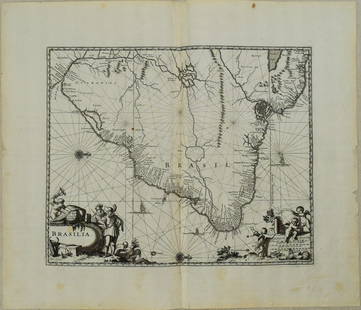
Sold20221650 Blaeu Map of Brazil -- BrasiliaTitle: 1650 Blaeu Map of Brazil -- Brasilia Cartographer: J Blaeu Year / Place: 1650, Amsterdam Map Dimension (in.): 15.2 X 19.5 in. This is a magnificent large map of most of Brazil, Guiana and UruguSee Sold Price
Sold20181650 Blaeu Map of Egypt -- Nova Aegypti TabulaTitle/Content of Map: 1650 Blaeu Map of Egypt -- Nova Aegypti Tabula Date Printed: 1650 c., Amstredam Cartographer: Blaeu [family] Size: 17.3 x 20.4 in. This is a very uncommon map of the Upper Nile pSee Sold Price
Sold2017Blaeu Map of BrazilMaritima Brasiliae Universa. Joan Blaeu (1596-1673). Engraved map with original color in part. Amsterdam: Blaeu, 1647. 21 x 24 1/2 inches sheet, 32 1/2 x 36 inches framed. This separately issued and rSee Sold Price
Sold20231671 Ogilby Map of Brazil -- BrasiliaTitle: 1671 Ogilby Map of Brazil -- Brasilia Cartographer: J Ogilby Year / Place: 1671, London Map Dimension (in.): 11.3 X 13.8 in. This is an excellent map of the eastern part of Brazil. There is anSee Sold Price
Sold2021Blaeu 1650 Map of WiltshireDESCRIPTION: Map of Wiltshire, Great Britain features a huge double column containing armorial of the Earls of Wiltshire flanked by two gentleman. Also includes royal coat of arms, small cartouche menSee Sold Price
Sold2017Blaeu: Antique Map of Brazil, 1634Map: Novus Brasiliae Typus Cartographer: Blaeu Place & Date: Amsterdam / 1634 (circa) Size: 19 1/2" x 15" Condition: b&w; cleaned; some minor spotting; centerfold reinforced Blaeu's superb, Hondius-deSee Sold Price
Sold2024Churchill & Nieuhof 1744 Folio Map. Brasilia BrazilFolio Copper Engraved Map Published 1704-47 [1744] London for "A Collection of Voyages and Travels..." By Awnsham & John Churchill. The work based mostly on the Voyages and Travels into Brasil and theSee Sold Price
Sold2024Blaeu Map of the Amazon Region, BrazilBLAEU, Willem Janszoon (1571-1638). Guiana Siue Amazonum Regio. Engraved map with original hand color. Amsterdam, c. 1640. 18 1/2" x 22 3/4" sheet.See Sold Price
Sold2020Joan Blaeu Map of Amersfoort ca. 1650Joan Blaeu (1596-1673), "Amisfurtum," Amsterdam, ca. 1650. Hand colored map of the town of Amersfoort in the Netherlands. Dimensions: Sight; height: 16 1/4 in x width: 20 1/4 in. Framed; height: 17 3/See Sold Price
Sold2018Blaeu: Antique Map of Europe, 1650Title/Content of Map: Highly decorative Map by Blaeu Date Printed: c1650 Cartographer: W. Blaeu Material/Medium: Paper Size: 19" x 24" Hand colored engraved Map. French text on Verso. Magnificent examSee Sold Price
Sold2022Blaeu Brasilia, c 1640BLAEU, Joan Blaeu (1596-1673). Brasilia... Engraved map with original hand color in part. Amsterdam, c. 1640. 19 7/8" x 23 3/8" sheet. A fine and attractive map of Brasil, first discovered by Pedro ?lSee Sold Price
Sold2019Attributed to Johannes Blaeu (1650-1712) Dutch.Attributed to Johannes Blaeu (1650-1712) Dutch. "Tvrcicvm Imperivm", Map, 16.5" x 21".See Sold Price
Sold2020Blaeu Map of Tierra del Fuego or Magellanica 1650Willem Janszoon Blaeu (1571-1638), "Tabvla Magellanica qua Tierrae del fuego, cum beleberrimis fretis a F. Magellano et I. Le Maire detectis novissima et accuratissima descriptio exhibetur," AmsterdamSee Sold Price
Sold2016Natolia, quae olim Asia minor by Joannis Blaeu 1650Map Title: Natolia, quae olim Asia minor Artist: Joannis Blaeu Publisher: Guiljelmum Blaeu, Amsterdam Date: 1650 Size: 15 x 19.5 inches Medium: Hand colored copper plate engraving A beautiful map of TSee Sold Price
Sold2017Majorca, Minorca, & Ibiza Islands Map, Jansson, 1650Insulae Balearides et Pytiusae. Jansson's edition of Blaeu's beautiful map of the islands of Majorca, Minorca, and Ibiza, including the coasts of Catalonia and Valencia. As in Blaeu's version, sea monSee Sold Price
Sold2017Jansson: Accuratissima Brasiliae Tabula Map, 1650Map: Accuratissima Brasiliae Tabula Cartographer: Jansson Place & Date: Amsterdam / 1650 (circa) Size: 19" x 14 3/4" The interior of Jansson's superb map of Brazil features scenes of native life—napSee Sold Price
Sold202417th century Brazil original map. "Prefecturae Paranburae Pars Borealis" map by Blaeu. Sheet size:17th century Brazil original map. "Prefecturae Paranburae Pars Borealis" map by Blaeu. Sheet size: 18.875 x 23.375in.See Sold Price
Sold2023Map, Joan BlaeuJoan Blaeu (Dutch, 1596-1673), "Ukrainae pars, quae Podolia Palatinatus vulgo Dicitur," circa 1650, copper engraved map with hand coloring, unsigned, overall (with frame): 27.25"h x 30.25"wSee Sold Price
Sold2023Atq JOHAN HOMANN Peru & Brazil Cartographic MapAntique circa first half of 18th century cartographic map of Peru and Brazil. Maker Homanianos Heredes (Johann Homann). Reads: Tabula America Specilialis Geographica Regni Peru, Brasilia Terra Firma.See Sold Price
Sold202017th C. Map of ItalyCapitanata, Olim Mesapiae Et Iapygiae Pars; from Blaeu's Theatrum, 1650. Hand colored with decorative cartouche. Framed, 26" x 22.5". From Godspeed's Book Shop, Boston.See Sold Price
Sold2023BLAEU C. 1650 LUXEMBOURG BELGIUMEngraved map with possibly original hand coloring. Center fold as issued. Text on back. Dimensions: (Paper) H 20" x W 23" Condition: Age toning, particularly at edges. Old water stains to top and bottSee Sold Price
Sold2015Printed Map, Willem Janszoon BlaeuWillem Janszoon Blaeu (Dutch 1571-1638), "Stiria Steymourck," circa 1650, hand-colored copper engraved map, sheet: 16"h x 21"wSee Sold Price
Sold2018Bleau Map of AsiaBLAEU, Willem Janszoon (1571-1638). Asia Noviter Delineata…Engraved map with original hand color. Amsterdam, c. 1618-1650. 20 x 24 inches sheet, 25 1/8 x 21 3/8 inches framed This is one of the mostSee Sold Price
Sold202417th Century Map of the Netherlands Area, by J. Blaeu,hand colored, circa 1650, approx. 16" X 20" plus mat and frame. Well known retailers tag, see photosSee Sold Price
BonhamsSPEED (JOHN) AND WILLEM BLAEU Pictorial title-pages to Speed's 'Theatre of the Empire of Great B...£10
Jun 12Jasper52ZEELANDIA INSULA DANICARUM MAXIMA. Seeland Sjælland Copenhagen BLAEU c1667 mapUS$260
Jun 12Jasper52Wigorniensis Comitatus et Warwicensis…Worcestershire/Warwickshire BLAEU 1645 mapUS$440
2 days LeftFreeman's | Hindman[MAP]. TODESCHI, Pietro. [Nova et Acurata Totius Americae Tabula auct. G.I. Blaeu] America quartaUS$5,000
BonhamsBLAEU (JAN) Delfi Batavorum vernacule Delft, [Amsterdam, 1649 or later]; BLAEU (WILLEM) Novus X...£10
4 days LeftWorthington GalleriesFirst Edition Hand-colored Map THE NORTH RIDING OF YORKSHIRE by Robert MordenUS$50


![1650 Blaeu Map of Egypt -- Nova Aegypti Tabula: Title/Content of Map: 1650 Blaeu Map of Egypt -- Nova Aegypti Tabula Date Printed: 1650 c., Amstredam Cartographer: Blaeu [family] Size: 17.3 x 20.4 in. This is a very uncommon map of the Upper Nile p](https://p1.liveauctioneers.com/5584/124870/63536077_1_x.jpg?height=310&quality=70&version=1531863645)


![Churchill & Nieuhof 1744 Folio Map. Brasilia Brazil: Folio Copper Engraved Map Published 1704-47 [1744] London for "A Collection of Voyages and Travels..." By Awnsham & John Churchill. The work based mostly on the Voyages and Travels into Brasil and the](https://p1.liveauctioneers.com/3952/320085/171971821_1_x.jpg?height=310&quality=70&version=1708266709)


![[MAP]. TODESCHI, Pietro. [Nova et Acurata Totius Americae Tabula auct. G.I. Blaeu] America quarta (1 of 1)](https://p1.liveauctioneers.com/197/329395/177650542_1_x.jpg?height=282&quality=70&version=1715364962)
![BLAEU (JAN) Delfi Batavorum vernacule Delft, [Amsterdam, 1649 or later]; BLAEU (WILLEM) Novus X... (1 of 9)](https://p1.liveauctioneers.com/1043/319451/178359083_1_x.jpg?height=282&quality=70&version=1717515630)


