Sold20221862 Town of Montgomery Pictorial MapDated 1862 Town of Montgomery Pictorial Farm Map in Gd. Cond. w/ Frame 38"H x 55"W -38in.H.x55in.W. w/FrameSee Sold Price
Sold20231862 Montgomery, NY Farmer's MapEarly Montgomery, NY Pictoral Farmer's Map in Gd. Cond. (Has Character)See Sold Price
Sold2022PAIGE, Paul. A Map of Cape Cod. East Brewster, MA, ca. 1940...PAIGE, Paul. A Map of Cape Cod. East Brewster, MA, ca. 1940s. Pictorial map showing towns, forests, bridges, lighthouses, and landmarks, marking vacation and tourist attractions, including a key to goSee Sold Price
Sold2022Framed Andy Dagosta Illustrated Map of California, 1969**Originally Listed At $250** Andrew "Andy" Dagosta (1923-2009). "California Lost Mines and Ghost Towns Early Spanish Missions" pictorial map, printed by Cooper Enterprises, Arizona, 1969. A vintage iSee Sold Price
Sold2023Leslie MacDonald Gill (1884-1947) 'The Wonderground Map of London Town' c. 1924England, 20th century. Printed and Published by the Westminster Press, 11 Henrietta Street, Covent Garden, [1927]. Pictorial map printed in full color, 29” x 36.5” plus margins. The map waSee Sold Price
Sold2022WINTERS, Raymond. Las Vegas / Still a Frontier Town. 1939. ...WINTERS, Raymond. Las Vegas / Still a Frontier Town. 1939. Las Vegas Chamber of Commerce. Color pictorial map of Las Vegas and the surrounding points of interest including towns, parks, canyons, lakesSee Sold Price
Sold2023ASSORTED EUROPEAN / AFRICAN PICTORIAL MAPS, LOT OF TWOASSORTED EUROPEAN / AFRICAN PICTORIAL MAPS, LOT OF TWO, engraving on paper, comprising a bird's-eye view of the siege of the town Oost Ende (Ostend), a Flemish town, during The Eighty Years' WSee Sold Price
Sold2021MORA, Jo (1876-1947). California / El Dorado of theMORA, Jo (1876-1947). California / El Dorado of the West. Monterey, 1945. Lithograph pictorial map, or “carte,” of California. Numerous cartoonish illustrations of cities and towns, nationSee Sold Price
Sold2018TOWN OF WALLKILL NEW YORK MAP, HUGHES 1862TOWN OF WALLKILL NEW YORK MAP, HUGHES 1862 41" X 53"See Sold Price
Sold2021Map of Vermont/N. Hampshire during Civil WarVery clean, sound map of these two northern states during the early time of the Civil War. From Mitchell’s 1862 New General Atlas. Shows topography, lakes, towns, rivers, etc. Full, original hanSee Sold Price
Sold20221862 RR map of Mass., Conn., Rhode Island, MitchellDetailed map of Southern New England, colored by counties and showing towns, railroads, rivers and other details. Shows the railway system in this region in the early years of the Civil War. One of thSee Sold Price
Sold2017Mitchell: Map of France Spain Portugal Helvetia 18621862 Mitchell Map of France, Spain, Portugal and Helvetia. An attractive map of Southwestern Europe. Switzerland and Corsica are shown in inserts. Lots of topographical details along with towns and ciSee Sold Price
Sold2022(PICTORIAL MAPS.) John Diakoff; G. Primakoff; and P. Sergeeff. Map of China.(PICTORIAL MAPS.) John Diakoff; G. Primakoff; and P. Sergeeff. Map of China. Enormous chromolithographed map of China with profuse pictorial illustration, inset charts, reference tables, and scenic viSee Sold Price
Sold2022(PICTORIAL MAPS.) Ignatz Sahula. Map of the 18th Annual Convention of the National Association of(PICTORIAL MAPS.) Ignatz Sahula. Map of the 18th Annual Convention of the National Association of Real Estate Boards. City of Detroit - June 23 to June 26 1925. Detroit is Yours Realtors! Large color-See Sold Price
Sold2023A Decorative Pictorial Map of The New York Worlds Fair by William L. Longyear (American, 1899-1980)A Decorative Pictorial Map of The New York Worlds Fair by William L. Longyear (American, 1899-1980). Framed. Designed and copyrighted by William Longyear. Lithographed in U.S.A by Polygraphic CompanySee Sold Price
Sold2021Pictorial Map of Nantucket by Austin StrongHand colored in original and great condition, professionally matted and framed, c. 1921, 14 H inches x 17 W inches sight, 23 H inches x 26 W inches, overall. Austin Strong (1881-1952)Austin Strong, stSee Sold Price
Sold2020Pictorial map of Dude Ranches of the WestHeading: (Sportsman's...) Author: Blakeman, T.G. Title: The Sportsman's Dude Ranch Map Place Published: Boston Publisher:The Sportsman Publishing Co. Date Published: 1934 Description: <See Sold Price
Sold2020Color pictorial map of Panama Mail Steam Ship routeHeading: (Panama Mail Steamship - color pictorial map) Author: Godwin, Harrison Title: The sea coastes of America shewing the ports of call of the Panama Mail Steamships as the country there aboutes iSee Sold Price
Sold2020Rare pictorial map of Peking 1936Heading: (China - Beijing) Author: Dorn, Frank Title: A Map and History of Peiping, formerly known as Peking... Place Published: Tienstsin-Peiping Publisher:Peiyang Press, Ltd. Date Published: </See Sold Price
Sold2022(PICTORIAL MAPS.) Charles Turzak & Henry Chapman. An Illustrated Map of Chicago • Youthful(PICTORIAL MAPS.) Charles Turzak & Henry Chapman. An Illustrated Map of Chicago • Youthful City of the Big Shoulders • Restless • Ingenious • Wilful • Violent • ProSee Sold Price
Sold2022Marvelous pictorial map of the WorldHeading: (Maps) Author: Ensign & Thayer Title: World at One View Place Published: New York Publisher: Date Published: 1847 Description: Lithographed double-hemisphere map of theSee Sold Price
Sold2023Rosalind H. Sturges, Philadelphia pictorial mapRosalind H. Sturges, Philadelphia pictorial map, Rosalind Howe Sturges (American, 1907-1999), "Philadelphia", drawing on paper, signed and dated "Rosalind H. Sturges, fecit 1966, 70" at lower left, 24See Sold Price
Sold2021[HAWAII] Dole Pictorial Map of the Hawaiian Islands.[HAWAII] Dole Pictorial Map of the Hawaiian Islands. 1937. Offset lithograph. Scarce pre-war pictorial map of the islands, filled with vignettes of the natural and man-made landmarks, modes of transpoSee Sold Price
Sold2022(PICTORIAL MAPS.) D.E. Bates. Cunard R.M.S. Caronia / Great African Cruise 1950.(PICTORIAL MAPS.) D.E. Bates. Cunard R.M.S. Caronia / Great African Cruise 1950. Color offset-printed pictorial map advertising the Caronia's route on a two-and-a-half-month's-long affair: departing NSee Sold Price
18 hrs LeftActivity AuctionsOriginal Travel Poster Vail Colorado Ski Pictorial Map Winter Sports Nature HikeUS$250
May 31Freeman's | Hindman[CIVIL WAR - ARMY OF POTOMAC]. A group of 18 CDVS of Union generals, incl. HeintzelmanUS$300
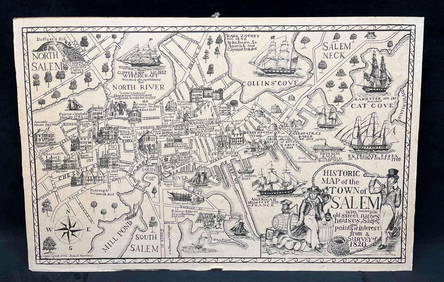
2 days LeftRapid Estate Liquidators and Auction GalleryHistoric Map Of The Town Of Salem Print Copyright John T. NortheyUS$25
Jun 07Freeman's | Hindman[MAP]. SARTINE, Antoine Plan de la Barre et du Havre de Charles-Town...1778. RARE REVOLUTIONARY WARUS$1,000(1 bid)
Jun 01Link Auction GalleriesDry, Camille, N. Pictorial St. Louis: The Great Metropolis of the Mississippi Valley. AUS$1,500
May 25Aurora Antique Auction House LtdWanli 45 April Jizao town Kubao silver ingots weigh one hundred and twoUS$500
Jun 15Hess Fine AuctionsGuillermo Gomez Gil (1862-1942) Signed Oil on Canvas Painting Flamenco Spanish Guitarist PaintingUS$10
May 31Freeman's | Hindman[CIVIL WAR]. Archive of items related to Elisha Hunt RHODES (1842-1917), 2nd Rhode Island VolunteerUS$750
Jun 06Freeman's | HindmanTHOREAU, Henry David (1817-1862). [The Season Books]. Early Spring in Massachusetts. 1881. --US$400
Jun 06Freeman's | HindmanTHOREAU, Henry David (1817-1862). Walden: or, Life in the Woods. Boston: Ticknor & Fields, 1854.US$3,000
5 days LeftForum AuctionsAfrica.- Schillings (C.G.) In Wildest Africa, first American edition, New York & London, Harper &£75
6 days LeftPotter & Potter AuctionsFOOTE, Shelby (1916-2005). The Civil War. A Narrative. New ...US$200


![Leslie MacDonald Gill (1884-1947) 'The Wonderground Map of London Town' c. 1924: England, 20th century. Printed and Published by the Westminster Press, 11 Henrietta Street, Covent Garden, [1927]. Pictorial map printed in full color, 29” x 36.5” plus margins. The map wa](https://p1.liveauctioneers.com/7899/310285/166001628_1_x.jpg?height=310&quality=70&version=1700492487)


![[HAWAII] Dole Pictorial Map of the Hawaiian Islands.: [HAWAII] Dole Pictorial Map of the Hawaiian Islands. 1937. Offset lithograph. Scarce pre-war pictorial map of the islands, filled with vignettes of the natural and man-made landmarks, modes of transpo](https://p1.liveauctioneers.com/928/200564/101543113_1_x.jpg?height=310&quality=70&version=1618323144)


![[CIVIL WAR - ARMY OF POTOMAC]. A group of 18 CDVS of Union generals, incl. Heintzelman (1 of 4)](https://p1.liveauctioneers.com/197/329785/177758291_1_x.jpg?height=282&quality=70&version=1715625218)


![[MAP]. SARTINE, Antoine Plan de la Barre et du Havre de Charles-Town...1778. RARE REVOLUTIONARY WAR (1 of 1)](https://p1.liveauctioneers.com/197/329395/177650540_1_x.jpg?height=282&quality=70&version=1715364962)


![[CIVIL WAR]. Archive of items related to Elisha Hunt RHODES (1842-1917), 2nd Rhode Island Volunteer (1 of 6)](https://p1.liveauctioneers.com/197/329785/177758366_1_x.jpg?height=282&quality=70&version=1715625218)

![THOREAU, Henry David (1817-1862). [The Season Books]. Early Spring in Massachusetts. 1881. -- (1 of 1)](https://p1.liveauctioneers.com/197/329405/177652637_1_x.jpg?height=282&quality=70&version=1715364568)

![Milne (A.A.) [The Christopher Robin books], first editions, 1924-28. (1 of 1)](https://p1.liveauctioneers.com/5458/329231/177515073_1_x.jpg?height=282&quality=70&version=1715269091)


