Sold20231877 Mitchell Map of Utah and Nevada [verso] Arizona and New Mexico -- County Map of of Utah andTitle: 1877 Mitchell Map of Utah and Nevada [verso] Arizona and New Mexico -- County Map of of Utah and Nevada [verso] County Map Arizona and New Mexico Cartographer: S Mitchell Year / Place: 1877 PhiSee Sold Price
Sold20191876 Mitchell Map of Utah and Nevada [verso] ArizonaTitle/Content of Map: 1876 Mitchell Map of Utah and Nevada [verso] Arizona and New Mexico -- County Map of of Utah and Nevada [verso] County Map Arizona and New Mexico Date: 1876 Philadelphia CartograSee Sold Price
Sold20201869 Mitchell Map of Western US [verso] Mexico andTitle: 1869 Mitchell Map of Western US [verso] Mexico and Central America -- XIX California, Oregon, Idaho, Utah, Nevada, Arizona and Washington [verso] XX Mexico and Central America Cartographer: S MSee Sold Price
Sold2020Map of California, Oregon Utah Nevada +Map of California, Oregon, Idaho, Utah, Nevada, Arizona and Washington PLUS Mexico and Central America on verso Two maps on one sheet. (back to back). Hand colored.See Sold Price
Sold2018Gray's New Map of Utah [verso] Arizona and New MexicoTitle/Content of Map: Gray's New Map of Utah [verso] Arizona and New Mexico Date: 1886, Philadelphia Cartographer: F Gray Size: 11.5 x 15 in. This is a very nice map of Utah and on the reverse New MexSee Sold Price
Sold2017VINTAGE MAPS AND MOREVINTAGE MAPS - UTAH OIL REFINING COMPANY - WESTERN STATES - SHELL - MAP OF NEVADA/UTAH AND ARIZONA/NEW MEXICO - RPM MOTOR OIL MAP - CALIFORNIA POINTS OF INTEREST AND TOURING MAP - AND MANY MORE - ALLSee Sold Price
Sold2020USA 1903 Lot of 6 State Maps. California, Utah, NevadaPlus Washington, Colorada and Arizona/New Mexico. Lithograph Maps Published 1903 by Adam & Charles Black, Edinburgh & London for "Encyclopaedia Brittannica" Tenth Edition. Centre fold as published. PaSee Sold Price
Sold2021Gray's Atlas Southwest U.S. Hand-Colored EngravingGray's Atlas, "Map of California, Nevada, Utah, Colorado, Arizona & New Mexico," hand-colored engraving on wove paper, 1873. Image: 16.5" H x 26" W; frame: 26" H x 35.5" WSee Sold Price
Sold2023Scarce Johnson map of the Great Western states, 1864Authentic vintage map of California, Utah, Nevada, Colorado, New Mexico, and Arizona. Created during a great time of expansion and change in the western United States while the Civil War was still ragSee Sold Price
Sold2019California Southwest Antique MapEarly map: California, also Utah, Nevada, Colorado, New Mexico and Arizona. Map by A.J. Johnson, New York, c. 1870. 18" x 26 1/2".See Sold Price
Sold2017Colton: Map of California Nevada Utah Colorado ArizonaColton's Map of California, Nevada, Utah, Colorado, Arizona & New Mexico, 1865/1869. Early edition of Colton's map of the Southwestern United States. Unlike in the prior edition, Nevada is no longer tSee Sold Price
Sold2022Scarce Johnson map of the Great Western states, 1864Antique map of California, Nevada, Utah, Colorado, New Mexico, and Arizona. Published during a great time of expansion and change in the U.S. West, as well as during the Civil War. Here Utah displaysSee Sold Price
Sold2017Johnson’s Map of California Territories, 18631863 Johnson’s California Territories of New Mexico, Arizona, Colorado, Nevada and Utah. Johnson and Ward, 17 x 24.5 inches. Late 1863 transitional map with New Mexico and Arizona divided verticallySee Sold Price
Sold20201839 Western States – unsettled borders, ColtonOregon, Washington, California, Colorado, Nevada, Utah, New Mexico and Arizona, J. H. Colton. 1839 copyright date found in 1864 Colton school atlas. This hand colored map was created before most westeSee Sold Price
Sold20221839 Western States – unsettled borders, ColtonOregon, Washington, California, Colorado, Nevada, Utah, New Mexico and Arizona, J. H. Colton. 1839 copyright date found in 1864 Colton school atlas. This hand colored map was created before most westeSee Sold Price
Sold2020Map of Arizona, California, Colorado, Nevada, NewTitle: Map of Arizona, California, Colorado, Nevada, New Mexico, and Utah. Publication Date: 1889 Cartographer: JOHNSON, ALVIN JEWETT Publisher: A.J. Johnson & Co. Height: 8.5 Width: 12.1 "Drawn and eSee Sold Price
Sold2018Mitchell: Antique Map of Utah and Nevada,1870Title/Content of Map: 1870 Mitchell Map of Utah and Nevada -- County Map of Utah and Nevada Date Printed: 1870 Philadelphia Cartographer: S Mitchell Size: 10.6 X 13.5 in. Handsome county map of Utah aSee Sold Price
Sold2019Mitchell: County Map of Utah & NevadaMap Title: County Map of Utah and NevadaCartographer: S. A. Mitchell Place/Date: Philadelphia / 1870 Size: 14" x 11 5/8" Condition: full color; light overall age toning The beautifully detailed and coSee Sold Price
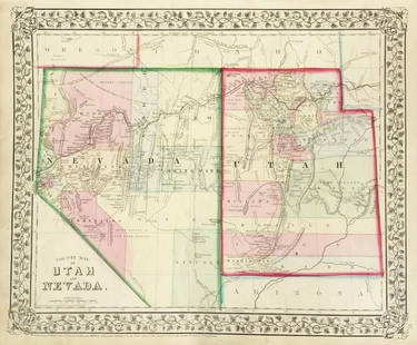
Sold2017Mitchell: Antique County Map of Utah & Nevada, 1870[Utah, Nevada]. N. p: S. Augustus Mitchell, 1870s. The map was drawn and engraved by W. H. Gamble of Philadelphia. Coloured map. Approximately 11-3/4 x 14-/4 inches image area, one sheet, matted. FineSee Sold Price
Sold2022Nevada & Utah 1880Title/Content of Map: Nevada & Utah 1880 Date Printed: 1880 Material/Medium: paper Size: folio, 23x 15 inches Additional Info: Hand colored county & township map of Utah & Nevada by Mitchell. Map measSee Sold Price
Sold2017Colton: Antique Map of New Mexico & Utah, 1859Title/Content of Map: New Mexico & Utah with today's Arizona & Nevada Date Printed: 1859 Cartographer: H. J. Colton Material/Medium: Paper Size: 17 1/2" x 15" Hand colored engraved. Published in New YSee Sold Price
Sold2020County Map of Arizona and New MexicoTitle: County Map of Arizona and New Mexico Prublication Date: 1879 Cartographer: MITCHELL, S.A. Publisher: MITCHELL, S.A. Size: 11.2Height - 14.3Width Additional Information: Colored by county (5 inSee Sold Price
Sold2022Scarce Hardesty map of Southwest US, 1875Great map of the West, noting copper, silver and gold regions throughout southern Arizona and New Mexico. “Map of Colorado, Utah, New Mexico and Arizona,” by J. David Williams. Published 1875 by HSee Sold Price
Sold2018Johnson's California, With Territories of Utah, Nevada,Title/Content of Map: Johnson's California, With Territories of Utah, Nevada, Colorado, New Mexico and Arizona Date Printed: 1864 Cartographer: JOHNSON, A.J. Material/Medium: JOHNSON AND WARD Size: 17See Sold Price
Jun 23Schilb Antiquarian Rare Books1877 Geology Geography Surveys 1ed Nevada Wyoming Utah George Wheeler US West 2vUS$1
Featured6 days LeftJasper521878 Mitchell Map of Virginia and West Virginia [verso] New Jersey, Maryland and Delaware -- CountyUS$45
2 days LeftLEAP AuctionsBoone & Crockett Pronghorn Antelope Shoulder Taxidermy Mount 84 Net All Time BookUS$20(1 bid)
421 Lots AwayKey Date Coins2008 United States Mint Set in Original Government Packaging 28 coinsUS$25
1 day LeftLEAP AuctionsNew Display Case of 21 Authentic Spear Points and Arrowheads ArtifactsUS$50(3 bids)
2 days LeftLEAP AuctionsNew Display Case of 35 Spear Points & Arrowheads Authentic Arrowheads from New Mexico.US$50(2 bids)
9 hrs LeftPotter & Potter Auctions[SANTA FE RAILWAYS]. Two ATSF railroad prints. 1955. Includ...US$50(1 bid)
Jun 30Broward Auction GalleryAFTER Leonardo Nierman (NY,Mexican,1932- 2023) acrylic paintingUS$10(1 bid)
5 days LeftKensington Estate AuctionMario Cooper (Mexican / American, 1905-1995) Published Illustration Painting, August 13, 1950US$150


![1877 Mitchell Map of Utah and Nevada [verso] Arizona and New Mexico -- County Map of of Utah and: Title: 1877 Mitchell Map of Utah and Nevada [verso] Arizona and New Mexico -- County Map of of Utah and Nevada [verso] County Map Arizona and New Mexico Cartographer: S Mitchell Year / Place: 1877 Phi](https://p1.liveauctioneers.com/5584/293457/155766077_1_x.jpg?height=310&quality=70&version=1687903812)
![1877 Mitchell Map of Utah and Nevada [verso] Arizona and New Mexico -- County Map of of Utah and First Image](https://p1.liveauctioneers.com/5584/293457/155766077_1_x.jpg?height=300&quality=1&version=1687903812&width=300)
![1877 Mitchell Map of Utah and Nevada [verso] Arizona and New Mexico -- County Map of of Utah and First Image](https://p1.liveauctioneers.com/5584/293457/155766077_1_x.jpg?height=300&quality=95&version=1687903812&width=300)
![1876 Mitchell Map of Utah and Nevada [verso] Arizona: Title/Content of Map: 1876 Mitchell Map of Utah and Nevada [verso] Arizona and New Mexico -- County Map of of Utah and Nevada [verso] County Map Arizona and New Mexico Date: 1876 Philadelphia Cartogra](https://p1.liveauctioneers.com/5584/137769/69881187_1_x.jpg?height=310&quality=70&version=1552435690)
![1869 Mitchell Map of Western US [verso] Mexico and: Title: 1869 Mitchell Map of Western US [verso] Mexico and Central America -- XIX California, Oregon, Idaho, Utah, Nevada, Arizona and Washington [verso] XX Mexico and Central America Cartographer: S M](https://p1.liveauctioneers.com/5584/188299/94765046_1_x.jpg?height=310&quality=70&version=1608072723)

![Gray's New Map of Utah [verso] Arizona and New Mexico: Title/Content of Map: Gray's New Map of Utah [verso] Arizona and New Mexico Date: 1886, Philadelphia Cartographer: F Gray Size: 11.5 x 15 in. This is a very nice map of Utah and on the reverse New Mex](https://p1.liveauctioneers.com/5584/132630/67371636_1_x.jpg?height=310&quality=70&version=1544582541)


![Mitchell: Antique County Map of Utah & Nevada, 1870: [Utah, Nevada]. N. p: S. Augustus Mitchell, 1870s. The map was drawn and engraved by W. H. Gamble of Philadelphia. Coloured map. Approximately 11-3/4 x 14-/4 inches image area, one sheet, matted. Fine](https://p1.liveauctioneers.com/5584/107399/55057774_1_x.jpg?height=310&quality=70&version=1501794677)


![1878 Mitchell Map of Virginia and West Virginia [verso] New Jersey, Maryland and Delaware -- County (1 of 2)](https://p1.liveauctioneers.com/5584/329422/177662152_1_x.jpg?height=282&quality=70&version=1715717898)


![[SANTA FE RAILWAYS]. Two ATSF railroad prints. 1955. Includ... (1 of 3)](https://p1.liveauctioneers.com/928/325952/175495377_1_x.jpg?height=282&quality=70&version=1712935174)


