Sold20191876 Mitchell Map of Utah and Nevada [verso] ArizonaTitle/Content of Map: 1876 Mitchell Map of Utah and Nevada [verso] Arizona and New Mexico -- County Map of of Utah and Nevada [verso] County Map Arizona and New Mexico Date: 1876 Philadelphia CartograSee Sold Price
Sold20231877 Mitchell Map of Utah and Nevada [verso] Arizona and New Mexico -- County Map of of Utah andTitle: 1877 Mitchell Map of Utah and Nevada [verso] Arizona and New Mexico -- County Map of of Utah and Nevada [verso] County Map Arizona and New Mexico Cartographer: S Mitchell Year / Place: 1877 PhiSee Sold Price
Sold20201869 Mitchell Map of Western US [verso] Mexico andTitle: 1869 Mitchell Map of Western US [verso] Mexico and Central America -- XIX California, Oregon, Idaho, Utah, Nevada, Arizona and Washington [verso] XX Mexico and Central America Cartographer: S MSee Sold Price
Sold2020Map of California, Oregon Utah Nevada +Map of California, Oregon, Idaho, Utah, Nevada, Arizona and Washington PLUS Mexico and Central America on verso Two maps on one sheet. (back to back). Hand colored.See Sold Price
Sold2018Gray's New Map of Utah [verso] Arizona and New MexicoTitle/Content of Map: Gray's New Map of Utah [verso] Arizona and New Mexico Date: 1886, Philadelphia Cartographer: F Gray Size: 11.5 x 15 in. This is a very nice map of Utah and on the reverse New MexSee Sold Price
Sold20201876 Mitchell map of Africa [verso] Oceania / AustraliaTitle/Content of Map: 1876 Mitchell map of Africa [verso] Oceania / Australia -- Map of Africa Showing its Most Recent Discoveries [verso] Map of Oceanica, Exhibiting it's Various Divisions Island GroSee Sold Price
Sold2019Mitchell: County Map of Utah & NevadaMap Title: County Map of Utah and NevadaCartographer: S. A. Mitchell Place/Date: Philadelphia / 1870 Size: 14" x 11 5/8" Condition: full color; light overall age toning The beautifully detailed and coSee Sold Price
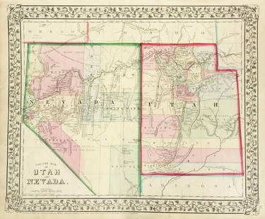
Sold2018Mitchell: Antique Map of Utah and Nevada,1870Title/Content of Map: 1870 Mitchell Map of Utah and Nevada -- County Map of Utah and Nevada Date Printed: 1870 Philadelphia Cartographer: S Mitchell Size: 10.6 X 13.5 in. Handsome county map of Utah aSee Sold Price
Sold2017Mitchell: Antique County Map of Utah & Nevada, 1870[Utah, Nevada]. N. p: S. Augustus Mitchell, 1870s. The map was drawn and engraved by W. H. Gamble of Philadelphia. Coloured map. Approximately 11-3/4 x 14-/4 inches image area, one sheet, matted. FineSee Sold Price
Sold20191876 Mitchell Map of Michigan and Wisconsin [verso]Title/Content of Map: 1876 Mitchell Map of Michigan and Wisconsin [verso] Detroit and Milwaukee -- County and Township Map of the States of Michigan and Wisconsin [verso] Plan of Milwaukee [verso] PlaSee Sold Price
Sold20191876 Mitchell Map of Virginia, West Wirginia [verso]Title/Content of Map: 1876 Mitchell Map of Virginia, West Wirginia [verso] New Jersey, Maryland, Delaware -- County Map of Virginia and West Virginia [verso] County Map of New Jersey [and] County MapSee Sold Price
Sold20191876 Mitchell Map of the Caribbean and [verso] SouthTitle/Content of Map: 1876 Mitchell Map of the Caribbean and [verso] South America -- XXI Map of the West Indies [verso] XXIV South America Date: 1876, PhiladelphiaCartographer: S Mitchell Size: 8 X 1See Sold Price
Sold2022Nevada & Utah 1880Title/Content of Map: Nevada & Utah 1880 Date Printed: 1880 Material/Medium: paper Size: folio, 23x 15 inches Additional Info: Hand colored county & township map of Utah & Nevada by Mitchell. Map measSee Sold Price
Sold20231876 Mitchell Map of France, Spain, Portugal, Switzerland [verso] Ireland and Scotland -- Map ofTitle: 1876 Mitchell Map of France, Spain, Portugal, Switzerland [verso] Ireland and Scotland -- Map of France, Spain and Portugal [verso] Ireland in Provinces and Counties [and] County Map of ScotlanSee Sold Price
Sold20191876 Mitchell Chicago [verso] St. Louis -- ChicagoTitle/Content of Map: 1876 Mitchell Chicago [verso] St. Louis -- Chicago [verso] St. Louis Date: 1876 Philadelphia Cartographer: S Mitchell Size: 13.8 X 10.8 in. Two nice Midwest City Maps of ChicagoSee Sold Price
Sold20191876 Mitchell Map of Mexico, Caribbean and HawaiiTitle/Content of Map: 1876 Mitchell Map of Mexico, Caribbean and Hawaii [verso] Cuba [verso] Alaska -- Map of Mexico, Central America and the West Indies [verso] Cuba [verso] North Western America ShoSee Sold Price
Sold2017VINTAGE MAPS AND MOREVINTAGE MAPS - UTAH OIL REFINING COMPANY - WESTERN STATES - SHELL - MAP OF NEVADA/UTAH AND ARIZONA/NEW MEXICO - RPM MOTOR OIL MAP - CALIFORNIA POINTS OF INTEREST AND TOURING MAP - AND MANY MORE - ALLSee Sold Price
Sold2017Colton: Map of California Nevada Utah Colorado ArizonaColton's Map of California, Nevada, Utah, Colorado, Arizona & New Mexico, 1865/1869. Early edition of Colton's map of the Southwestern United States. Unlike in the prior edition, Nevada is no longer tSee Sold Price
Sold20231881 Map of Utah & Nevada by Mitchell1881 Map of Utah & Nevada by Mitchell. Overall size 22 1/2"h x 29 1/2"wSee Sold Price
Sold2021Bancroft's California, Nevada, etc. 1864Heading: Author: Bancroft, Hubert Howe Title: Bancroft's Map of California, Nevada, Utah and Arizona Place Published: San Francisco Publisher:H.H. Bancroft & Company Date Published: 1864See Sold Price
Sold2021Bancroft's Map of California, Nevada, 1873Heading: Author: Bancroft, Albert Little Title: Bancroft's Map of California, Nevada, Utah and Arizona, Published by A. L. Bancroft & Compy. Booksellers & Stationers San Francisco Cal. 1873 Place PubSee Sold Price
Sold2023Scarce Johnson map of the Great Western states, 1864Authentic vintage map of California, Utah, Nevada, Colorado, New Mexico, and Arizona. Created during a great time of expansion and change in the western United States while the Civil War was still ragSee Sold Price
Sold2019California Southwest Antique MapEarly map: California, also Utah, Nevada, Colorado, New Mexico and Arizona. Map by A.J. Johnson, New York, c. 1870. 18" x 26 1/2".See Sold Price
Sold20181876 Mitchell Map of China, India and SouthEast AsiaReserve Reduced! Title/Content of Map: 1876 Mitchell Map of China, India and SouthEast Asia [verso] Palestine -- Map of Hindoostan, Farther India, China, Tibet [verso] A New Map of Palestine or the HoSee Sold Price
7 days LeftJasper521878 Mitchell Map of Virginia and West Virginia [verso] New Jersey, Maryland and Delaware -- CountyUS$45
22 hrs LeftJasper52Europe. Austria-Hungary. East Roumelia. Ticino shown as Italian. HUGHES 1876 mapUS$20
7 days LeftJasper521878 Mitchell Map of Washington, Oregon, Idaho, much of Montana [verso] Territory of IdahoUS$55
2 days LeftPotter & Potter AuctionsPictorial Map of Hollywood and Vicinity / Hollywood Film Ca...US$125(1 bid)
19 hrs LeftBonhamsJOAN MITCHELL (1925-1992) Untitled 14 1/2 x 9 1/4 in (36.8 x 23.5 cm) (Executed in 1960)US$100,000
13 hrs LeftDirty PilotCOPE2 "Latin Artist" legend Map Painting. Urban Art, Graffiti, Street ArUS$150(2 bids)


![1876 Mitchell Map of Utah and Nevada [verso] Arizona: Title/Content of Map: 1876 Mitchell Map of Utah and Nevada [verso] Arizona and New Mexico -- County Map of of Utah and Nevada [verso] County Map Arizona and New Mexico Date: 1876 Philadelphia Cartogra](https://p1.liveauctioneers.com/5584/137769/69881187_1_x.jpg?height=310&quality=70&version=1552435690)
![1876 Mitchell Map of Utah and Nevada [verso] Arizona First Image](https://p1.liveauctioneers.com/5584/137769/69881187_1_x.jpg?height=300&quality=1&version=1552435690&width=300)
![1876 Mitchell Map of Utah and Nevada [verso] Arizona First Image](https://p1.liveauctioneers.com/5584/137769/69881187_1_x.jpg?height=300&quality=95&version=1552435690&width=300)
![1877 Mitchell Map of Utah and Nevada [verso] Arizona and New Mexico -- County Map of of Utah and: Title: 1877 Mitchell Map of Utah and Nevada [verso] Arizona and New Mexico -- County Map of of Utah and Nevada [verso] County Map Arizona and New Mexico Cartographer: S Mitchell Year / Place: 1877 Phi](https://p1.liveauctioneers.com/5584/293457/155766077_1_x.jpg?height=310&quality=70&version=1687903812)
![1869 Mitchell Map of Western US [verso] Mexico and: Title: 1869 Mitchell Map of Western US [verso] Mexico and Central America -- XIX California, Oregon, Idaho, Utah, Nevada, Arizona and Washington [verso] XX Mexico and Central America Cartographer: S M](https://p1.liveauctioneers.com/5584/188299/94765046_1_x.jpg?height=310&quality=70&version=1608072723)

![Gray's New Map of Utah [verso] Arizona and New Mexico: Title/Content of Map: Gray's New Map of Utah [verso] Arizona and New Mexico Date: 1886, Philadelphia Cartographer: F Gray Size: 11.5 x 15 in. This is a very nice map of Utah and on the reverse New Mex](https://p1.liveauctioneers.com/5584/132630/67371636_1_x.jpg?height=310&quality=70&version=1544582541)
![1876 Mitchell map of Africa [verso] Oceania / Australia: Title/Content of Map: 1876 Mitchell map of Africa [verso] Oceania / Australia -- Map of Africa Showing its Most Recent Discoveries [verso] Map of Oceanica, Exhibiting it's Various Divisions Island Gro](https://p1.liveauctioneers.com/5584/167106/84290444_1_x.jpg?height=310&quality=70&version=1588107786)

![Mitchell: Antique County Map of Utah & Nevada, 1870: [Utah, Nevada]. N. p: S. Augustus Mitchell, 1870s. The map was drawn and engraved by W. H. Gamble of Philadelphia. Coloured map. Approximately 11-3/4 x 14-/4 inches image area, one sheet, matted. Fine](https://p1.liveauctioneers.com/5584/107399/55057774_1_x.jpg?height=310&quality=70&version=1501794677)
![1876 Mitchell Map of Michigan and Wisconsin [verso]: Title/Content of Map: 1876 Mitchell Map of Michigan and Wisconsin [verso] Detroit and Milwaukee -- County and Township Map of the States of Michigan and Wisconsin [verso] Plan of Milwaukee [verso] Pla](https://p1.liveauctioneers.com/5584/137769/69881333_1_x.jpg?height=310&quality=70&version=1552435690)
![1876 Mitchell Map of Virginia, West Wirginia [verso]: Title/Content of Map: 1876 Mitchell Map of Virginia, West Wirginia [verso] New Jersey, Maryland, Delaware -- County Map of Virginia and West Virginia [verso] County Map of New Jersey [and] County Map](https://p1.liveauctioneers.com/5584/138985/70465971_1_x.jpg?height=310&quality=70&version=1554250661)
![1876 Mitchell Map of the Caribbean and [verso] South: Title/Content of Map: 1876 Mitchell Map of the Caribbean and [verso] South America -- XXI Map of the West Indies [verso] XXIV South America Date: 1876, PhiladelphiaCartographer: S Mitchell Size: 8 X 1](https://p1.liveauctioneers.com/5584/153142/77325878_1_x.jpg?height=310&quality=70&version=1572400045)

![1876 Mitchell Map of France, Spain, Portugal, Switzerland [verso] Ireland and Scotland -- Map of: Title: 1876 Mitchell Map of France, Spain, Portugal, Switzerland [verso] Ireland and Scotland -- Map of France, Spain and Portugal [verso] Ireland in Provinces and Counties [and] County Map of Scotlan](https://p1.liveauctioneers.com/5584/283091/149355449_1_x.jpg?height=310&quality=70&version=1680038985)
![1876 Mitchell Chicago [verso] St. Louis -- Chicago: Title/Content of Map: 1876 Mitchell Chicago [verso] St. Louis -- Chicago [verso] St. Louis Date: 1876 Philadelphia Cartographer: S Mitchell Size: 13.8 X 10.8 in. Two nice Midwest City Maps of Chicago](https://p1.liveauctioneers.com/5584/138633/70306036_1_x.jpg?height=310&quality=70&version=1553637454)
![1876 Mitchell Map of Mexico, Caribbean and Hawaii: Title/Content of Map: 1876 Mitchell Map of Mexico, Caribbean and Hawaii [verso] Cuba [verso] Alaska -- Map of Mexico, Central America and the West Indies [verso] Cuba [verso] North Western America Sho](https://p1.liveauctioneers.com/5584/155577/78518607_1_x.jpg?height=310&quality=70&version=1574821323)


![1876 Mitchell Map of China, India and SouthEast Asia: Reserve Reduced! Title/Content of Map: 1876 Mitchell Map of China, India and SouthEast Asia [verso] Palestine -- Map of Hindoostan, Farther India, China, Tibet [verso] A New Map of Palestine or the Ho](https://p1.liveauctioneers.com/5584/131384/66769315_1_x.jpg?height=310&quality=70&version=1542734392)

![1878 Mitchell Map of Virginia and West Virginia [verso] New Jersey, Maryland and Delaware -- County (1 of 2)](https://p1.liveauctioneers.com/5584/329422/177662152_1_x.jpg?height=282&quality=70&version=1715717898)

![1878 Mitchell Map of Washington, Oregon, Idaho, much of Montana [verso] Territory of Idaho (1 of 2)](https://p1.liveauctioneers.com/5584/329422/177662232_1_x.jpg?height=282&quality=70&version=1715717898)


