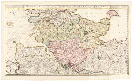
Sold2016Large map of Holstein, Germany 1720Heading: Author: Visscher, Nicolas Title: Holsatiae Ducatus Vernadule das Hertzogtum Holetein... Place Published: Amsterdam Publisher:Pieter Schenk, Jr. Date Published: c.1720 DescriptSee Sold Price
Sold202417TH C. ANTIQUE MAP SIEGE OF LA ROCHELLE, FRANCE, FRAMED"Seige et Reddition de La Rochelle, Octobre 1628", handcolored engraving on wove paper, Claes Jansz. Visscher (II), (workshop of), Germany, 1627 - 1629. In gilt molded frame, matted under UV non-glareSee Sold Price
Sold2023Visscher Map of South East AsiaVISSCHER, Nicolas (1618-1679). Indiae Orientalis, nec non Insularum Adiacentium Nova Descriptio. Engraved map with great original hand color in full. Amsterdam, c. 1698. 20 1/2" x 24 1/8" sheet. ThisSee Sold Price
Sold20211685 Visscher Map of Burgondy Area -- ComitatusTitle: 1685 Visscher Map of Burgondy Area -- Comitatus Burgundiae tam in Praecipuas ejus Praefecturas quam in minores earundem Balliviatus aliasq. Ditiones subjacentes et insertas… Cartographer: N VSee Sold Price
Sold20221670 Visscher Map of Holland -- Rhenolandia, Amstelandia et Circumjacentia aliquot Territoria ..Title: 1670 Visscher Map of Holland -- Rhenolandia, Amstelandia et Circumjacentia aliquot Territoria .. Cartographer: N Visscher Year/Place: 1670 c., Amsterdam Dimensions: 18.1 X 22.2 in. Description:See Sold Price
Sold2023After Claes Jansz Visscher, Map of ParisAfter Claes Jansz Visscher (Dutch, 1586-1652), engraving on paper depicting a 1618 map of Paris, flanked on either side by illustrations of Parisian citizens from the King and Queen, to the common vilSee Sold Price
Sold2023MAP, Germany, Braun & HogenbergMainz & Wurzburg, Germany & Sion, Switzerland. Braun & Hogenberg, Moguntia, Germaniae Metropolis, ad Rheni... [on sheet with] Herbipolis, Comuniter Wirtzburg... [and] Sedunum, Primaria & MetropoliticaSee Sold Price
Sold20211680 Visscher Map of French and Italian Alpine RegionTitle: 1680 Visscher Map of French and Italian Alpine Region -- Regiae Celsitudinis Sabaudicae Status Cartographer: N Visscher Year / Place: 1680 c. Amsterdam Map Dimension (in.): 22.8 X 19.8 in. ThisSee Sold Price
Sold2023Visscher Map of Middleburgh, HollandVISSCHER, Nicolas II (1649-1702). Untitled [Middelburgh] Engraved map with original hand color. Amsterdam, c.1690 21 1/2" x 24 3/8" sheet. Antique Map showing the then Island of Middleburgh in HollandSee Sold Price
Sold2023MAP, Germany, MunsterSouthern Germany. Sebastian Munster, Das Algow, from Cosmographey oder Beschreibung Aller Laender, 1578 (published). Hand Color. This charming woodblock map of southwestern Bavaria oriented with northSee Sold Price
Sold2024MAP, Germany, Braun & HogenbergFlensburg & Itzehoe, Germany. Braun & Hogenberg, Flensburgum [on sheet with] Itzohoa, from Civitates Orbis Terrarum, Vol. IV, 1612 (published). Hand Color. This sheet includes bird's-eye views of theSee Sold Price
Sold2022MAP, Germany, JanssonSoutheastern Germany. Jan Jansson, Franconiae Nova Descriptio, from Atlas Novus..., 1646 (circa). Hand Color. This elegantly engraved map focuses on the Franconia region of Germany, located in BavariaSee Sold Price
Sold2018FRAMED MAP, GERMANY NORTH OF THE MAYNEFramed map, "Germany, North of the Mayne", drawn and engraved for Thomson's New General Atlas, 1816, London engraved, hand colored highlights, sight approx: 20"h, 24.5"w, overall: 30"h, 34.5"w, 10.5lbSee Sold Price
Sold202118th C Large Handcolored Mercator Map GermanyLarge beautifully handcolored map of Braunswyck and Meydburg after Gerard Mercator circa 1640, this being an 18th century restike.. Printed at Amsterdam. Measures 23 x 19". Fine, reinforced central veSee Sold Price
Sold2024MAP, Germany, MunsterCentral Germany. Sebastian Munster, Francken Land in Germania..., from Cosmographei oder Beschreibung aller L?nder, 1556 (published). Hand Color. This woodblock map is oriented with north to the bottoSee Sold Price
Sold2022Barclay, James C1800 Hand Col Map. GermanyHand Colored Copper Engraved Map Published C1800 Halifax & Newcastle, England for "Barclay's Universal English Dictionary…" by James Barclay. Maps Engraved by Clerk, Milton and others. Paper Size: 1See Sold Price
Sold2019Barclay, James 1809 Hand Col Map. Germany & BohemiaHand Coloured Copper Engraved Map Published 1809, Leeds for "Barclay's Complete and Universal Dictionary of the English Language..." by the Rev. James Barclay. Folds as issued. Paper Size: 11 x 10 incSee Sold Price
Sold2021Wilkes, John 1805 Hand Col Map. GermanyFinely Hand Colored Copper Engraved Map Published 1796-1828 London for "Encyclopaedia Londinensis, or universal dictionary of arts, sciences and literature" by John Wilkes et al. Paper Size: 10.5 x 8.See Sold Price
Sold2022Barclay, James 1812 Hand Col Map. GermanyHand Colored Copper Engraved Map Published 1812-13 by Brightly & Childs, Bungay for "A Complete and Universal Dictionary of the English Language..." by the Rev. James Barclay. Paper Size: 10.5 x 8 incSee Sold Price
Sold2022Times Atlas 1895 Lot of 7 Maps. GermanyLithograph Map Published 1895, London for "The Times Atlas" Two with Centre fold as published. Paper Size: Up to 21 x 16 inch (53 x 41cm) A couple with centre fold splits. A few other minor faults inSee Sold Price
Sold2021Tallis, John (Pub) 1852 Map. GermanySteel Engraved Map with Original Outline Hand Color Published 1852-56 by John Tallis, London for "The Universal Pronouncing Dictionary" by Thomas Wright. Drawn & Engraved by John Rapkin. Centre fold aSee Sold Price
Sold2021Tallis, John (Pub) 1852 Map. GermanySteel Engraved Map with Original Outline Hand Color Published 1852-56 by John Tallis, London for "The Universal Pronouncing Dictionary" by Thomas Wright. Drawn & Engraved by John Rapkin. Centre fold aSee Sold Price
Sold2021Thomson, John (Pub) 1825 Map. GermanyCopper Engraved Map Published 1825 by John Thomson, Edinburgh for "The Edinburgh School Atlas" by N. R. Hewitt. Maps Engraved by Hewitt. Engraved Vignette in corner. Original Outline Hand Colour. RareSee Sold Price
Sold2023Thomson, John (Pub) 1825 Map. GermanyCopper Engraved Map Published 1825 by John Thomson, Edinburgh for "The Edinburgh School Atlas" by N. R. Hewitt. Maps Engraved by Hewitt. Original Outline Hand Colour. Rare. Paper Size: 10.5 x 8 inch (See Sold Price
3 days LeftTrillium Antique Prints & Rare BooksDe Wit - 6 Maps of Austria, Germany, Rhein RegionUS$75
5 hrs LeftJasper52Large Antique French map GERMAN EMPIRE 1792 colored by POIRSON engraver BassetUS$170
14 hrs LeftJasper52Le Comté d'Artois et des environs'. N France & W Belgium. VISSCHER c1680 mapUS$320
14 hrs LeftJasper52Atlanta Karte der Besatzungs-Zonen. Map of the Occupation Areas of Germany 1946US$440
24 mins LeftC & T Auctioneers and Valuers LtdTwo Vintage Action Force Red Shadows Black Major Variant Action Figures Series 2 carded moc 1983£80
3 days LeftTrillium Antique Prints & Rare BooksHomann - 6 Maps of European Countries: France, Belgium, Denmark, Spain, PortugalUS$100
Featured7 days LeftJasper521593 de Jode Maps of Eastern Germany (Saxony Area) and Western Germany -- Mansfeldiae Comitatus ...US$550
Oct 05Ripley Auctions“Visscher’s American Islands” Map (Insulae Americanae) by Nicolaes Visscher I (1619-1709)US$800
14 hrs LeftJasper52German Parish & Peel, Glenfaba Sheading, Isle of Man by James Woods 1829 mapUS$480
7 days LeftJasper521552 Munster Map of Netherlands and Western Germany -- Brabantia III Rheniet X Nova TabulaUS$240
14 hrs LeftJasper52King of Great Britain's dominions in Germany. Brunswick. JEFFERYS/FADEN 1789 mapUS$260
7 days LeftJasper521705 de Fer Map of Basel -- Basle Ville Capitale du Canton du meme nom Situee sur le Rhein…US$170
14 hrs LeftJasper52Central Africa. Congo Free State Rhodesia German East Africa. STANFORD 1894 mapUS$300
14 hrs LeftJasper52Central Africa. Congo Free State Rhodesia German East Africa. STANFORD 1896 mapUS$300


![MAP, Germany, Braun & Hogenberg: Mainz & Wurzburg, Germany & Sion, Switzerland. Braun & Hogenberg, Moguntia, Germaniae Metropolis, ad Rheni... [on sheet with] Herbipolis, Comuniter Wirtzburg... [and] Sedunum, Primaria & Metropolitica](https://p1.liveauctioneers.com/6576/279721/147265449_1_x.jpg?height=310&quality=70&version=1677104593)

![Visscher Map of Middleburgh, Holland: VISSCHER, Nicolas II (1649-1702). Untitled [Middelburgh] Engraved map with original hand color. Amsterdam, c.1690 21 1/2" x 24 3/8" sheet. Antique Map showing the then Island of Middleburgh in Holland](https://p1.liveauctioneers.com/1968/297676/158406682_1_x.jpg?height=310&quality=70&version=1690906360)

![MAP, Germany, Braun & Hogenberg: Flensburg & Itzehoe, Germany. Braun & Hogenberg, Flensburgum [on sheet with] Itzohoa, from Civitates Orbis Terrarum, Vol. IV, 1612 (published). Hand Color. This sheet includes bird's-eye views of the](https://p1.liveauctioneers.com/6576/338349/183246857_1_x.jpg?height=310&quality=70&version=1722455697)


