Sold2023After Claes Jansz Visscher, Map of ParisAfter Claes Jansz Visscher (Dutch, 1586-1652), engraving on paper depicting a 1618 map of Paris, flanked on either side by illustrations of Parisian citizens from the King and Queen, to the common vilSee Sold Price
Sold2024Claes Visscher Reproduction 1618 Map of ParisClaes Janszoon Visscher II reproduction map of the city of Paris, Lutetia Parisorum urbs, toto orbe celeberrima notissimaque, caput regni Franciae, 1618. 24 1/4" x 35 1/4" (with frame 27 1/4" x 38 3/8See Sold Price
Sold202417TH C. ANTIQUE MAP SIEGE OF LA ROCHELLE, FRANCE, FRAMED"Seige et Reddition de La Rochelle, Octobre 1628", handcolored engraving on wove paper, Claes Jansz. Visscher (II), (workshop of), Germany, 1627 - 1629. In gilt molded frame, matted under UV non-glareSee Sold Price
Sold2024Framed Vintage Style Visscher Commander Repro Map"Among the many great Dutch map publishers active in the seventeenth century were the Visscher family, begun by Claes Jansz Visscher (1587-1652) and continued by his son Nicolaas (Piscator jun. 16See Sold Price
Sold2016Schencken Schans. Claes Jansz VisscherDe Gelegentheyt ende Belegeringhe van Schencken Schans Maker: Visscher, Claes Jansz Origin: Amsterdam, circa 1650 Medium: Original copper plate engraving with later hand-coloring Sheet size: 12 1/2 xSee Sold Price
Sold2020The Four Seasons. VAN DE VELDE. Le quattro stagioni.VAN DE VELDE IL GIOVANE, Jan. Le quattro stagioni.Claes Jansz Visscher, 1617 4 Tavole inc. all’acquaforte di mm. 288x426, 292x427, 290x423, 299x434; II stato di IV con il monogramma I.V. dellSee Sold Price
Sold2022UNFRAMED OLD MASTER RELIGIOUS ENGRAVINGS, 6PCVarious artists, selection of six 17th century Old Master unframed religious New Testament engravings on laid paper published by Claes Jansz Visscher (Netherlandish, 1587-1652) including the parable oSee Sold Price
Sold202017th C Engraving Moses Burning Bush VisscherEarly 17th century engraving by Claes Jansz Visscher showing scenes from Exodus as Shepard to seeing the burning busg. Fine, measures 11.5 x 9". Reserve: $50.00 Shipping: Domestic: Flat-rate of $5.00See Sold Price
Sold202017th C Engraving Visscher Achab and NabothEngraving of Achab and Naboth from Kings 21 with beautiful detail, by Claes Jansz Visscher (1587-1652) after Maarten Heemskerch. Circa 1620. Short tear at top margin else Fine. Measures 11 x 9" ReservSee Sold Price
Sold2020Visscher, Claes .Germaniæ Inferioris XVIIVisscher, Claes .Germanie Inferioris XVII Provinciarum. Fine hand colored engraved double-page map. 18-1/2 x 22-1/2 inches plus margins, blank on verso, neatly matted; some browning, generally sound.See Sold Price
Sold2023Visscher Map of South East AsiaVISSCHER, Nicolas (1618-1679). Indiae Orientalis, nec non Insularum Adiacentium Nova Descriptio. Engraved map with great original hand color in full. Amsterdam, c. 1698. 20 1/2" x 24 1/8" sheet. ThisSee Sold Price
Sold20211685 Visscher Map of Burgondy Area -- ComitatusTitle: 1685 Visscher Map of Burgondy Area -- Comitatus Burgundiae tam in Praecipuas ejus Praefecturas quam in minores earundem Balliviatus aliasq. Ditiones subjacentes et insertas… Cartographer: N VSee Sold Price
Sold20221670 Visscher Map of Holland -- Rhenolandia, Amstelandia et Circumjacentia aliquot Territoria ..Title: 1670 Visscher Map of Holland -- Rhenolandia, Amstelandia et Circumjacentia aliquot Territoria .. Cartographer: N Visscher Year/Place: 1670 c., Amsterdam Dimensions: 18.1 X 22.2 in. Description:See Sold Price
Sold2020Sanson Orbis Vetus World Map Paris 1657Nicolas Sanson (1600-1677), "Orbis Vetus, et Orbis Veteris Utraque Continens, Terrarumque Tractus Arcticus, et Antarcticus ex Platone, Thopompo, sive Aeliano, Manilio & c." Paris: P. Mariette, 1657. HSee Sold Price
Sold20211680 Visscher Map of French and Italian Alpine RegionTitle: 1680 Visscher Map of French and Italian Alpine Region -- Regiae Celsitudinis Sabaudicae Status Cartographer: N Visscher Year / Place: 1680 c. Amsterdam Map Dimension (in.): 22.8 X 19.8 in. ThisSee Sold Price
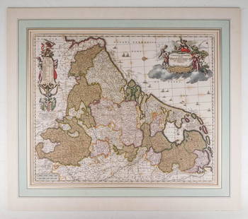
Sold2023Visscher Map of Middleburgh, HollandVISSCHER, Nicolas II (1649-1702). Untitled [Middelburgh] Engraved map with original hand color. Amsterdam, c.1690 21 1/2" x 24 3/8" sheet. Antique Map showing the then Island of Middleburgh in HollandSee Sold Price
Sold2020Large map Paris, "R.A.T.P." metropolitanLarge map Paris, "R.A.T.P." metropolitan transportation, laid down on plywood, 52.75" by 68.25"See Sold Price
Sold2023French map Paris 1900 World fair first subway line (exposition universelle)Paris map edited for the " exposition internationale de 1900 " by Garniers Freres 6 rue des Saint Peres a Paris . The first subway line opened , during the World's Fair (Exposition Universelle) ,thisSee Sold Price
Sold2019Two Framed Maps: Paris by J. Shury & HavanaA framed reproduction of an 1853 map of Havana [Framed dimensions: 17 1/4 x 21 3/4 inches], and a framed antique map of Paris, engraved by J. Shury. [Framed dimensions: 16 3/8 x 22 1/8 inches]. In gooSee Sold Price
Sold2017Antique Map, Paris View from 1815Title/Content of Map: Paris view from 1815 Date Printed: 1815 Cartographer: Unknown Material/Medium: Paper Size: 10 1/2" x 8 1/3" Published in London Please note that this lot has a confidential reserSee Sold Price
Sold2019Desnos 1765 Map. Paris to Basle. France Switzerland"Feuille Qui donne les Routes de Champagne, Lorraine, Franche Comte: Partie de la Bourgogne et de l'Alsace" Copper Engraved Map Published 1765, Paris for "Coup d'oeil general sur la France" by Louis CSee Sold Price
Sold2019Desnos 1765 Map. Paris to Frankfurt. France Germany"Fle L'Indicateur Fidele, Donne la Troisieme Route de Paris a Strasbourg..." Copper Engraved Map Published 1765, Paris for "Coup d'oeil general sur la France" by Louis Charles Desnos & Louis Brion deSee Sold Price
Sold2019Desnos 1765 Map. Paris to Bordeaux. France"Ille Feuille Qui donne les Routes de Paris a Bordeaux et Toulouse &Ca" Copper Engraved Map Published 1765, Paris for "Coup d'oeil general sur la France" by Louis Charles Desnos & Louis Brion de la ToSee Sold Price
Sold2019Desnos 1765 Map. Paris to Strasbourg, France"L'Indicateur Fidele du Voyageur Francois qui donne la 3me Route de Paris a Strasbourg" Copper Engraved Map Published 1765, Paris for "Coup d'oeil general sur la France" by Louis Charles Desnos & LouiSee Sold Price
2 days LeftAlbion AuctionsDe La Force, Jean 1730 Road Map. Paris a Rouen, Dieppe, Le Havre?US$5(1 bid)
17 hrs LeftJasper52EUROPEAN CITIES. Environs of Paris Brussels Amsterdam Geneva.JOHNSTON 1899 mapUS$20
17 hrs LeftJasper52EUROPEAN CITIES. Environs of Paris Brussels Amsterdam Geneva. JOHNSTON 1910 mapUS$20
17 hrs LeftJasper52EUROPEAN CITIES. Environs of Paris Brussels Amsterdam Geneva. JOHNSTON 1906 mapUS$20
Jun 07Freeman's | HindmanBELLIN, Jacques-Nicolas. Carte Reduite de L'Ocean Oriental ou Mer Des Indies. Paris, 1757. SecondUS$150
17 hrs LeftJasper52EUROPEAN CITIES. Environs of Paris Brussels Amsterdam Geneva.JOHNSTON 1903 mapUS$20
17 hrs LeftJasper52EUROPEAN CITIES. Environs of Paris Brussels Amsterdam Geneva.JOHNSTON 1900 mapUS$20
7 days LeftJasper521749 MAP CARTE DE LA TARTARIE ORIENTALE RUSSIA & CHINA antique EASTERN TARTARYUS$35
17 hrs LeftJasper52South-west Europe. Swiss Savoy. British Hanover. THOMSON 1817 old antique mapUS$100
7 days LeftJasper521758 MAP PARTIE DE LA MER GLACIALE contenants La Nouvelle Zemble RUSSIA antiqueUS$55
Featured17 hrs LeftJasper52Europe after the Congress of Vienna. 4 sheets. 128x106cm. THOMSON 1817 old mapUS$550
10 hrs LeftLos Angeles Modern AuctionsChristo, Wrapped Trees (Project for Avenue des Champs-Elysees, Paris)US$5,000
1 day LeftPotter & Potter AuctionsAUDIBERTI, J. Choain. Afrique Equatoriale Francaise. Paris:...US$100(1 bid)
1 day LeftPotter & Potter Auctions[CAPPIELLO]. Reglisse “Car.” Demandez Le Baton Car. Paris: ...US$100


![Visscher Map of Middleburgh, Holland: VISSCHER, Nicolas II (1649-1702). Untitled [Middelburgh] Engraved map with original hand color. Amsterdam, c.1690 21 1/2" x 24 3/8" sheet. Antique Map showing the then Island of Middleburgh in Holland](https://p1.liveauctioneers.com/1968/297676/158406682_1_x.jpg?height=310&quality=70&version=1690906360)


![Two Framed Maps: Paris by J. Shury & Havana: A framed reproduction of an 1853 map of Havana [Framed dimensions: 17 1/4 x 21 3/4 inches], and a framed antique map of Paris, engraved by J. Shury. [Framed dimensions: 16 3/8 x 22 1/8 inches]. In goo](https://p1.liveauctioneers.com/1221/144060/73206131_1_x.jpg?height=310&quality=70&version=1562178741)


![[CAPPIELLO]. Reglisse “Car.” Demandez Le Baton Car. Paris: ... (1 of 1)](https://p1.liveauctioneers.com/928/325952/175495191_1_x.jpg?height=282&quality=70&version=1712935174)