Sold2018U.S. Coast Survey 1853 Map of Aransas Pass, Texas"Reconnoissance of Aransas Pass Texas" Electrotype Map Published 1843-65, Washington for "Report of the Superintendent of the U.S. Coast Survey..." Published under the supervision and direction of AleSee Sold Price
Sold20211853 Geological Map of Passes by St. Gabriel Mountains,Title: 1853 Geological Map of Passes by St. Gabriel Mountains, CA -- Geological Map of the Tejon Pass & Canada de las Unas Including the Pass of San Franciscoquito & Williamson's Pass Cartographer: WSee Sold Price
Sold20211853 Williamson Map of California's Tejon Pass Area --Title: 1853 Williamson Map of California's Tejon Pass Area -- Map of the Passes in the Sierra Nevada from Walker's Pass to the Coast Range under the direction of the Hon. Jefferson Davis, Secretary ofSee Sold Price
Sold2023Williamson, Lieut. R. S. 1856 Map. California - Tejon Pass & Canada de las Uvas"Geological Map of the Tejon Pass & Canada de las Uvas and the Vicinity. Including the Pass of San Francisco & Williamsons Pass"Lithograph Map Published 1853-61, Washington for "Reports of explorationSee Sold Price
Sold2023Williamson, Lieut. R. S. 1856 LG Chart. California - Bernadino Pass, San Bernardino, Colorado Desert"Geological Sections of the Bernadino Pass" Lithograph Map Published 1853-61, Washington for "Reports of explorations and surveys, to ascertain the most practicable and economical route for a railroadSee Sold Price
Sold2018U.S Coast Survey 1853 Map. Timballier Bay, Louisiana"Preliminary Reconnaissance of Grand Pass Entrance to Timballier Bay Louisiana" Electrotype Map Published 1843-65, Washington for "Report of the Superintendent of the U.S. Coast Survey..." Published uSee Sold Price
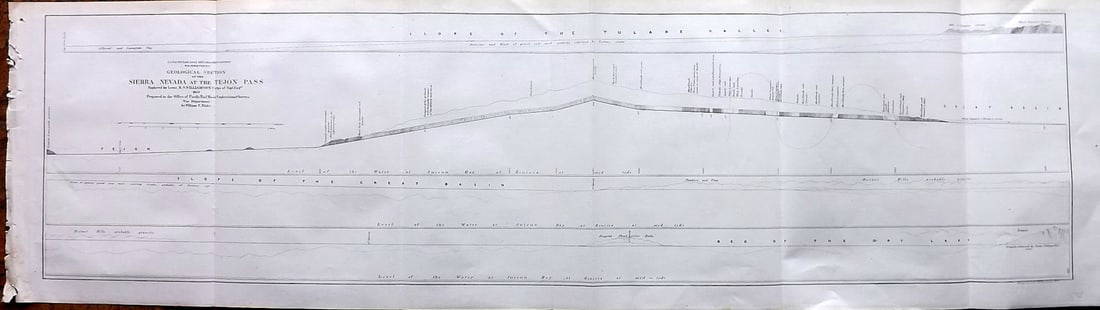
Sold2023Williamson, Lieut. R. S. 1856 LG Chart. California - Sierra Nevada & Tejon Pass"Goelogical Section of the Sierra Nevada at the Tejon Pass" by R. S. Williamson. Lithograph Map Published 1853-61, Washington for "Reports of explorations and surveys, to ascertain the most practicablSee Sold Price
Sold2023Ruth Duncan, "Shrimp Boats, Aransas Pass"Ruth Duncan (Texas, 1908-2002), "Shrimp Boats, Aransas Pass", oil on masonite sight: 24 x 30 in., frame: 31 x 37 in. €â€¹€â€¹€â€¹€â€¹€â€¹€âSee Sold Price
Sold2015Thayer's 1853 Map of The United StatesHand colored lithograph laid on canvas by Horace Thayer & Co., NY, showing map surrounded by vignete scenes from American history. 43 1/4" x 30 1/2" with original ebonized wood hangers.See Sold Price
Sold20201853 Map of Nantucket Harbor Survey of the Coast of the1853 Map of Nantucket Harbor Survey of the Coast of the United States, "From a Trigonometrical Survey under the direction of A.D. Bache Superintedent of the Survey of the Coast of the United states. TSee Sold Price
Sold2023James Wyld, 1853 Map of ChinaTitle/Content of Map: James Wyld, 1853 Map of ChinaDate Printed: 1853Cartographer: James WyldMaterial/Medium: paper. Steel engravedSize: 82cm x 63.7cmProvenance: Bought from long time Asian map collecSee Sold Price
Sold2017Fascinating 1853 Map of Western StatesFascinating 1853 map of Western States. Daniel Burgess. Early, interesting configuration of the West prior to the inclusion of Colorado, Idaho, Wyoming, Montana, Nevada and Arizona. New Mexico TerritoSee Sold Price
Sold2021H.F. Bridgens 1853 Map of Manheim, PA.H.F. Bridgens 1853 Map of Manheim, PA. 40" x 55" overall. Condition: Fair with toning, tears and loss.See Sold Price
Sold20221853 map of North America, Roswell C. SmithSchool map of the North American continent when Canada was still known as British America and Alaska was Russian America. Full, original hand coloring. “Map of North America” by Roswell C.See Sold Price
Sold2018Scarce 1853 map from Colton’s 1856 Atlas of the WorldReserve Reduced! An attractive and scarce 1853 Colton map of Washington and Oregon, inclusive of the modern-day states of Idaho, Montana & Wyoming. This map appeared in the 1856 Colton 2-volume AtlasSee Sold Price
Sold2022Plan of Improvement of Aransas Pass Texas As Proposed by Board Of Engineers, U.S.A. ... Nov. 22,Publication Date: 1899-01-01 Title: Plan of Improvement of Aransas Pass Texas As Proposed by Board Of Engineers, U.S.A. ... Nov. 22, 1897 Cartographer: ROBERT, HENRY MARTYN (1837-1923) Publisher: GPOSee Sold Price
Sold20221853 map of the South, Burgess/SmithInteresting map of four southern states. Includes population and other details. Shows towns, counties, roads, railroads, mountains, rivers, islands, bays. Early primitive Florida treatment, prior to tSee Sold Price
Sold2018Eastman 1853 Map of New MexicoThe South Western Part of New Mexico . Compiled from the latest explorations and drawn by Capt. S. Eastman. 9 1/2"h. x 12 1/2"W.See Sold Price
Sold2024... (Sketch I No. 3) Aransas Pass Coast of Texas.Publication Date: 1851 Title: ... (Sketch I No. 3) Aransas Pass Coast of Texas. Cartographer: CRAVEN, T. A. Publisher: U.S.C.S. Height: 7.3 Width: 8 "Reconnaissance made in pursuance of Act of CongresSee Sold Price
Sold2024Burgess & Cain 1853 Map #9 Wisc and MichTitle: Burgess & Cain 1853 Map #9 Wisc and Mich Dimension: 11 ½” x 9 ½” Provenance:A beautiful colored map of what were the middle states in 1853. It shows all the major cities,See Sold Price
Sold2023Burgess & Cain 1853 Map #7 OH, IN, KY, TNTitle: Burgess & Cain 1853 Map #7 OH, IN, KY, TN Dimension: 11 ½” x 9 ½” Provenance:A beautiful colored map of what were the northern middle states in 1853. It shows all the majoSee Sold Price
Sold2021Tallis (Pub) 1853 Map of Prussia, GermanySteel Engraved Map Published 1853-4 by John Tallis, London for "The Life and Times of the Late Duke of Wellington" by Thomas Gaspey. Drawn and Engraved by John Rapkin. Centre fold as published. PaperSee Sold Price
Sold2021Tallis (Pub) 1853 Map of GermanySteel Engraved Map Published 1853-4 by John Tallis, London for "The Life and Times of the Late Duke of Wellington" by Thomas Gaspey. Drawn and Engraved by John Rapkin. Centre fold as published. PaperSee Sold Price
Sold2022Buffon & Tardieu 1853 Map. Ancient World"Carte de l'Ancien Continent" Steel Engraved Map with outline hand color Published 1853-55, Paris for "Oeuvres Completes de Buffon" by the Comte de Buffon. Engraved by Ambroise Tardieu. Paper Size: 10See Sold Price
7 days LeftJasper521853 Williamson Map of Tejon Pass, California -- Map and Profile of the Tejon Pass from explorationsUS$55
7 days LeftJasper521853 Williamson Map of California's Tejon Pass Region -- Map and Profile of the Cañada de lasUS$55
7 days LeftJasper521853 Williamson Cossectional Profiles of California Passes -- Profiles of Passes in the SierraUS$55
Jun 08Early American History Auctions1853 Map, Basin of the St. Lawrence, by T. Keefer showing Natural + Artificial North American RoutesUS$220
Jun 08Early American History Auctions1853 Map of Portion of British North America and Gulf of St. Lawrence, by Henry PerleyUS$260
Jun 08Early American History Auctions1853 Specialized Map, Railroads in the United States in Operation and Progress... Treasury DeptmentUS$200(1 bid)
7 days LeftJasper521861 View of Weber River near Salt Lake City -- Second or Sheeprock Canon of Weber RiverUS$35