Sold20231902 Cram Map of Long Island -- Map of Long Island New YorkTitle: 1902 Cram Map of Long Island -- Map of Long Island New York Cartographer: G Cram Year/Place: 1902, Chicago Dimensions: 9.8 X 12.4 in. Description: This is an attractive map of Long island withSee Sold Price
Sold20211897 Map of Long IslandTitle: 1897 Map of Long Island Author: Cram Medium: Ink on Paper Dimensions: 14.5"X11.5" Description: Map of Long Island, New York dated 1897. Printed and engraved by George Cram in Chicago. Key lowerSee Sold Price
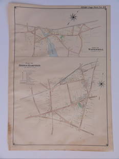
Sold2016Bridgehampton & Watermill, Long Island, 1902Original engraving published by E. Belcher Hyde from "Atlas of Suffolk County, Long Island, New York," Philadelphia, 1902. Map features family names, historic buildings and railroad routes. DimensionsSee Sold Price
Sold20231842 MATHER & SMITH WALL MAP OF LONG ISLAND, NYHand-colored lithograph. "A Geological Map of Long & Staten Islands with the Environs of New York"; William W. Mather, geologist and J. Calvin Smith, surveyor. This landmark pre-Civil War map is the eSee Sold Price
Sold20151830 Map of Long Island SoundFrom New York to Mantock Point; published by E. & G.W. Blunt, NY. Printed in three sheetes 24" x 8 1/2", pressure mounted and framed, 26 1/4" x 84 1/4".See Sold Price
Sold2017Buache: Antique Map of New York, Long Island, 1807Map: Ile de New-York Partie de Long-Island ou de l'Ile Longue et positions des armées Américaine et Britannique après le combat livré sur les hauteurs, le 27 Août, 1776. Maker: Buache, Jean NicolSee Sold Price
Sold2024Group of Ten Railroad Photographs, Maps, and Prints - New Jersey, Long Island, and New YorkGroup of Ten Railroad Photographs, Maps, and Prints - New Jersey, Long Island, and New YorkA mixed group of framed items for railroads in the New Jersey and New York area. Photographs include people oSee Sold Price
Sold2024(45)1930s-50s Road Maps, Railroad,More - 1944 New York Central & Long Island Railroad Time Tables,(45)1930s-50s Road Maps, Railroad,More - 1944 New York Central & Long Island Railroad Time Tables, Maps - NY, Ohio, Kentucky, Tennessee, Indiana, Kansas, New Jersey + MoreSee Sold Price
Sold2022Engraved Map of Battle of Long Island 1776Map (Paris: Dentu, 1807) - "Ile de New-York Partie de Long-Island ou de l'Ile Longue et positions des armées Américaine et Britannique après le combat livré sur les hauteurs, le 27 AoûtSee Sold Price
Sold2016Town of Southampton Map (North Haven & Art Village),Original engraving of Southhampton town, including Peconic Bay, Hobson Island and many landmarks & family names. Published by E. Belcher Hyde from "Atlas of Suffolk County, Long Island, New York," 190See Sold Price
Sold2017FW Falls Long Island NY Yard Long ChromolithographUNITED STATES, EARLY 20TH CENTURY A yard long chromolithograph of Long Island, New York after F.W Falls. The map illustrates the topography of Long Island, Manhattan, and Montauk giving a representatiSee Sold Price
Sold2023E. Belcher Hyde Map Co. - Maps of Suffolk, Group of 4Lot 49 E. Belcher Hyde Map Co. American Manufacturer (fl. c. 1880 - 1920) Maps of Suffolk, Group of 4 (1916) lithograph with hand coloring from Suffolk County 1916 Vol 2 Long Island, New York, includeSee Sold Price
Sold2022(NEW YORK -- WESTCHESTER COUNTY.) John Bute Holmes. Map of Edge-Water, Delancey's Neck, Long Island(NEW YORK -- WESTCHESTER COUNTY.) John Bute Holmes. Map of Edge-Water, Delancey's Neck, Long Island Sound Between the Villages of New Rochelle & Mamaroneck. To Be Sold at Auction by Anthony J. BleekerSee Sold Price
Sold2023E. Belcher Hyde Map Co. - Maps of Sag Harbor, Group of 2Lot 48 E. Belcher Hyde Map Co. American Manufacturer (fl. c. 1880 - 1920) Maps of Sag Harbor, Group of 2 (1916) lithograph with hand coloring from Suffolk County 1916 Vol 2 Long Island, New York 17 xSee Sold Price
Sold2018Double-Sided Printed Partial Mapof Long Island, New York, Baker Crowell, Inc., depicting Great Neck, Long Island Sight lines 24 1/2"h x 31 1/4"w By descent from the Estate of Robert Weeks DeForest and Emily Johnson DeForest.See Sold Price
Sold2020Nautical Map / Sea Chart, #1212 Eastern Long IslandDescription: Nautical Map / Sea Chart, United States East Coast, Connecticut - New York, Long Island Sound, Eastern Part, 12th edition feb 10 / 69 ; all measurements are approximate; Folded; ShippingSee Sold Price
Sold2023Dripps' Map of the Five Cities New York, Brooklyn, Long Island City 19th Century folding pocket mapA rare and scarce folding pocket map showing a "MAP OF THE CITIES OF NEW YORK, BROOKLYN, LONGISLAND CITY, JERSEY CITY & HOBOKEN" published by "M. DRIPPS, 103 FULTON ST. N. Y." with a catalogue of M. DSee Sold Price
Sold2023Map: United States– East Coast / Connecticut– New York/ Long Island Western PartDescription: United States– East Coast / Connecticut– New York/ Long Island Western Part. Published at Washington D.C. US Department of Commerce, National Oceanic Service. Measurement apSee Sold Price
Sold2023MAP: United States - East Coast. Connecticut - New York. Long Island Sound - Eastern PartDescription: United States - East Coast. . Connecticut - New York. Long Island Sound - Eastern Part. Published at Washington D.C. US Department of Commerce, Environmental Science services AdministratiSee Sold Price
Sold2021Nautical Map / Sea Chart, #362 Block Island Sound andDescription: Nautical Map / Sea Chart, United States East Coast, New York, Long Island, Block Island Sound and Gardiner's Bay, 6th edition, Feb 10/69; Shipping: $20; different rate to California, AlasSee Sold Price
Sold2024Antique 1883 Eldridge's Chart Long Island SoundAntique 1883 Eldridge's Chart Long Island Sound From Newport to New York by Geo. Eldridge, Hydrographer and Published by S. Thaxter & Son. The map is framed in a metal map frame with no glass. The mapSee Sold Price
Sold20181807 Marshall Map Showing New York City in 1776 -- IleTitle/Content of Map: 1807 Marshall Map Showing New York City in 1776 -- Ile de New-York. Partie de Long-Island ou de l'Ile Longue, et Positions des Armees Americaine et Britannique, apres le Combat LSee Sold Price
Sold2023MAP: United States - East Coast. Thames River New York London Harbor Long Island to NorwichDescription: United States - East Coast Connecticut - New York. Thames River/ New York London Harbor Long Island to Norwich. Published at Washington D.C. US Department of Commerce, Environmental ScienSee Sold Price
Sold20181776 Map of Country Round Philadelphia New JerseyA Map of the Country round Philadelphia including Part of New Jersey New York, Staten Island and Long Island, published for Gentleman's Magazine, London, 1776. Fine condition, folds as issued, measureSee Sold Price
May 24Eldred'sAMERICAN SCHOOL (Mid-20th Century,), "April Shore Bellport" (Long Island, New York)., Oil on board,US$70
May 26Santa Cruz Auction CompanyEdward Philip Browasky (1868-1939) Painting of Long Island 1918US$300