Sold2023Scarce vintage map of the Deep South, 1875J. David Williams’ map of southern states from the very scarce Jones & Hamilton Atlas of the World Illustrated. Shows the six states that comprise the extreme southeastern United States. WonderfullySee Sold Price
Sold2021Civil War era map of deep southern states, 1860/62Title: Civil War era map of deep southern states, 1860/62 Description: "Authentic vintage map of three deep south states whose partial borders are defined by the mighty Mississippi River, one of the gSee Sold Price
Sold2023Scarce early Cram RR map of the Deep SouthFrom a very scarce Cram atlas comes this map of the Deep South showing the areas railway system in place in 1882. ”New Railroad and County Map of Arkansas, Louisiana & Mississippi.” The 18See Sold Price
Sold2023Civil War era 1863 map of Mexico & Caribbean nationsLovely and vintage double-page map showing all of Mexico, Central America, Texas, Indian Territory and states of the Deep South during the middle of the American Civil War. Map has an 1860 copyright bSee Sold Price
Sold2021Large hand colored map of Asia, 1875Large vintage map of Asia in the not-often seen hand-colored version. Most likely drawn by A. K. Johnston, and appearing the very scarce Jones and Hamilton Atlas of the World Illustrated, published 18See Sold Price
Sold2023Map of N. Carolina from Gray’s National Atlas, 1875Map of North Carolina from the exceedingly scarce Gray’s National Atlas. Uncommon format highlighting North Carolina on its own (it’s usually paired with South Carolina). Topographical features arSee Sold Price
Sold2023Extremely scarce map of South Carolina (1814)Scarce third state of Samuel Lewis’s map of South Carolina, appearing in the extremely scarce 1816 edition of Carey’s General Atlas (same map as in the 1814 Carey atlas). One of the earlieSee Sold Price
Sold2017Meyer: Antique Pre-Civil War Map of Deep South, 1853Map: Die Staaten von Arkansas, Mississippi, Louisiana & Alabama Cartographer: Bibliographischen Instituts. Place & Date: Hildburghausen / 1853 Size: 10 5/8" x 7 7/8" Condition: original color; overallSee Sold Price
Sold2020Scarce “Four Corners” map, 1875Scarce map of the four corners states, hand colored by counties. Includes towns, mountains, rivers, Forts, Indian Villages, early railroads and proposed railroad routes, plus many other details. The eSee Sold Price
Sold2017Putnam: Vintage Pictorial Map of South California, 1963Title/Content of Map: 1963 Putnam Pictorial Map of Southern California -- Ride the Roads to Romance along the Gold Coast thru the Sunshine Empire of Southern California Date Printed: 1963, San BernardSee Sold Price
Sold2023South America. Second World War 1942 old vintage map plan chartTitle: South America. Second World War 1942 old vintage map plan chart Description: South America' by George Philip & Son (1942). Vintage colour map, 27.5 x 22.0cm, 10.75 x 8.5 inches Product InformatSee Sold Price
Sold2023South America. Second World War 1942 old vintage map plan chartTitle: South America. Second World War 1942 old vintage map plan chart Description: South America' by George Philip & Son (1942). Vintage colour map, 27.5 x 22.0cm, 10.75 x 8.5 inches Product InformatSee Sold Price
Sold2023SOUTH AMERICA. Britannica 9th edition 1898 old antique vintage map plan chartTitle: SOUTH AMERICA. Britannica 9th edition 1898 old antique vintage map plan chart Description: South America' by Britannica, Encyclopaedia (1898). Antique coloured map, 32.5 x 25.0cm, 12.75 x 9.75See Sold Price
Sold2020Scarce hand-colored map of Texas, 1875Attractive and scarce map of Texas with inset map "Western Part of Texas". Exquisite detail with counties painstakingly colored by hand. Interesting map of the growing state developed circa 1875 durinSee Sold Price
Sold2021Scarce RR map of Wisconsin, 1875Uncommon and large map of Wisconsin found only in the Wisconsin edition of the very scarce Jones and Hamilton Atlas of the World Illustrated, published 1875 by H. H. Hardesty. Huge top and bottom margSee Sold Price
Sold2022Scarce map N. England/Atlantic states, 1875Fully hand-colored map of the New England and Atlantic states. From the very scarce Jones and Hamilton Atlas of the World Illustrated published 1875 by H. H. Hardesty. This atlas was usually publishedSee Sold Price
Sold2024GROUP OF ANTIQUE AND VINTAGE MAPS, INC.. NORTH AND SOUTH AMERICA, WORLD MAPS, LOSSES THROUGHOUT,GROUP OF ANTIQUE AND VINTAGE MAPS, INC.. NORTH AND SOUTH AMERICA, WORLD MAPS, LOSSES THROUGHOUT, 19.5 X 26 LARGESTSee Sold Price
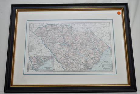
Sold2021HAMMONDS COMPLETE MAP OF SOUTH CAROLINAVintage Hammonds Complete Map of South Carolina. Showing all the railroad routes. c. 1930s. Professionally framed and matted. In frame measures 26 3/4"x20"x 1 1/4". Weight 7 pds. PROVENANCE: A PrivateSee Sold Price
Sold2023Collection of Maps on North & South AmericasA collection of vintage maps of North and South Americas, some old, some newer, some color, hand colored, and black and white, including Manhattan, United States, South America, and some Caribbean IslSee Sold Price
Sold2018Scarce 1875 hand-colored map of Texas by HardestyReserve Reduced! Attractive map of Texas and Indian Territory, colored by counties, from the very scarce Jones & Hamilton Historical Illustrated Atlas of the World published 1875 by H. H. Hardest. NicSee Sold Price
Sold2022Scarce map of NW territories, Hardesty 1875Scarce regional map of the Wyoming Territory, Montana Territory, Dakota Territory and Nebraska, colored by counties and showing towns, mountains, rivers, railroads, etc. One of the few maps to show WySee Sold Price
Sold2022Scarce Hardesty map of Southwest US, 1875Great map of the West, noting copper, silver and gold regions throughout southern Arizona and New Mexico. “Map of Colorado, Utah, New Mexico and Arizona,” by J. David Williams. Published 1875 by HSee Sold Price
Sold2016Map of South America by Colton, 1875Original engraving by Colton, 1875. Dimensions: 13 3/4" x 17 1/4" Shipping Domestic: Shipping rates are determind by destination. International: Foreign shipping rates are determined by destination. LSee Sold Price
4 days LeftJasper521775-1780 North & South Carolina, Georgia and Virginia. By Bonne & RaynalUS$180(2 bids)
21 hrs LeftNorthgate Gallery, Inc.Vintage Baker Furniture George II Style Wing Back Arm Chairs, PairUS$200
6 days LeftAkiba GalleriesVintage Louis Vuitton Printed Zebra Calf Skin & Wool Sweater- Size XLUS$175(4 bids)
22 hrs LeftBlack Hills Curio CompanyObsolete Vintage Rapid City South Dakota Police Badge No.55US$60(4 bids)
Jun 29Thomaston Place Auction GalleriesEARLY 18TH C. MONUMENTAL OIL PAINTING OF AN HISTORIC NAVAL ENGAGEMENT, ARTIST UNKNOWNUS$2,500
2 days LeftNoble House Collection GalleryA VINTAGE NATURAL CORAL NECKLACE DEEP SALMON 24" 31 GRAMSUS$60
2 days LeftNoble House Collection GalleryA FINE VINTAGE MID CENTURY RHINESTONE FLORAL NECKLACEUS$30(1 bid)