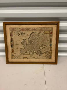
Sold2021Antique Framed Map of Europe, Europa Guilielmo BlaeuwAntique Color Map of Europe, Dutch Cartography. "Europa Recens Descripta" by Guilielmo Blaeuw, a cartographer for the Dutch East India Company. Lots of colorful detail of different nationalitiSee Sold Price
Sold2024Two (2) Antique 18th C. Copper Engraved Framed Maps - America & EuropeTwo (2) antique 18th C. copper engraved framed maps. One of Amerique and other titled Carte d'Europe. Both framed under glass. Frame Size: 13.5H x 14.5W (each)See Sold Price
Sold2022Three Framed Maps from the 19th-20th centuriesThree framed maps of Europe and Asia minor from the 19th-20 centuriesSee Sold Price
Sold2023ESTATE OF SEYMOUR STEIN: 4 SMALL FRAMED MAPS (2) OF EUROPE (1) OF N. AMERICA (1) OF ASIA 12" X 15"ESTATE OF SEYMOUR STEIN: 4 SMALL FRAMED MAPS (2) OF EUROPE (1) OF N. AMERICA (1) OF ASIA 12" X 15"See Sold Price
Sold20231769 ANTIQUE MAP of EUROPE framed EUROPEAN POSTAL ROADS & STATIONS1769 ANTIQUE MAP: MAPPA GEOGRAPHICA EXHIBENS POSTAS omnes tam vehiculares quam verdarias Totius Germaniae cum earum accurata distantia Diligentissime propriis sumptibus excudit. Aug. Vindelicor. : TobSee Sold Price
Sold2023Map of Europe, Framed and Under GlassMap of Europe, framed and under glass 24" x 29".See Sold Price
Sold2024Vintage William Blaeu Colored Map of EuropeVintage William Blaeu Colored Print Map of Europe, Framed. Measures 28 inches x 23 inches.See Sold Price
Sold2023Group of 4 Early European MapsGroup of 4 early framed European maps, including; 'De L'Europe, figure III., Isle D'Albion", 'Westmorland', 'Wien in Oesterreich' and 'Milan'. Measures: 12" x 15 1/2" overall, largest.See Sold Price
Sold20211861 Levasseur Hand Colored Map of Europe1861 Levasseur hand-colored map of Europe, well framed, overall 21 1/2" x 25"See Sold Price
Sold2016Early European Map, Artois, Later Edition of AntwerpEarly European Framed Map, Later edition of Antwerp and Western Europe, Artois, French Edition, by Johanne Surbonio Montenfi, after engraving by Abraham Ortelius after Iacobo Surbonio Montano, circa 1See Sold Price
Sold20212) STIELER & MITCHELL MAPS EUROPE, TURKEY & GREECE(lot of 2) Framed maps, including: (1) engraving with hand coloring on paper, German map of Europe, Turkey, Greece, and the Ionian Islands, from "Stielers Schul-Atlas," published by Justus Perthes, GoSee Sold Price
Sold2021(3) MAPS: UNITED STATES, MARTHA'S VINEYARD, EUROPE(lot of 3) Framed maps, including: (1) Martha's Vineyard, U.S. Geological Survey, sight: 10.25"h, 14.25"w, overall: 12"h, 16"w, (1) Hungarian map of Europe, sight: 8.25"h, 10"w, overall: 13.25"h, 15"wSee Sold Price
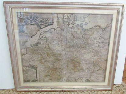
Sold2019(2) HAND-COLORED GERMANIC MAPS, NUREMBERG(lot of 2) Framed hand-colored engravings on paper, maps of Central Europe, including: (1) "Tabula Geographica: Principatus Gotha, Coburg et Altenburg," Johann Baptist Homann (1663-1724), Nuremberg, sSee Sold Price
Sold2016MAP OF EUROPE'EUROP, and the cheife Cities contaned therin', by John Speed, hand-colored engraving, London: Humber, 1626, framed, 18 x 22-3/4 in. (overall)See Sold Price
Sold20231782 COPPERPLATE ENGRAVED MAP OF EUROPEOriginal antique copperplate engraved map of “Europe” engraved for Baldwins New Complete and Universal System of Geography. Published by Thomas Conder circa 1782.Professionally framed andSee Sold Price
Sold20211813 Embroidered Map of EuropeTitle: 1813 Embroidered Map of Europe Dimension: 20 3/4" x 24 1/4" framed. Materials: Silk on wool Additional Information: G. Smerdon Embroidered Map of Europe Probably Southern English dated 1813 CarSee Sold Price
Sold2020Colored Engraving, Map of Europe, Eman BowerA New and Accurate Map of Europe, Eman Bower circa 1760, colored engraving. Custom burlwood frames by Giovanni Baccani, Florence, 15" x 18" unframed, 23" x 26" framed. Provenance: John's Island, VeroSee Sold Price
Sold2020Antique Map of Europe Glued on a CanvasAntique Map of Europe Glued on a Canvas. Beautifully Framed. Condition: Generally good. Dimensions: Sight- 36"x27", Frame- 43"x34". Provenance from a Long Island NY Estate. Please note the absence ofSee Sold Price
Sold2024Antique Europe Map/ France. Pieced down in sections. Sight size 26-1/2 x 36 inches. Overall framedAntique Europe Map/ France. Pieced down in sections. Sight size 26-1/2 x 36 inches. Overall framed size is 32 x 42 inchesSee Sold Price
Sold2016VINTAGE MAP OF EUROPE, WITH SCALE IN MILLIARIAVINTAGE MAP OF EUROPE, WITH SCALE IN MILLIARIA GERMANICA AND MILLIARIA ITALICA, FRAMED SIZE APPROX 14.25" X 19.75"See Sold Price
Sold20221763 LUDOVICI PHILIPPI MAP18th century original map of Europe titled ORBIS VETERIBUS NOTUS by Ludovici Philippi dated 1763. Auetor D'Anville. VG condition, no stains or tears. 21 x 29, framed 23 x 31 inches.See Sold Price
Sold202419th C. Relief Map of Africa, Central School Supply House ChicagoVictorian Relief Map of Africa, Europe, Central School Supply House Chicago. Framed colored map with raised 3D textured topographical details of Africa with parts of Europe and Asia presented as well,See Sold Price
Sold2022Set of Framed 19th C. Relief Maps (3)Printed in Chicago, 1893, set includes a framed relief map of the United States, a relief map of Europe, and a relief map of the world, 27" x 37 1/2" sight, 34" x 47 1/2" framed.See Sold Price
6 days LeftMark Louis Weseloh Estate LiquidationsSix - 17th c. Maps of Europe, Asia, England, Germany x2, Crete, Greece.8 1/4" x 6 5/8".US$300
Jun 07Freeman's | Hindman[MAP]. ORTELIUS, Abraham. Presbiteri Iohannis, sive, Abissinorum Imperii Descriptio. 1592.US$200
Jun 08OAB AuctionsGiorgio Baik Original Painting On Board Signed Framed Europe Waterscape ArtworkUS$175
Jun 09Worthington GalleriesAntique H/C Map EUROPE SOUS CHARLEMAGNE EN 814: EMPIRES D'OCCIDENT ET D'ORIENTUS$25
6 days LeftJasper521803 Poirson Map of Europe -- L'Europe divisee en ses Principaux Etats et d'apres le Traite de PaixUS$95
Jun 18DOYLE Auctioneers & AppraisersA block puzzle with maps of Europe, England, Ireland, Scotland, America and the WorldUS$100
Jun 30Global Auctions CompanyHand Colored Engraved Map of Europe, Jean Baptiste Bourguignon Anville 1754US$450


![[MAP]. ORTELIUS, Abraham. Romani Imperii Imago. 1592. (1 of 2)](https://p1.liveauctioneers.com/197/329395/177650537_1_x.jpg?height=282&quality=70&version=1715364962)
![[MAP]. ORTELIUS, Abraham. Presbiteri Iohannis, sive, Abissinorum Imperii Descriptio. 1592. (1 of 2)](https://p1.liveauctioneers.com/197/329395/177650536_1_x.jpg?height=282&quality=70&version=1715364962)


