Sold2024FRAMED WARREN COUNTY MAPWARREN CO., NEW JERSEY. MATTED AND FRAMED UNDER GLASS. 29 1/4" X 21 3/4". PLEASE READ CAREFULLY - Terms for Purchasing and Shipping of Auction Items. Please read carefully before bidding. All paymentsSee Sold Price
Sold20223 FRAMED CHARLESTON COUNTY MAPSThree (3) Framed Charleston County Maps showing Neighborhoods. Includes 1- The Peninsula of Charleston.2- East Cooper; Mt. Pleasant, Isle of Palms, Sullivans Island. 3- Sea Islands; Kiawah, Seabrook,See Sold Price
Sold2022Framed 1873 Columbia County MapFramed page from Columbia County Atlas, 1873, showing Malden Bridge, East Chatham, Chatham, Chatham Center, New Concord, and Claverack, 13 3/4" x 16 1/2" framed.See Sold Price
Sold20231876 Atlas of Illinois- Cook County Map Framed PagTravel back in time to the late 19th century with this enchanting Framed Map Page from the 1876 Atlas of Illinois by Warner & Beers. This exquisite piece showcases the detailed cartography of Cook, DuSee Sold Price
Sold20222 Topographical Maps of Warren County, New Jersey2 topographical maps of Warren County, New Jersey. Largest map: Sight: 23" x 15 1/4". Frame: 26 3/4" x 18 1/4" . Toning to both maps.See Sold Price
Sold2022FRAMED KENT COUNTY MD TOWN MAPS FROM ATLASALL MAPS FROM THE 1877 KENT COUNTY MD ATLASSee Sold Price
Sold2022Vintage 1950 Chas. E. Shannahan Talbot Co. Maryland Mapmeasuring 25" x 28" high framed 1950 Talbot County, Maryland Map mounted on linen with pencil notes written on right hand side. "Seats of Talbot County" #41 of 100 copies made.See Sold Price
Sold2021Framed 1850 County of Columbia, NY Map, Wingram Reissue1798 John Wigram map of Columbia County, New York. This is an 1850 reissue. Copy by David Vaughan on May 1850. This is a splendid map showing towns of Livingstone, Germantown and CleSee Sold Price
Sold20223 David Burr Maps Erie & Niagara County3 David Burr Maps Erie & Niagara County Framed - approx 25" x 21.5"See Sold Price
Sold2021Antique Framed Map of Columbia County, NY 1829Antique Framed Map of Columbia County, NY, dated 1829. Engraved by Rawdon Clark & Co, Albany, NY. Also marked Rawdon Wright, New York. Map includes locations of mills, churches and stage roads. NicelySee Sold Price
Sold2017Framed map of Chester County, Pennsylvania, copyright 1Framed map of Chester County, Pennsylvania, copyright 1938, compiled and drawn by Charles B MuthSee Sold Price
Sold2018FRAMED MAP OF CHESTER COUNTY 1847Framed Map Of Chester County 1847: Dated 1847. This map is adhered to a backing board. Projection and drawing by J.S Bowen, engraved by Edward Yeager of Philadelphia. 50"See Sold Price
Sold2020FRAMED 19th c. MAP-DUTCHESS COUNTY, 20" X 13"FRAMED 19th c. MAP-DUTCHESS COUNTY, 20" X 13"See Sold Price
Sold2022Map of Albany CountyFramed map of Albany County. Dated 1947. Overall 22" x 30 1/2".See Sold Price
Sold2018Mitchell: Antique County Map of Florida, 1870County Map of Florida The beautifully detailed and colored county map of Florida from the 1870 edition of Mitchell's popular New General Atlas of the world. Framed by the vine motif border typical ofSee Sold Price
Sold2024Vintage County Map Of NY State Plate EngravingMarked on lower left corner drawn and engraved by W.H. Gamble. Geographically map showing the state capitals, county towns, community towns, rail roads and canals in black and white. Framed in a tan tSee Sold Price
Sold20171862 Mitchell county map of Minnesota in near fineGreat chance to own an actual 150-year-old piece of history for a reasonable price. Beautiful and clean county map of Minnesota from Mitchell’s 1866 New General Atlas. When matted and framed, antiquSee Sold Price
Sold2022FRAMED NEW JERSEY PRINTDEPICTS "RES. OF HON. ABSALOM PURSEL, NEW VILLAGE, WARREN COUNTY, N.J." WALNUT FRAME. SIGHT VIEW 11 3/4" X 14 3/4" Please Read Carefully before Bidding. Hartzell’s Auction Gallery Inc. will CondSee Sold Price
Sold2018Mitchell: Antique County Map of Maine, 1870County Map of the State of Maine The beautifully detailed and colored county map of Maine from the 1870 edition of Mitchell's popular New General Atlas of the world. Framed by the vine motif border tySee Sold Price
Sold2018Mitchell: County Map of PennsylvaniaReserve Reduced! The beautifully detailed and colored county map of Pennsylvania from the 1870 edition of Mitchell's popular New General Atlas of the world. The map is framed by the vine motif borderSee Sold Price
Sold2017Three framed local maps including Dutchess County NY,Three framed local maps including Dutchess County NY, Putnam County NY, and a hand colored City of Poughkeepsie. All in good condition, late 19th to early 20th century.See Sold Price
Sold2021(NEW YORK.) David H. Burr. Hudson River & Vicinity.(NEW YORK.) David H. Burr. Hudson River & Vicinity. Engraved strip map of the Hudson River from lower Warren County to New York City. 24¾x4½ inches extended, folding into publisher's 12mo foSee Sold Price
Sold2018Cram Map of TexasCRAM, George F (1842-1928). Railroad and county map of Texas. Lithograph with handcolor, with original black slipcase on the verso. Chicago, 1876. 17 3/4 x 24 inches sheet, 28 x 33 inches framedSee Sold Price
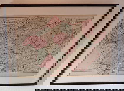
Jun 13Swann Auction Galleries(NEW JERSEY.) Group of 3 mid-nineteenth-century wall maps of Garden State counties.US$900
3 days LeftEarly American History Auctions1753 Map of the County of Lancaster Divided into its Hundreds, by Royal Mapmaker Emanuel BowenUS$280
3 days LeftEarly American History Auctions1836 Hand-Colored Map, Country Twenty Five Miles Round The City Of New-York Published by D.S. StoneUS$260
24 hrs LeftRapid Estate Liquidators and Auction GalleryFramed Collection Engravings & A Map From The Excursions In The County Of Sussex Published In 1822US$50
Jun 29Thomaston Place Auction GalleriesDATED 1815 PLATT SURVEY OF THE TOWN OF WALDOBOROUGH (NOW WALDOBORO) MAINE BY JOHN GLEASON, FRAMEDUS$200
3 days LeftTony Putty Artifacts4 3/16" Thebes Point. Beautiful Avon Chert. Warren County, IL.US$3,050(2 bids)
3 days LeftTony Putty Artifacts5 1/16" Trophy Axe. Green Porphyry. Warren County, OH. Ex Byron KnoblockUS$52(2 bids)
Jun 14DuMouchellesWilliam H. Gamble (American, B. 1863) Hand Colored Engraving, Ca. 1863, "County Map of Michigan AndUS$50(1 bid)
6 days LeftJasper521872 Mitchell Map of Massachussetts, Connecticut and Rhode Island -- County Map of Massachussetts,US$40
6 days LeftJasper521872 Mitchell Map of Louisiana, Arkansas and Mississippi -- County Map of the States of Arkansas,US$40
6 days LeftJasper521878 Mitchell Map of Georgia and Alabama -- County Map of the States of Georgia and AlabamaUS$50
3 days LeftRapid Estate Liquidators and Auction GalleryFramed Warren Kimble Red School House PrintUS$35