Sold2018Mitchell: County Map of PennsylvaniaReserve Reduced! The beautifully detailed and colored county map of Pennsylvania from the 1870 edition of Mitchell's popular New General Atlas of the world. The map is framed by the vine motif borderSee Sold Price
Sold2019Samuel Augustus Mitchell (1790-1868), "County Map ofSamuel Augustus Mitchell (1790-1868), "County Map of Pennsylvania, New Jersey, Maryland and Delaware," 1860, hand colored, H. -12 3/4 in., W. - 15 3/8 in.See Sold Price
Sold20221870 Mitchell Map of Pennsylvania -- County Map of theTitle: 1870 Mitchell Map of Pennsylvania -- County Map of the State of Pennsylvania Cartographer: S Mitchell Year/Place: 1870, Philadelphia Dimensions: 11.5 X 14 in. Description: This is a handsome maSee Sold Price
Sold2018Mitchell: Antique Map of Pennsylvania, 1870Title/Content of Map: 1870 Mitchell Map of Pennsylvania -- County Map of the State of Pennsylvania Date Printed: 1870, Philadelphia Cartographer: S Mitchell Size: 14 X 21.5 in. A very nice large, pastSee Sold Price
Sold20181878 Mitchell Antique Map of PennsylvaniaTitle/Content of Map: 1878 Mitchell Map of Pennsylvania -- County Map of the State of Pennsylvania Date Printed: 1878, Philadelphia Cartographer: S Mitchell Size: 13.5 x 21.3 in. A very nice, large maSee Sold Price
Sold20181860 S. MITCHELL JR. NORTHEAST STATES COUNTY MAP1860 S. Augustus Mithcell Jr. County map of Pennsylvania, New Jersey, Maryland and Deleware. Map measures approx. 11 1/4" height x 13 3/4" width to sight..See Sold Price
Sold2023County Map of the State of PennsylvaniaPublication Date: 1880 Title: County Map of the State of Pennsylvania Cartographer: GAMBLE, W. H. Publisher: S. Augustus Mitchell, Jr. Height: 14.6 Width: 21.25 Detailed map with pastel coloring. DoubSee Sold Price
Sold2021Pennsylvania 19th Century Maps (2)The first is a Pennsylvania, New Jersey, and Delaware folding map dated 1848 published by S. Augustus Mitchell with colored counties. It has close ups of Pittsburg, Lehigh & Schuylkill, Philadelphia,See Sold Price
Sold2017Mitchell: County Map of Texas, 1862County Map of Texas, S. Augustus Mitchell, 1862. 10.75 x 13.375 inches. Steel engraved map, with hand colored wash and outlines. Inset map of Galveston Bay, and Vicinity. Colored by county and territoSee Sold Price
Sold2023Samuel Augustus Mitchell 'County Map of...GA and AL'A Samuel Augustus Mitchell (American, 1792-1868) hand colored engraving titled 'County Map of the States of Georgia and Alabama' depicting the tri-state area of Georgia, Alabama and part of Florida anSee Sold Price
Sold20171862 Mitchell county map of Minnesota in near fineGreat chance to own an actual 150-year-old piece of history for a reasonable price. Beautiful and clean county map of Minnesota from Mitchell’s 1866 New General Atlas. When matted and framed, antiquSee Sold Price
Sold2018Mitchell: County Map of Kentucky & Tennessee, 1870Title/Content of Map: County Map of Kentucky and Tennessee Cartographer: S. A. Mitchell Place & Date: Philadelphia / 1870 Size: 13 3/8" x 9 3/4" Condition: full color; light overall age toning; slightSee Sold Price
Sold2018Mitchell: County Map of Quebec/Montreal InsetCartographer: S. A. Mitchell Place/Date: Philadelphia / 1870 Size: 13 1/4" x 10 3/4" Condition: full color; light overall age toning The beautifully detailed and colored county map of Quebec from theSee Sold Price
Sold2018Mitchell: County Map of Ohio and IndianaMap: County Map of Ohio and Indiana Cartographer: S. A. Mitchell Place/Date: Philadelphia / 1870 Size: 14" x 11 3/4" Condition: full color; light overall age toning The beautifully detailed and coloreSee Sold Price
Sold2018Mitchell: County Map of Iowa and MissouriMap: County Map of the States of Iowa and Missouri Cartographer: S. A. Mitchell Place/Date: Philadelphia / 1870 Size: 10 3/4" x 13 5/8" Condition: full color; light overall age toning The beautifullySee Sold Price
Sold2019Mitchell: County Map of Virginia and West VirginiaMap Title: County Map of Virginia and West Virginia Cartographer: S. A. Mitchell Place / Date: Philadelphia / 1870 Size: 14" x 11 5/8" Condition: full color; light overall age toning; tears and frayinSee Sold Price
Sold2016Mitchell: County Map of Florida 1867Map: County Map of Florida Maker: Mitchell Size: 11 x 13.25 inches Counties in original wash color. Inset of Mobile, AL. No Reserve: This lot starts at $1 and has no reserve as a courtesy so that collSee Sold Price
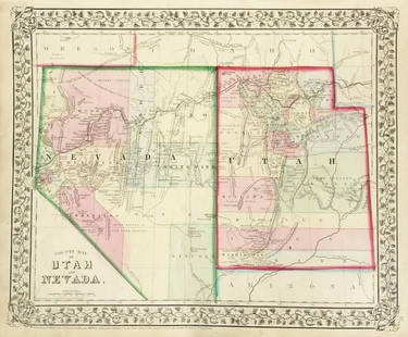
Sold2019Mitchell: County Map of Utah & NevadaMap Title: County Map of Utah and NevadaCartographer: S. A. Mitchell Place/Date: Philadelphia / 1870 Size: 14" x 11 5/8" Condition: full color; light overall age toning The beautifully detailed and coSee Sold Price
Sold2020Mitchell's County Map of the State of New York 1867Mitchell's County Map of the State of New York, 1867, S.Augustus Mitchell. Has some small tearing where the pages are joined but is in otherwise very good condition. Measures approx. 15" tall x 22" wiSee Sold Price
Sold2017Mitchell: Antique Map of Minnesota, 18621862 Mitchell county map of Minnesota in near fine condition. Great chance to own an actual 150-year-old piece of history for a reasonable price. Beautiful and clean county map of Minnesota from MitchSee Sold Price
Sold2017Mitchell: Antique County Map of Texas, 1873Excellent 1873 County Map of Texas by S. Augustus Mitchell. Impressive two-page County Map of the State of Texas. Map image much larger than earlier Mitchell maps. Designed and engraved by W. H. GamblSee Sold Price
Sold2019Samuel Augustus Mitchell (1790-1868), "County Map ofSamuel Augustus Mitchell (1790-1868), "County Map of the States of Georgia and Alabama," 1860, H.- 12 1/4 in., W.- 15 3/8 in.See Sold Price
Sold2017Mitchell: Antique County Map of Texas, 1870Map: County Map of Texas Cartographer: S. A. Mitchell Place & Date: Philadelphia / 1870 Size: 13 1/4" x 10 3/4" Condition: full color; light overall age toning The beautifully detailed and colored couSee Sold Price
Sold2018Mitchell: Antique County Map of Florida, 1870County Map of Florida The beautifully detailed and colored county map of Florida from the 1870 edition of Mitchell's popular New General Atlas of the world. Framed by the vine motif border typical ofSee Sold Price
6 days LeftJasper521860 Mitchell Map of Kentucky and Tennessee -- County Map of Kentucky and TennesseeUS$40
6 days LeftJasper521764 ACCURATE MAP OF THE COUNTY OF NORTHAMPTON antique 17.5 x 21.5" 18th CENTURYUS$75
6 days LeftJasper521869 Mitchell Map of South-Central Europe [verso] Asia -- XXXIV Austria, Switzerland, Italy, TurkeyUS$30
6 days LeftJasper521861 Mitchell Map of Washington DC -- Plan of the City of Washington The Capitol of the UnitedUS$70
6 days LeftJasper521869 Mitchell Map of Much of Western Europe -- XXXII Prussia the German States Holland & BelgiumUS$30
6 days LeftJasper521858 Mitchell Map of Great Britain and Ireland [verso] Germany and Switzerland -- No. 22 Map ofUS$25
6 days LeftJasper521858 Mitchell Map of Southern Europe and France [verso] Asia -- No. 24 Map of France, Spain,US$30


![1869 Mitchell Map of South-Central Europe [verso] Asia -- XXXIV Austria, Switzerland, Italy, Turkey (1 of 2)](https://p1.liveauctioneers.com/5584/328338/176911683_1_x.jpg?height=282&quality=70&version=1715113718)


![1858 Mitchell Map of Great Britain and Ireland [verso] Germany and Switzerland -- No. 22 Map of (1 of 2)](https://p1.liveauctioneers.com/5584/328338/176911589_1_x.jpg?height=282&quality=70&version=1715113718)
![1858 Mitchell Map of Southern Europe and France [verso] Asia -- No. 24 Map of France, Spain, (1 of 2)](https://p1.liveauctioneers.com/5584/328338/176911601_1_x.jpg?height=282&quality=70&version=1715113718)

