Sold2024Charleston Harbour map- Blunt 1833 mapCharleston Harbour map marked from New York published by E and G W. Blunt 1833. Engraved by William HookerSee Sold Price
Sold2019Edmond M. Blunt Map Dated 1806 Charleston Harbour12" x 16" under glass and is framed. Wear appropriate for ageSee Sold Price
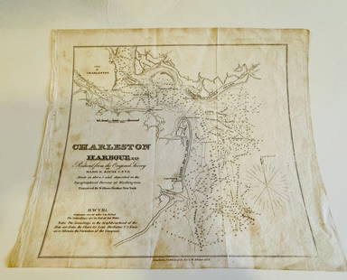
Sold2017Civil War Era Map of Charleston, SC and EnvironsE & G. W. Blunt's Map of Charleston and Vicinity (New York: E & G. W. Blunt, 1862), a handy map for military purposes showing both land and sea routes in the region. Unframed in a 1950s mailing/storagSee Sold Price
Sold202219th C Maps Isles of Shoals, Portsmouth NHPortsmouth NH maps, Dated 1816 Plan of Portsmouth Harbour published by Edmund M. Blunt NY 4.5" x 7.5". Dated 1841 hand colored map of the Isles of Shoals published by E & GW Blunt NY. 8.5" x 10.25".See Sold Price
Sold20171768 Millar Map of New York, Boston, Charleston,Title: 1768 Millar Map of New York, Boston, Charleston, Havana, Deleware River -- Plan of: the Harbour of New York; The Town and Harbour of Boston; River Deleware; Harbour of Charles Town; City and HaSee Sold Price
Sold2022A Plan of Charles Town the Capital of South Carolina… Charleston. LODGE 1780 mapTITLE/CONTENT OF MAP: 'A Plan of Charles Town the Capital of South Carolina, with the Harbour, Islands and Forts; the Attack on Fort Sulivan, by His Majesty's Ships under Sir Peter Parker, in 1776; thSee Sold Price
Sold20241817 Edmund M Blunt "Blunt's Stranger's Guide to the City of New-York"No Folding Map Compromising A Description of Public Building, Dwellings, Houses, including population, streets, markets, public amusements, the bay, the harbour, docks, slips, forts and fortificationsSee Sold Price
Sold20221833 MAP OF PALESTINE EMBROIDERED on COTTON GREEK UNIQUE antique JudaicaONE OF A KIND HAND EMBROIDERED COTTON GREEK MAP of PALESTINE Size 23 b 33 3/4" Some wear. Reserve: $1,050.00 Shipping: Domestic: Flat-rate of $25.00 to anywhere within the contiguous U.S. InternationaSee Sold Price
Sold20231833 MAP OF PALESTINE EMBROIDERED on COTTON GREEK UNIQUE antique JudaicaDescriptionONE OF A KIND HAND EMBROIDERED COTTON GREEK MAP of PALESTINESize 23 b 33 3/4"Some wear.Reserve: $1,000.00Shipping:Domestic: Flat-rate of $25.00 to anywhere within the contiguous U.S.InternaSee Sold Price
Sold2023Scarce and sharp 1833 map of Missouri, Anthony FinleyExtremely scarce map of Missouri from Anthony Finley’s 1833 New General Atlas. Osage, Kickapoo, Delaware and Shawnee tribes shown occupying most of the Ozark Mountains in the lower left quarterSee Sold Price
Sold20221833 map of N. Carolina from very scarce Finley atlasBeautiful, clean map of North Carolina from the extremely scarce 1833 edition of Anthony Finley’s New General Atlas. Shows coastal features, swamps, topographical rendering, roads, towns, islandSee Sold Price
Sold2023Beautiful and authentic antique 1833 map of Africa – FinleyScarce and lovely map of Africa that predates the mid-19th century explosion of European exploration of the continent (see large unexplored area in lower half of map). Shows the full continent from thSee Sold Price
Sold20231833 map of Mississippi shows Indian territory as half of stateAn important and historical map of Mississippi with counties named and in contrasting colors. This map is particularly important due to the rapidly changing American Indian situation in the northern pSee Sold Price
Sold20231833 map of Tennessee showing Cherokee TerritoryExcellent engraving with original hand coloring. Map of the state of Tennessee showing early county divisions. Published after the passage of the 1830 Indian Removal Act, but before the Cherokee RemovSee Sold Price
Sold2022Beautiful example of 1833 map of Ireland by A. FinleyAn excellent example of Finley’s map of Ireland with crisp ink impression and wonderful original hand coloring. Shows the divisions of the four provinces and each individual county. In addition,See Sold Price
Sold2022Great 1833 map of Kentucky by Anthony FinleyVery nice impression on this 190-year-old map. State maps from the later Finley atlases are rarely available. A lovely example with just a tiny repaired edge tear at top. Nice representation of mountaSee Sold Price
Sold2022Anthony Finley’s 1833 map of The WorldLovely example of Finley's attractive The World on Mercator's Projection, from his 1833 New General Atlas. The world’s continents are shown in clear detail, with many rivers, cities, coastal feaSee Sold Price
Sold2022Scarce 1833 map of West Indies – fine impressionTrue fully hand colored map of the Caribbean by Anthony Finley features the West Indies and Caribbean Islands. The map extends from southern Florida to northern South America and includes the Bahamas,See Sold Price
Sold2024Beautiful 1833 map of Egypt by Anthony FinleyScarce and lovely map of Egypt centered on the Nile River and showing the river settlements as far south as Assouan (Aswan). Shows the pyramids of Geeza and Saccara (Saqqara) and delineates what has bSee Sold Price
Sold2015MITCHELL UNITED STATES MAP 1833Hand colored map by J.H. Young, Phila. PA. Some spotting and light edge wear. 21 1/2'' x 17 1/4''See Sold Price
Sold20221833 map engraving of the Southern StatesTitle: 1833 map engraving of the Southern States Provenance/Additional Information: In an old painted black pine frame. Total framed size is approximately 6 1/2” x 8”. Condition: GC ShippiSee Sold Price
Sold20241833 Map of Pennsylvania, New Jersey, MaryLand, Delaware, Columbia and Part of VirginiaMap published by Baldwin and Cadock in 1833. Map measures approx 13 1/4" x 18" Overall good condition.See Sold Price
5 days LeftJasper52Carte des Royaumes de Belgique & Hollande. Belgium Netherlands. LAPIE 1833 mapUS$35
5 days LeftJasper52Chart of the Mediterranean Sea. Marseilles Genoa Gibraltar. THOMSON 1817 mapUS$260
5 days LeftJasper52A Chart of the Sea Coast from England to the Streights. MOUNT & PAGE 1758 mapUS$500
Featured5 days LeftJasper52MEDITERRANEAN PORTS. Marseille Gibraltar Valetta Naples Algiers Piraeus 1903 mapUS$30
22 hrs LeftTrillium Antique Prints & Rare BooksWebber & Cook, Rare - View of the Harbour of Taloo, in the Islands of EimeoUS$500
22 hrs LeftTrillium Antique Prints & Rare BooksKarl Bodmer - Saki Indian and Musquake Indian. 3US$300
22 hrs LeftTrillium Antique Prints & Rare BooksGould - Peacock Groove-bill Aracari or ToucanUS$100(1 bid)
May 18Trillium Antique Prints & Rare BooksKarl Bodmer - Bison-Dance of the Mandan Indians in front of their Medicine Lodge in Mih-TuttaUS$300
May 18Trillium Antique Prints & Rare BooksKarl Bodmer - The Elkhorn Pyramid on the upper Missouri. 21US$300
4 days LeftJasper521902 ACROSS COVETED LANDS JOURNEY to CALCUTTA INDIA 2 VOLS. antique ILLUSTRATEDUS$240