Sold20231833 map of Tennessee showing Cherokee TerritoryExcellent engraving with original hand coloring. Map of the state of Tennessee showing early county divisions. Published after the passage of the 1830 Indian Removal Act, but before the Cherokee RemovSee Sold Price
Sold2022WILLIAM H. LIZARS. MAP OF POLAND & LITHUANIA 1828Lizars, William Home. POLAND AND LITHUANIA (Edinburgh, ca. 1828). Engraved map showing territories of the formerPolish-Lithuanian Commonwealth, including Belarus and Latvia, large parts of Ukraine andSee Sold Price
Sold2023Western HemispherePublication Date: 1830 Title: Western Hemisphere Cartographer: HALL, SIDNEY Publisher: LONGMAN, REES, ORME, BROWN AND GREEN Height: 16 Width: 16 Detailed hemisphere map showing "Western Territories" aSee Sold Price
Sold2017Johnson: Antique Map of Australia, 1863Title/Content of Map: 1863 Johnson's Map of Australia -- Johnson's Australia Date Printed: 1863, New York Cartographer: A Johnson Size: 13.1 x 15.2 in. An eloquent map showing six territories of AustrSee Sold Price
Sold2017Johnson: Map of Australia, 18611861 Johnson's Map of Australia -- Johnson's Australia. An eloquent map showing six territories of Australia at the time: New South Wales, Victoria, Van Diemen Land, and West, North and South AustraliSee Sold Price
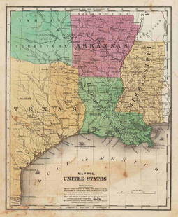
Sold20211847 map showing east Texas/Indian TerritoryInteresting map of the southern U. S. in 1847. Map by Cady & Burgess from Roswell SmithÂ’s 1847 Quarto Atlas. Eastern portion of Texas shown along with most of Indian Territory. Also includes ArkanSee Sold Price
Sold2023Original 1862 Civil War Map - WAR MAP OF KENTUCKY AND TENNESSEE, Harper's 1862Original 1862 Civil War Map - WAR MAP OF KENTUCKY AND TENNESSEE, SHOWING THE PRESENT THEATRE OF OPERATIONS IN THE WEST, Harper's Weekly, September 20, 1862. Approx. Size: 16" H x 10" W. Very nice cleaSee Sold Price
Sold2022County Map of Kentucky and Tennessee 1881Rare antique map of Kentucky and Tennessee showing counties, waterways, railroad routes and townships. "Entered according to Act of Congress in the year 1880 by S Augustus Mitchell in the office of thSee Sold Price
Sold2018Map of Palestine - Woodcut - Lyon, 1535Tabula Terre Sanctae. Map of Palestine. Woodcut from "Geographia" by Ptolemy Claudius, edited by Michael Servetus. [Lyon, 1535]. Map of Palestine, showing the territories of the Tribes of Israel. TheSee Sold Price
Sold20231833 map of Mississippi shows Indian territory as half of stateAn important and historical map of Mississippi with counties named and in contrasting colors. This map is particularly important due to the rapidly changing American Indian situation in the northern pSee Sold Price
Sold2018Map of the United StatesTitle/Content of Map: Map of the United States Date Printed: 1838 Cartographer: ANONYMOUS Material/Medium: Size: 11.6X14.5 Map showing topography, states, lg. MO territory, Northwestern territory (WI,See Sold Price
Sold2022Wonderful 1872 map of Alaska with orig. hand coloringVery nice and uncommon two-page map titled “Northwestern America showing the Territory ceded by Russia to the United States.” Map was published by H. H. Lloyd in 1872, just five years afteSee Sold Price
Sold2017Mitchell: Map of North Western America/Alaska, 1870Map: North Western America showing the territory ceded by Russia to the United States Cartographer: S. A. Mitchell Place & Date: Philadelphia / 1870 Size: 14 1/2" x 11 5/8" Condition: full color; lighSee Sold Price
Sold20211858 map of N. America showing Gold RegionsMap dated 1858 and found in an 1869 edition of Mitchell’s School Atlas. An early map showing Alaska as U. S. territory. Alaska labeled “Russia America; Ter’y of United States.”See Sold Price
Sold2018Johnson's North AmericaTitle/Content of Map: Johnson's North America Date: 1862 Cartographer: JOHNSON AND WARD Size: 21X15.3 Map showing lg. NM, DK & WA territories, AK is Russian Possession, U.S. Mail route, Indian tribes,See Sold Price
Sold2022Color map of S.F. showing water system 1908Heading: -1908 Author: Title: Map of San Francisco showing its uneven territory and the present and proposed main conduits reservoirs and pumping plants of the Spring Valley Water Co. 1908 Place PublSee Sold Price
Sold2016Map of Indian Territory and Oklahoma, J. Bein 1890Title: Map of Indian Territory and Oklahoma Subject: Oklahoma Maker: J. Bein Date: 1890, New York Size: 22.5 x 29.5 inches Map of the Indian Territory showing areas ceded to various tribes, each withSee Sold Price
Sold2021Scarce h/c map of Idaho, Cram 1882Early and scarce county map of Southern Idaho Territory showing limited railroads only in eastern portion of the state. One of them leads to and ends at Hailey, site of early silver mining (the map inSee Sold Price
Sold2021U. S. TERRITORY STILL UNDER INSURRECTIONARY CONTROLCivil War Dated Wood Engraved Map MAP SHOWING THE EXTENT OF UNITED STATES TERRITORY STILL UNDER INSURRECTIONARY CONTROL, Harper's Weekly, June 28, 1862 (Civil War, Confederate States, Rebels, SuccessiSee Sold Price
Sold2018Illman & Pilbrow Map of Oregon Territory, 1833David H. Burr (American, 1803-1875), "Oregon Territory", engraved by Illman & Pilbrow, 1833. Publisher - New York: D.S. Stone. Printed by Cammeyer & Clark, New York. According to the statement below tSee Sold Price
Sold2023Pictorial map of Oregon TerritoryHeading: (Oregon) Author: Ries, E. Karolyn Title: A map of the Oregon Country showing the Original Territory Place Published: No place Publisher: Date Published: No date [c.1930s] DescrSee Sold Price
Sold20181871 Mitchell Antique Map of AlaskaTitle/Content of Map: 1871 Mitchell Map of Alaska -- North Western America Showing the Territory Ceded by Russia to the United States Date Printed: 1871, Philadelphia Cartographer: S Mitchell Size: 11See Sold Price
Sold2022(CIVIL WAR.) P.S. Duval & Son. Military Map of the United States & Territories(CIVIL WAR.) P.S. Duval & Son. Military Map of the United States & Territories Showing the Location of the Military Posts, Arsenals, Navy Yards, & Ports of Entry. Hand-colored lithographed pocket mapSee Sold Price
Sold2023Scarce 1854 wall map of N. America in exceptional condition, Jacob MonkSurprisingly clean and sound wall map of North America showing significant evolution of territories west of the Mississippi River following the Mexican-American War and during the height of the CalifoSee Sold Price
Jun 12Dan Morphy AuctionsPLATE CXIII. MAP OF INDIAN TERRITORY SHOWING DISTRIBUTION OF WOODLAND” FROM THE TWENTY-FIRSTUS$100
Featured7 days LeftJasper52Johnson's New Military Map of the United States Showing the Forts, Military Posts &C. With EnlargedUS$65
Jun 08Connoisseur AuctionsEarly 1900's Railway Service Map, Illinois, Ohio, Indiana, Kentucky, TennesseeUS$20
7 days LeftJasper52No.4 Sketch D Showing the progress of Section No4 Southern Section No2 U.S. Coast Survey in 1845 46US$25
7 days LeftJasper52Sketch J No. 3 Showing the Progress of the Survey of Washington Sound and Vicinity ... 1855US$35
May 29Cedarburg Auction & Appraisals LLCSet of Four Maps Showing All of Spain and PortugalUS$25(1 bid)
7 days LeftJasper52Quarry Map Showing the Situation and Size of the More Important Slate Quarries in The "UnfadingUS$20
1 day LeftPotter & Potter AuctionsLISTER, James Wren (1897 – 1952). Avalon Town / Santa Catal...US$100(1 bid)
1 day LeftPotter & Potter AuctionsMcCARTY, Lea (1905 – 1960). Sonoma County / Its Highlights ...US$100(1 bid)
1 day LeftPotter & Potter AuctionsPan American Airways World System Map. 1956. Art by John Br...US$200
7 days LeftJasper521866 McNally Map of Huge Idaho, Dakota, Colorado, Nebraska, etc -- Nebraska, Kansas, Dakota,US$70
21 hrs LeftOriental Art AuctionsAL-IDRISI AND ROGER II, A MAP OF ASIA IN NUZHAT AL-MUSHTAQ, 17TH CENTURY€4,000
7 days LeftJasper52Sketch Showing the Progress of the Survey On The Atlantic, Gulf of Mexico and Pacific Coasts Of TheUS$25


![Map of Palestine - Woodcut - Lyon, 1535: Tabula Terre Sanctae. Map of Palestine. Woodcut from "Geographia" by Ptolemy Claudius, edited by Michael Servetus. [Lyon, 1535]. Map of Palestine, showing the territories of the Tribes of Israel. The](https://p1.liveauctioneers.com/1980/117218/60259208_1_x.jpg?height=310&quality=70&version=1520155929)


![Pictorial map of Oregon Territory: Heading: (Oregon) Author: Ries, E. Karolyn Title: A map of the Oregon Country showing the Original Territory Place Published: No place Publisher: Date Published: No date [c.1930s] Descr](https://p1.liveauctioneers.com/642/310901/166355373_1_x.jpg?height=310&quality=70&version=1701367957)


