Sold2021Framed 1822 French map of IndianaFramed 1822 French map of Indiana, shows Indian territories and 35 of the 92 counties, but it's in French! 25.5"H x 32"W overall in contemporary frameSee Sold Price
Sold20203 1/8" LONG AMAZING HEMATITE PLUMMET FOUND BY STANLY3 1/8" LONG AMAZING HEMATITE PLUMMET FOUND BY STANLY RAZMUS IN VERMILLION COUNTY INDIANA ON NOVEMBER 2ND, 1969, PICTURED IN "ARTIFACTS OF THE MIDWEST" PAGE 31, GREAT COLORFUL EXAMPLE, NATIVE AMERICANSee Sold Price
Sold20203 5/16" LONG HEMATITE PLUMMET FOUND BY STANLY RAZMUS IN3 5/16" LONG HEMATITE PLUMMET FOUND BY STANLY RAZMUS IN VERMILLION COUNTY INDIANA, PICTURED IN "ARTIFACTS OF THE MIDWEST" PAGE 31, GREAT EXAMPLE!See Sold Price
Sold2021Antique Framed Map of Columbia County, NY 1829Antique Framed Map of Columbia County, NY, dated 1829. Engraved by Rawdon Clark & Co, Albany, NY. Also marked Rawdon Wright, New York. Map includes locations of mills, churches and stage roads. NicelySee Sold Price
Sold2017Framed map of Chester County, Pennsylvania, copyright 1Framed map of Chester County, Pennsylvania, copyright 1938, compiled and drawn by Charles B MuthSee Sold Price
Sold2024Late 19th century watercolor on paper of Indiana counties mapLate 19th century watercolor on paper of Indiana counties map with county seats, overall 17"T x 13"WSee Sold Price
Sold20241870 Mitchell Map of Ohio and Indiana -- County Map of Ohio and IndianaTitle: 1870 Mitchell Map of Ohio and Indiana -- County Map of Ohio and Indiana Cartographer: S Mitchell Year / Place: 1870 Philadelphia Map Dimension (in.): 11.5 X 13.8 in. This is a very nice map ofSee Sold Price
Sold20231876 Atlas of Illinois- Cook County Map Framed PagTravel back in time to the late 19th century with this enchanting Framed Map Page from the 1876 Atlas of Illinois by Warner & Beers. This exquisite piece showcases the detailed cartography of Cook, DuSee Sold Price
Sold2018FRAMED MAP OF CHESTER COUNTY 1847Framed Map Of Chester County 1847: Dated 1847. This map is adhered to a backing board. Projection and drawing by J.S Bowen, engraved by Edward Yeager of Philadelphia. 50"See Sold Price
Sold20241876 Mitchell Map of Ohio and Indiana -- County Map of Indiana and OhioTitle: 1876 Mitchell Map of Ohio and Indiana -- County Map of Indiana and Ohio Cartographer: S Mitchell Year / Place: 1876 Philadelphia Map Dimension (in.): 11.5 X 13.8 in. This is a very nice map ofSee Sold Price
Sold2022Map of Albany CountyFramed map of Albany County. Dated 1947. Overall 22" x 30 1/2".See Sold Price
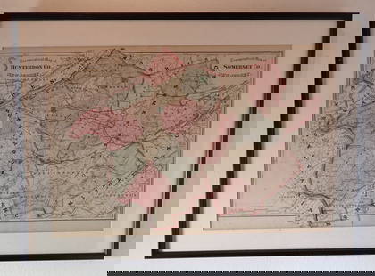
Sold2024FRAMED WARREN COUNTY MAPWARREN CO., NEW JERSEY. MATTED AND FRAMED UNDER GLASS. 29 1/4" X 21 3/4". PLEASE READ CAREFULLY - Terms for Purchasing and Shipping of Auction Items. Please read carefully before bidding. All paymentsSee Sold Price
Sold2017Three framed local maps including Dutchess County NY,Three framed local maps including Dutchess County NY, Putnam County NY, and a hand colored City of Poughkeepsie. All in good condition, late 19th to early 20th century.See Sold Price
Sold20223 FRAMED CHARLESTON COUNTY MAPSThree (3) Framed Charleston County Maps showing Neighborhoods. Includes 1- The Peninsula of Charleston.2- East Cooper; Mt. Pleasant, Isle of Palms, Sullivans Island. 3- Sea Islands; Kiawah, Seabrook,See Sold Price
Sold2020FRAMED 19th c. MAP-DUTCHESS COUNTY, 20" X 13"FRAMED 19th c. MAP-DUTCHESS COUNTY, 20" X 13"See Sold Price
Sold2022Framed 1873 Columbia County MapFramed page from Columbia County Atlas, 1873, showing Malden Bridge, East Chatham, Chatham, Chatham Center, New Concord, and Claverack, 13 3/4" x 16 1/2" framed.See Sold Price
Sold2021FRAMED 1891 MAP OF ULSTER + DUTCHESS COUNTIES, 20" XFRAMED 1891 MAP OF ULSTER + DUTCHESS COUNTIES, 20" X 30.25"See Sold Price
Sold2018Mitchell: Antique Map of Indiana and Ohio, 1860Title/Content of Map: 1860 Mitchell Map of Indiana and Ohio -- County Map of Ohio and Indiana Date Printed: 1860 Philadelphia Cartographer: S Mithchell Size: 10.5 x 13.2 A very nice county map of OhioSee Sold Price
Sold2024County Map of Ohio, and Indiana.Title: County Map of Ohio, and Indiana. Publication Date: 1861 Cartographer: MITCHELL, SAMUEL AUGUSTUS (JR.) Publisher: S. Augustus Mitchell, Jr. Height: 10.5 Width: 13.25 Map 31 from Mitchell's New GSee Sold Price
Sold2018Mitchell: County Map of Ohio and IndianaMap: County Map of Ohio and Indiana Cartographer: S. A. Mitchell Place/Date: Philadelphia / 1870 Size: 14" x 11 3/4" Condition: full color; light overall age toning The beautifully detailed and coloreSee Sold Price
Sold2019President James Polk Sign and Framed Land GrantNicely framed original land grant from Floyd's County, Indiana. Ink has faded.See Sold Price
Sold2023Antique Map County of Cumberland EnglandAntique Framed and Hand Colored Map of the County of Cumberland, England by Richard Blome (London Engraver 1600-1705) . 16 inches x 13 inchesSee Sold Price
20 hrs LeftRapid Estate Liquidators and Auction GalleryVintage Framed Map of Windsor, ConnecticutUS$80
Swann Auction GalleriesSwisshelm, Jane Grey Cannon (1815-1884) Autograph Letter Signed, Zozonia, [Indiana County, PennsylvaUS$175
May 22Thomaston Place Auction GalleriesFRAMED HANDCOLORED MAP OF AUSTRALIA BY JOHNSON & WARD, 1863US$150
2 days LeftJasper521860 Mitchell Map of Kentucky and Tennessee -- County Map of Kentucky and TennesseeUS$40
May 22Thomaston Place Auction GalleriesCOLLECTION OF TRAVEL EPHEMERA, BROCHURES, BOOKLETS, MAPS 1900-1950US$100
2 days LeftJasper521865 Johnson Map of Arkansas, Mississippi and Louisiana -- Johnson's Arkansas, Mississippi andUS$60