Sold20241856 ARCTIC EXPLORATIONS 2nd GRINNEL EXPEDITION 2 v. E.KANE antique ILLUSTRATEDArctic Explorations: The Second Grinnell Expedition. By Elisha Kent Kane. Philadelphia, 1856 Size 5 3/4 by 9 1/4" 2 volumes set Illustrations and maps (2 are folding.) Early 3/4 morocco, intact. VerySee Sold Price
Sold20241757 George Shelvocke "A Voyage Around the World by the Way of the Great South Sea"2nd revised edition Performed in a private expedition during the war, which broke out with spain in the year 1718 with 2 maps and illustrationSee Sold Price
Sold2018The South Pole. An Account of the Norwegian AntarcticThe South Pole. An Account of the Norwegian Antarctic Expedition in the "Fram," 1910-1912. With maps and numerous illustrations. 2 volumes. Frontispiee, xxxv, 392p, illustrations, map; frontispiece, xSee Sold Price
Sold2023Lot of 2 Africa, Asia Maps 1808-1809. Size 13 1/2 x 10 1/2 inches lengthLot of 2 Africa, Asia Maps 1808-1809. Size 13 1/2 x 10 1/2 inches length. The map shows Africa way before the infamous expedition by John Hanning Speke to the source of the Nile.See Sold Price
Sold2015History of Napoleon's Expedition to Russia - SegurHeading: Author: Segur, Philip de Title: History of Napoleon's Expedition to Russia Place Published: London Publisher:Treuttel and Wurtz Date Published: 1827 Description: 2See Sold Price
Sold20182 Books incl: The Expedition To Borneo..., 1846.[Indonesia] 2 Titles. ++ Sketches, Civil And Military, Of The Island Of Java And Its Immediate Dependencies… Lon: J. J. Stockdale, 1812. Folding map. 8vo. Polished calf. ++ The Expedition To BorneoSee Sold Price
Sold2016Scott - The Voyage of the "Discovery", 2 vol., second( Capt. Robert Falcon) The Voyage of the "Discovery", 2 vol., second impression, plates and maps, foxing, original cloth, rubbed, 1905; Scott's Last Expedition, 2 vol., second edition, plates and mapsSee Sold Price
Sold2018WERNE, Ferdinand (1800-1874). Expedition to discoverWERNE, Ferdinand (1800-1874). Expedition to discover the sources of the White Nile, in the years 1840, 1841. London: Richard Bentley, 1849. 2 volumes, 8vo (201 x 118 mm). Folding route map, lithographSee Sold Price
Sold2018Arctic Explorations: the Second Grinnell Expedition inArctic Explorations: the Second Grinnell Expedition in Search of Sir John Franklin, 1853, '54, '55. In 2 volumes. Volume 1, engraved frontispiece portrait and title page (1856), 464p, map, fold-out maSee Sold Price
Sold2023RARE: Hand Quilled & Draw Railroad Deeds Maps (2) Parts H 17 1/2 x L 25 x D 6’ inches. 225Parts H 17 1/2 x L 25 x D 6’ inches. 225 Pages These pages are all Hand Drawn , quilled & Colored listing the property owners as the train would make its journey going accross country. Each pagSee Sold Price
Sold20231788 VOYAGE TO AMERICA by F. CHASTELLUX antique ILLUSTRATED w / MAPS 2 VOLUMESVOYAGES DANS L'AMÉRIQUE SEPTENTRIONALE, DANS LES ANNÉES 1780, 1781 & 1782 2 volumes by CHASTELLUX, François-Jean de Paris; 1788-1791 8vo: 5 1/4 by 8 1/4" [8]-408, [4]-251 pp. Second autSee Sold Price
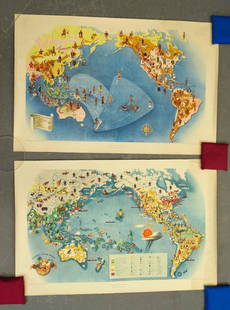
Sold2021Covarrubias Pacific Asia Pictorial Maps (2)Maps of the Pacific, Golden Gate International Exposition. NY, 1942. Miguel Covarrubias (1904-1957). 2 Maps: Peoples and Economy. Australia, Hawaii, Asia, Americas. .See Sold Price
Sold2018MAPS: (2) 1851 Rapkin Tallis U.S. & N. AmericaMAPS: (2) 1851 Rapkin Tallis U.S. & N. America, Pair of maps Drawn & Engraved by J. Rapkin, published by J & F Tallis, London, Edinburgh & Dublin, with illustrations by J. Marchant engraved by J. RogeSee Sold Price
Sold2016Medical anatomy maps (2), Denoyer-Geppert Co.-Chicago,Medical anatomy maps (2), Denoyer-Geppert Co.-Chicago, IL, Anatomy of Head, Neck, Throat & Skin, Exc cond & skeleton & musculature (front view), canvas pull down, staining in LR corner, 78"H x 41"W.See Sold Price
Sold2018MAPS: (2) U.S. Regional 1846 Meyer's AtlasMAPS: (2) U.S. Regional 1846 Meyer's Atlas, Pair of United States regional maps. Framed, sizes given are area inside mat followed by overall framed size. Both from Meyer's Universal Atlas and marked SSee Sold Price
Sold20221857 Arctic Explorations Voyage Elisha Kane Franklin Expedition Maps Illustrated1857 Arctic Explorations Voyage Elisha Kane Franklin Expedition Maps Illustrated The Arctic Exploration, or Advance, led by Elisha Kent Kane, was financed to find Sir John Franklin and his ship whichSee Sold Price
Sold2016Medical anatomy maps (2), Denoyer-Geppert Co.-Chicago,Medical anatomy maps (2), Denoyer-Geppert Co.-Chicago, IL, Anatomy of Urogenital System & Anatomy of Male & Female Pelvis, canvas, Exc cond, 78"H x 41"W.See Sold Price
Sold2021Pennsylvania 19th Century Maps (2)The first is a Pennsylvania, New Jersey, and Delaware folding map dated 1848 published by S. Augustus Mitchell with colored counties. It has close ups of Pittsburg, Lehigh & Schuylkill, Philadelphia,See Sold Price
Sold2023French Maps (2), French EmpireFrench maps (2), depicting the French Empire and chateaux of the Loire Valley sight: 13.5 x 18.5 in, frame: 16.5 x 22 in. Provenance: A San Antonio, Texas collection We happily provide seamless shiSee Sold Price
Sold2021World War II Pictorial Battle Maps (2)VII Corps. With XIX Corps in Action From Secured Line to Victory. 2 WWII European theater maps, American troops and allies, movements with illustrations. Sights 20 1/2" x 27 1/2", overall 22" x 29".See Sold Price
Sold2023French Maps (2), Astrology ChartFrench maps (2) to include astrology chart as well as map of modern France sight: 13.5 x 18.5 in., frame: 16.5 x 22 in. Provenance: A San Antonio, Texas collection We happily provide seamless shippSee Sold Price
Sold2023ESTATE OF SEYMOUR STEIN: 4 SMALL FRAMED MAPS (2) OF EUROPE (1) OF N. AMERICA (1) OF ASIA 12" X 15"ESTATE OF SEYMOUR STEIN: 4 SMALL FRAMED MAPS (2) OF EUROPE (1) OF N. AMERICA (1) OF ASIA 12" X 15"See Sold Price
1818 AuctioneersPolar Travel. Huxley, Leonard (ed.) - Scott's Last Expedition. London: Smith, Elder & Co., 1913.£30
1818 AuctioneersPolar Travel. North-West Passage. Two titles: The Search for Franklin. A Narrative of the American£16
2024Rapid Estate Liquidators and Auction GalleryUS Post Lewis And Clark First Day Stamp Sheet BundleSee Sold Price
Jun 12Dan Morphy AuctionsLOT OF 2 MAPS: LANDS IN THE COUNTIES OF RUNNELS & TOM GREEN RUNNELS COUNTY TEXAS MAPS.US$200
May 22The Benefit Shop Foundation Inc.2 Illustrated Coffee Table Bks WWII, Pugent Sound, SgnUS$1(1 bid)
14 hrs LeftHunt and Peck Estate Services, Inc.1713 Tho. Brodrick "A Compleat history of the late war in the netherlandsUS$50
May 30NY Elizabeth 1792 OLD INDIA HISTORY ANTIQUE ILLUSTRATED WITH MAPS OF THE EIGHTEENTH CENTURY IN FRENCHUS$50
6 days LeftJasper521654 HISTORY FRANCE D. BLONDEL Genealogiae Francicae VELLUM antique FOLIO MAPSUS$400
14 hrs LeftRapid Estate Liquidators and Auction GalleryDoughboys The Story of the AEF 1917-1918 HardcoverUS$35
6 days LeftJasper521902 ACROSS COVETED LANDS JOURNEY to CALCUTTA INDIA 2 VOLS. antique ILLUSTRATEDUS$240
8 hrs LeftForum AuctionsGolden Cockerel Press.- Lawrence (T.E.) Crusader Castles, 2 vol., one of 1000 copies, 1936.£100
May 22Thomaston Place Auction Galleries(38) LITHO BOOKPLATES OF TRAVEL IN JAPAN, 19TH C. BOOK ILLUSTRATIONSUS$100
6 days LeftJasper521868 - 1927 HISTORY OF MONGOLS Kalmuks Tartars of Russia & Central Asia antiqueUS$500
14 hrs LeftHunt and Peck Estate Services, Inc.Rare 1848 General Cass and Butler Presidential Democratic Campaign TicketUS$1,700(3 bids)


![Stansbury's Expedition Maps, 2 [169009] First Image](https://p1.liveauctioneers.com/2699/299063/159201772_1_x.jpg?height=300&quality=1&version=1692045182&width=300)
![Stansbury's Expedition Maps, 2 [169009] First Image](https://p1.liveauctioneers.com/2699/299063/159201772_1_x.jpg?height=300&quality=95&version=1692045182&width=300)


![2 Books incl: The Expedition To Borneo..., 1846.: [Indonesia] 2 Titles. ++ Sketches, Civil And Military, Of The Island Of Java And Its Immediate Dependencies… Lon: J. J. Stockdale, 1812. Folding map. 8vo. Polished calf. ++ The Expedition To Borneo](https://p1.liveauctioneers.com/179/117971/60557799_1_x.jpg?height=310&quality=70&version=1520636872)


![1788 VOYAGE TO AMERICA by F. CHASTELLUX antique ILLUSTRATED w / MAPS 2 VOLUMES: VOYAGES DANS L'AMÉRIQUE SEPTENTRIONALE, DANS LES ANNÉES 1780, 1781 & 1782 2 volumes by CHASTELLUX, François-Jean de Paris; 1788-1791 8vo: 5 1/4 by 8 1/4" [8]-408, [4]-251 pp. Second aut](https://p1.liveauctioneers.com/5584/304737/162633733_1_x.jpg?height=310&quality=70&version=1696971416)