Sold2023NORTH AFRICA BARBARY. Tripoli Libya Egypt coast Alexandria Tobruk. SDUK 1874 mapTITLE/CONTENT OF MAP: 'NORTH AFRICA OR BARBARY, V., PARTS OF TRIPOLI AND EGYPT' DATE PRINTED: 1874 IMAGE SIZE: Approx 34.0 x 42.5cm, 13.25 x 16.75 inches (Large) TYPE: Antique steel engraved map withSee Sold Price
Sold20181714 Moll Map of North Africa -- The East Part ofTitle/Content of Map: 1714 Moll Map of North Africa -- The East Part of Barbary Containing Tunis, Tripoli. Barca, Egypt, Nubia, Part of Biledul… Date: 1714 c., London Cartographer: H Moll Size: 6.9See Sold Price
Sold2020THEODORE GUDIN'S 19TH CENTURY PAINTINGTheodore Gudin was a French 19th Century painter who was born in 1802. Theodore Gudin is featured in Sotheby's Annual Orientalist Sale, Features Paintings Representing North Africa, Egypt, Arabia, theSee Sold Price
Sold2020[Maps & Atlases] [Africa] Ortelius, Abraham, Group of 2[Maps & Atlases] [Africa] Ortelius, AbrahamGroup of 2 MapsBarbariae et Biledulgerid, nova descriptio(Antwerp, ca. 1570-1612). Hand-colored engraving. Coastal map of North Africa and the Mediterranean,See Sold Price
Sold2024Map of the North Parts of America Claimed by France by Herman Moll (London, 1720)Map of the North Parts of America Claimed by France by Herman Moll (London, 1720) "A New Map of the North Parts of America claimed by France under ye Names of Louisiana, Mississippi, Canada, and New FSee Sold Price
Sold2022MOLL, HERMAN. A New Map of the North Parts of America claimed by France under ye Names of Louisiana,MOLL, HERMAN. A New Map of the North Parts of America claimed by France under ye Names of Louisiana, Mississipi, Canada and New France with ye Adjoyning Territories of England and Spain. Large engraveSee Sold Price
Sold2017Engraved Map, Renold ElstrackeRenold Elstracke (British, 1590-1630), "The North part of America," 1625, copper engraved map with had coloring, image: 11.25"h x 14."w, overall (with frame): 18.25"h x 22.25"w Likely a 20th century rSee Sold Price
Sold20201761 MAP OF NORTH AMERICA BY ROCQUE18th century map GENERAL MAP OF NORTH AMERICA 1754-1761 by John Rocque, London by A. Drury, 2 part map, 35.5 x 36 inches, good condition.See Sold Price
Sold2020Ait Ouaouzguite RugSecond quarter 20th century, 236 x 137 cm, North Africa, southern Morocco Comparatively fine in weave, this Berber rug is the work of the Ait Ouaouzguite tribe of the High Atlas region. The blue fieldSee Sold Price
Sold2017World.- SDUK Atlas.- Maps of the Society for theWorld.- SDUK Atlas.- Maps of the Society for the Diffusion of Useful Knowledge, 4 parts in 1, parts 1-2 with 207 engraved maps, hand-coloured in outline, a few double-page, part 3 "Stars" with 6 hand-See Sold Price
Sold20201802 Denon Atlas of Egypt Containing Maps, Views, etc.Title: 1802 Denon Atlas of Egypt Containing Maps, Views, etc. -- Planches du voyage dans la Basse et la Haute Egypte Date: 1802 c., Paris Cartographer: D-V Denon Size: 18.2 X 11.4 in. and lagest foldoSee Sold Price
Sold2022Map AssortmentMap Assortment (4) items including 'A New Map of Part of the United States of North America, Exhibiting The Western Territory' by John Carey, London 1805; 'Geographical, Statistical and Historical MapSee Sold Price
Sold2023Early Map of Tennessee, Daniel Smith, 1795A MAP OF THE TENNASSEE [sic] GOVERNMENT FORMERLY PART OF NORTH CAROLINA TAKEN CHIEFLY FROM SURVEYS BY GENL. D. SMITH & OTHERS, drawn by Daniel Smith, engraved by Joseph T. Scott, for "General Atlas FoSee Sold Price
Sold2022Audubons Octavo Quadrupeds in Original PartsAUDUBON, John James (1785-1851). The Quadrupeds of North America. New York: V.G. Audubon, 1849-1854. First octavo edition. Comparable: Christie's, William Reese Sale, 2022 - $20,160. IN ORIGINAL PARTSSee Sold Price
Sold2016Map of North America...David H. Vance, engraved by J.H. Young. Philadelphia: Anthony Finley, 1825. Engraved map in 5 parts with original hand color in outline. 25 7/8 x 20 1/2 inches sheet, 30 5/8 x 25 1/2 inches framed.See Sold Price
Sold20222-sheet map of ancient Egypt by Ortelius 1584Heading: Author: Ortelius, Abraham Title: Aegyptus Antiqua Place Published: Antwerp Publisher: Date Published: 1584 Description: Copper engraved map on two sheets, north anSee Sold Price
Sold2022London.- Booth (Charles) Descriptive Map of London Poverty 1889, in four parts, 1889London.- Booth (Charles) Descriptive Map of London Poverty 1889, in four parts covering the North-Western, South-Western, North-Eastern, and South Eastern parts of London, based on Stanford's 'LibrarySee Sold Price
Sold2022(BULGARIA.) A. Krivoshiev; Freytag & Berndt. [Map of Bulgaria with Adjacent Countries].(BULGARIA.) A. Krivoshiev; Freytag & Berndt. [Map of Bulgaria with Adjacent Countries]. Massive color-printed Bulgarian-language map of the Baltic nation with parts of Turkey, Greece, North Macedonia,See Sold Price
Sold2018David Roberts lithograph "Part of the Portico of Edfou,Medium: lithograph. This is one of the famous David Roberts lithographs from the Egypt & Nubia suite, printed in 1846 and published by F. G. Moon of Threadneedle Street, London. The lithography was doSee Sold Price
Sold2018AFTER NICOLAS SANSON (FRENCH, 1600-1667) MAP OF NORTHAFTER NICOLAS SANSON (FRENCH, 1600-1667) MAP OF NORTH AMERICA, hand-colored, on laid paper, title in cartouche to upper left corner lettered "NORTH AMERICA / Divided into it's Principall Parts / whereSee Sold Price
Sold2017Levasseur: Antique Map of North America, 1840Title/Content of Map: 1840 Levasseur Map of North America - Amerique Septrentionale Date Printed: 1840 Paris Cartographer: V. Levasseur Size: 11 x 16.5 in. Condition: Excellent. Minor age toning; issuSee Sold Price
Sold2021FRAMED J.H. COLTON MAP OF NORTH AMERICA CA INSETFramed engraving on paper, Map of North America from the Latest Authorities, published by J.H. Colton (Joseph Hutchins Colton, 1800-1893), No. 86 Cedar St., New York, 1846, drawn and engraved by J.M.See Sold Price
Sold2018ANTONIO ZATTA (ITALIAN, 18TH CENTURY) MAP / ATLAS OFANTONIO ZATTA (ITALIAN, 18TH CENTURY) MAP / ATLAS OF NORTH AMERICA, SET OF 12, hand-colored, on laid paper, comprising title page lettered in part "LE / COLONIE UNITE / DELL' / AMERICA SETTENTR'LE." aSee Sold Price
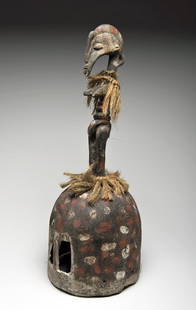
Sold201620th C. Senufo Helmet Mask Headdress, ex-MuseumWest Africa, Ivory Coast / Côte d’Ivoire, Senufo tribe, ca. mid 20th century CE. Elaborate assemblages of male figure with fiber around his legs and his shoulder. The mask plays a part at the buriaSee Sold Price
May 12Schilb Antiquarian Rare Books1859 AFRICA VOYAGES Barth Timbuktu Tripoli SLAVES Illustrated Slavery MAP AfricanUS$62(4 bids)
May 15University ArchivesScarce Early Printing: "An Account of the European Settlement in America in 6 Parts..."US$100
4 days LeftRail & Road AuctionsChicago, North Shore & Milwaukee Railroad North Shore Line Playing Cards CompleteUS$50
4 days LeftRail & Road AuctionsChicago, North Shore & Milwaukee Railroad North Shore Line Playing Cards CompleteUS$50
May 12Schilb Antiquarian Rare Books1869 ATLAS 42 MAPS America Africa Australia GERMANY Switzerland Sydow RAREUS$155(4 bids)
4 days LeftHunt and Peck Estate Services, Inc.1836 Paris M. Davis 1st "An Authentic History of the Late War Between the United States and GreatUS$50
16 hrs LeftCurated Gallery AuctionsLudwig Heitmuller (1863-1933) "Early Morning" Antique American Impressionist Seascape Oil PaintingUS$70(2 bids)
10 hrs LeftWoodcliff on The HudsonHudson Bay - Silver Cross and Otter on Trade Bead NecklaceUS$275(4 bids)
10 hrs LeftWoodcliff on The HudsonHudson Bay - Bronze 1880 Peace Medal on a Trade Bead NecklaceUS$225(5 bids)
10 hrs LeftWoodcliff on The HudsonHudson Bay - Huge Silver Cross Pendant with Central HB Logo Under Large Glass BeadUS$350(4 bids)
10 hrs LeftWoodcliff on The HudsonHudson Bay - Large Silver Decorated Cross on a Trade Bead NecklaceUS$300(3 bids)
10 hrs LeftWoodcliff on The HudsonHudson Bay - Silver Triple Cross on a Trade Bead NecklaceUS$150(2 bids)
May 19Ukiyoe Gallery Japanese Woodblock PrintsYoshida Hiroshi: Soshu 1940 JIZURI WoodblockUS$550(2 bids)
5 days LeftMynt Auctions1949 Sugar Bowl Full Ticket Oklahoma Sooners v North Carolina Tar Heels PSA *741US$10


![[Maps & Atlases] [Africa] Ortelius, Abraham, Group of 2: [Maps & Atlases] [Africa] Ortelius, AbrahamGroup of 2 MapsBarbariae et Biledulgerid, nova descriptio(Antwerp, ca. 1570-1612). Hand-colored engraving. Coastal map of North Africa and the Mediterranean,](https://p1.liveauctioneers.com/65/180189/90674454_1_x.jpg?height=310&quality=70&version=1601308774)


![Early Map of Tennessee, Daniel Smith, 1795: A MAP OF THE TENNASSEE [sic] GOVERNMENT FORMERLY PART OF NORTH CAROLINA TAKEN CHIEFLY FROM SURVEYS BY GENL. D. SMITH & OTHERS, drawn by Daniel Smith, engraved by Joseph T. Scott, for "General Atlas Fo](https://p1.liveauctioneers.com/525/272425/142901899_1_x.jpg?height=310&quality=70&version=1671337478)


![(BULGARIA.) A. Krivoshiev; Freytag & Berndt. [Map of Bulgaria with Adjacent Countries].: (BULGARIA.) A. Krivoshiev; Freytag & Berndt. [Map of Bulgaria with Adjacent Countries]. Massive color-printed Bulgarian-language map of the Baltic nation with parts of Turkey, Greece, North Macedonia,](https://p1.liveauctioneers.com/199/251723/130782277_1_x.jpg?height=310&quality=70&version=1655133895)