Sold2023EARLY COLONIAL AFRICA pre Scramble for Africa. Mountains of Kong. LETTS 1883 mapTITLE/CONTENT OF MAP: 'Letts's General map of Africa; Inset map of British Isles' Shows the non-existent Mountains of Kong DATE PRINTED: 1883 IMAGE SIZE: Approx 36.0 x 42.5cm, 14 x 16.75 inches (LargeSee Sold Price
Sold2023EARLY COLONIAL AFRICA pre Scramble for Africa. Mountains of Kong. LETTS 1884 mapTITLE/CONTENT OF MAP: 'Letts's General map of Africa; Inset map of British Isles' Shows the non-existent Mountains of Kong DATE PRINTED: 1884 IMAGE SIZE: Approx 36.0 x 42.5cm, 14 x 16.75 inches (LargeSee Sold Price
Sold2024SOUTH CENTRAL AFRICA. Shows Zambesi river as circular! WELLER 1863 old mapTITLE/CONTENT OF MAP: 'South Central Africa' The map shows early colonial Africa, with the variable hand coloured outline of the continent indicating early claims. The Zambesi river has not been fullySee Sold Price
Sold2020Pre-colonial AFRICA. Mountains of Kong.CircularTITLE/CONTENT OF MAP: 'Africa' This fascinating map of early colonial Africa includes a number of cartographic errors or misapprehensions. These include the non-existent "Mountains of Kong" in West AfSee Sold Price
Sold2024Pre-colonial Africa. Mountains of Kong/Moon. Caravan routes. THOMSON 1817 mapTITLE/CONTENT OF MAP: 'Africa' This wonderful large map shows Africa at the start of the colonial era, when it was still substantially unexplored by Europeans. The substantial blank area in the centreSee Sold Price
Sold2024Pre-colonial Africa. Mountains of Kong/Moon. Caravan routes. THOMSON 1817 mapTITLE/CONTENT OF MAP: 'Africa' This wonderful large map shows Africa at the start of the colonial era, when it was still substantially unexplored by Europeans. The substantial blank area in the centreSee Sold Price
Sold2023AFRICA pre most European exploration/colonisation. Kong Mountains. SDUK 1857 mapTITLE/CONTENT OF MAP: 'AFRICA' Much of Central Africa was unexplored by Europeans in 1857 and is therefore shown as blank on the map. Lake Victoria was first sighted by a European in 1858. The map shoSee Sold Price
Sold2019AFRICA. Shows Mountains of Kong/the Moon. CaravanTITLE/CONTENT OF MAP: 'Africa' The map shows a number of tribal and early colonial territories, mostly delineated inland from the coast but with unresolved borders. The Maghreb is described evocativelSee Sold Price
Sold2019AFRICA. Shows Mountains of Kong/the Moon. CaravanTITLE/CONTENT OF MAP: 'Africa' The map shows a number of tribal and early colonial territories, mostly delineated inland from the coast but with unresolved borders. The Maghreb is described evocativelSee Sold Price
Sold2022Rare 1836 Col. Dodge Expedition map - 1st printing, SteenLarge and important early copper engraved map of the western U. S. showing the route of Col. Henry Dodge’s 1835 Expedition from Fort Leavenworth to the Rocky Mountains. Rare first printing withSee Sold Price
Sold2022Spectacular Buerman Snake SpursA phenomenal pair of very early single inlaid spurs with cut-out snake heelbands, and deeply chased iron offsides. In stunning condition with original blue finish showing, early AB star mark, and wondSee Sold Price
Sold2022Amazing Massive Navajo WeavingAn incredible very large Navajo sampler style rug showing many Ganado and Klagetoh characteristics. It boasts the typical geometric patterns of these woven pieces of art of small weavings inset withinSee Sold Price
Sold2020Sioux Matching Possible BagsMagnificent pair of hide bags with beautiful early beadwork that includes greasy yellow, cobalt blue, and re white heart beads, along with extensive quill work and multiple decorative tinckle cones. ASee Sold Price
Sold2020Canon City Prison SpursStunning pair of unmarked John Cox engraved Canon City prison made spurs, incredible massive size, double mounted, with wide scalloped heelbands, inlaid chap gaurds, striking unusual silver strap buttSee Sold Price
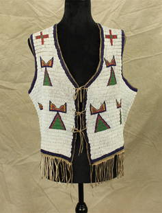
Sold2022Plains Indian Beaded VestOutstanding 1890's men's beaded vest with tremendous full coverage beadwork, having pleasing geometric pattern and uncommon bottom finger. Size approximately 38.See Sold Price
Sold2022Pre-colonial Gold Mask from Butuan/Surigao, 10th – 14th CenturiesPre-colonial Gold Maskfrom Butuan/Surigao, 10th – 14th Centuries 22k gold mounted on to 420 grams of Sterling Silver Chainmailwith Sterling Silver Frame, solid Balayong Base 22 1/2" x 7 1/2" xSee Sold Price
Sold2021A COLONIAL MAP, "Carte de la Louisiane et du Cours duA COLONIAL MAP, "Carte de la Louisiane et du Cours du Mississipi," PARIS, JUNE 1718, hand colored engraving on paper, "Dressée sur un grand nombre de Mémoires entr'autres sur ceux de Mr. le Maire paSee Sold Price
Sold2021Sydney Lawrence, oil on canvas on boardSydney Lawrence, oil on canvas on board, Sydney Mortimer Lawrence (American, 1865-1940), Western Mountain Landscape, signed lower right, 9"h x 13.5"w (sight), 14.5"h x 18.5"w (frame) Provenance: A PriSee Sold Price
Sold2023Western NC Mountain Landscape with Wagon and Figures, Hudson River School StyleAmerican School, Western North Carolina, mid 19th century oil on canvas landscape painting from the Asheville, NC region depicting a view of mountains in the background and a rocky cliffside to the leSee Sold Price
Sold2019Rare GEORGE JONES Majolica Centerpiece "Africa"Very Rare Majolica GEORGE JONES Centerpiece/Compote from the Continents Series, "Africa". It shows a Lion and Lioness under a tree with a Lizard hiding under a burrow. c. 1874 this is one of the fourSee Sold Price
Sold20221772 Boston Almanac With PAUL REVERE Engravings!Colonial America 1772 Paul Revere Engraved Metal Cut Illustration Prints Including the Historic Portrait of Patriot John Dickinson (PAUL REVERE, JR.) 1772-Dated Colonial Pre-Revolutionary War Period,See Sold Price
Sold2019WorldTitle/Content of Map: World Date: 1493 Cartographer: Schedel Material/Medium: Woodblock engraving Size: 18x25” The oldest decorative world map that’s obtainable. Map shows 12 wind heads, shows theSee Sold Price
4 days LeftKensington Estate Auction19th C. Albumen Photographs, British Colonial India (116)US$150(1 bid)
May 29Cedarburg Auction & Appraisals LLCSet of Four Maps Showing All of Spain and PortugalUS$150(2 bids)
4 days LeftKensington Estate AuctionDE KREKO BROS, TRAVELING CARNIVAL SHOWS -WILD WEST POSTER, CHICAGO 1920sUS$100
Jun 29JM Hobby Supply and Railroad Artifact AuctionsDelaware Lackawanna and Western RR Sessions Station ClockUS$400
May 29Cedarburg Auction & Appraisals LLCRare 1877 Double sided map of Milwaukee and WisconsinUS$35(3 bids)
Jun 02Schilb Antiquarian Rare Books1863 Emancipation of SLAVERY in America CIVIL WAR French Colonies Cochin RAREUS$1