Sold20211899 Utah MapAuthor: Cram Title: 1899 Utah Map Medium: Ink on Paper Dimensions: 14"X21.5" Map of Utah dated 1899. Printed and published by George Cram in Chicago. Part of his Family Atlas. Double folio map. Key upSee Sold Price
Sold2022Large Cram's 1930 Double Sided Railway Map in Industrial Frame, Washington & UtahLarge Cram's 1930 Double Sided Railway Map in Industrial Frame, Washington & Utah. Fantastic educational maps on hard board showing railways and census information are marked The George Cram Co, IndiaSee Sold Price
Sold2021Impressive & scarce map of N. Calif/Nevada, 1882Two-page map of Northern California, Nevada Territory and western portion of Utah from the extremely scarce 1882 Cram’s Unrivaled Family Atlas of the World. The only Cram atlas maps that were haSee Sold Price
Sold2017VINTAGE MAPS AND MOREVINTAGE MAPS - UTAH OIL REFINING COMPANY - WESTERN STATES - SHELL - MAP OF NEVADA/UTAH AND ARIZONA/NEW MEXICO - RPM MOTOR OIL MAP - CALIFORNIA POINTS OF INTEREST AND TOURING MAP - AND MANY MORE - ALLSee Sold Price
Sold20211855 Gunnison Map of Colorado and Utah -- Map No. 4Title: 1855 Gunnison Map of Colorado and Utah -- Map No. 4 From the Coo-Che-To-Pass to the Wahsatch Mountains Under the direction of the Hon. Jefferson Davis… Cartographer: J Gunnison Year / Place:See Sold Price
Sold20221855 Beckwith Map of Northern Utah -- Map No. 1 FromTitle: 1855 Beckwith Map of Northern Utah -- Map No. 1 From the Valley of Green River to the Great Salt Lake from Explorations and Surveys Made Under the Direction of Hon. Jefferson Davis, Sec. of WarSee Sold Price
Sold2021ASSORTED CIGARETTE SILKS, LOT OF 151 +/-ASSORTED CIGARETTE SILKS, LOT OF 151 +/-, comprising 101 flags, 32 botanical, six medals, four animals, four actresses, two state seals, Utah map, and Princeton pennant, some marked for Chesterfield,See Sold Price
Sold20181894 Cram Antique Map of Nashville verso MemphisTitle/Content of Map: 1894 Cram Map of Nashville verso Memphis -- Nashville (verso) Memphis Date Printed: 1894, Chicago Cartographer: G Cram Size: 12.8 X 10.1 A nice highly detailed map of Nashville aSee Sold Price
Sold20201938 R Taylor White Pictorial Map of Utah -- UtahTitle/Content of Map: 1938 R Taylor White Pictorial Map of Utah -- Utah Date: 1938, Boston Cartographer: Ruth Taylor White Size: 11.6 x 8.5 in. This is Ruth Taylor White's charming pictorial map, or cSee Sold Price
Sold2023Scarce RR map of Utah from Gray’s National AtlasGray’s New Map of Utah by Frank A. Gray. From a scarce 1884 edition of Gray’s National Atlas. Shows Indian reservations, deserts, railroads, topography. Clean with a 1.5” tear at topSee Sold Price
Sold20231877 Mitchell Map of Utah and Nevada [verso] Arizona and New Mexico -- County Map of of Utah andTitle: 1877 Mitchell Map of Utah and Nevada [verso] Arizona and New Mexico -- County Map of of Utah and Nevada [verso] County Map Arizona and New Mexico Cartographer: S Mitchell Year / Place: 1877 PhiSee Sold Price
Sold20191876 Mitchell Map of Utah and Nevada [verso] ArizonaTitle/Content of Map: 1876 Mitchell Map of Utah and Nevada [verso] Arizona and New Mexico -- County Map of of Utah and Nevada [verso] County Map Arizona and New Mexico Date: 1876 Philadelphia CartograSee Sold Price
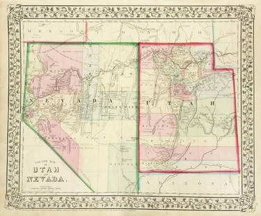
Sold20231881 Map of Utah & Nevada by Mitchell1881 Map of Utah & Nevada by Mitchell. Overall size 22 1/2"h x 29 1/2"wSee Sold Price
Sold20231938 R Taylor White Pictorial Map of Utah -- UtahTitle: 1938 R Taylor White Pictorial Map of Utah -- Utah Cartographer: Ruth Taylor White Year / Place: 1938, Boston Map Dimension (in.): 11.6 x 8.5 in. This is Ruth Taylor White's charming pictorial mSee Sold Price
Sold2018Gray's New Map of Utah [verso] Arizona and New MexicoTitle/Content of Map: Gray's New Map of Utah [verso] Arizona and New Mexico Date: 1886, Philadelphia Cartographer: F Gray Size: 11.5 x 15 in. This is a very nice map of Utah and on the reverse New MexSee Sold Price
Sold20201892 Cowles Civil War Map of Utah, Nevada and Most ofTitle: 1892 Cowles Civil War Map of Utah, Nevada and Most of California plus March Route of the Army of Tennessee -- Territory and Military Department of Utah…1860 [and] March Routes of Army of TennSee Sold Price
Sold2017Mitchell: Antique County Map of Utah & Nevada, 1870[Utah, Nevada]. N. p: S. Augustus Mitchell, 1870s. The map was drawn and engraved by W. H. Gamble of Philadelphia. Coloured map. Approximately 11-3/4 x 14-/4 inches image area, one sheet, matted. FineSee Sold Price
Sold2018Mitchell: Antique Map of Utah and Nevada,1870Title/Content of Map: 1870 Mitchell Map of Utah and Nevada -- County Map of Utah and Nevada Date Printed: 1870 Philadelphia Cartographer: S Mitchell Size: 10.6 X 13.5 in. Handsome county map of Utah aSee Sold Price
Sold20201898 Rand McNally Map of Utah [verso] Wyoming -- UtahTitle: 1898 Rand McNally Map of Utah [verso] Wyoming -- Utah [verso] Wyoming Date: 1898 Chicago Cartographer: Rand McNally Size: 12.2 X 9.3 in. Additional Information: This is very nice map of Utah anSee Sold Price
Sold20201898 Rand McNally Map of Utah [verso] Wyoming -- UtahTitle/Content of Map: 1898 Rand McNally Map of Utah [verso] Wyoming -- Utah [verso] Wyoming Cartographer: Rand McNally Year/Place: 1898 Chicago Size: 12.2 X 9.3 in. This is very nice map of Utah and WSee Sold Price
Sold2016Map of Utah, 1895Title: Map of Utah Original engraving from "Atlas of the World" by Rand McNally Date: 1895 Dimensions: 14 x 21 1/4 inches Description: Map includes counties, geographical landmarks, streets and populaSee Sold Price
Sold20201888 Map of UtahAuthor: Watson Title: 1888 Map of Utah Medium: Ink on Paper Dimensions: 11.5"X14.5" Map of Utah dated 1888. Engraved and published by Watson in Chicago. Part of the Standard Atlas of the World. Key upSee Sold Price
Sold2019Mitchell: County Map of Utah & NevadaMap Title: County Map of Utah and NevadaCartographer: S. A. Mitchell Place/Date: Philadelphia / 1870 Size: 14" x 11 5/8" Condition: full color; light overall age toning The beautifully detailed and coSee Sold Price
Sold2017McNally: Map of Utah, 1898Detached leaf from the Indexed Atlas of the World. Colored print, each county a different color, with lots of detail regarding mountains, rivers, etc. Written information and lists of Indian reservatiSee Sold Price
4 days LeftJasper521879 Powell Map of Utah -- Map of Utah Territory Representing the Extent of the Irrigable, TimberUS$120
5 days LeftThomaston Place Auction GalleriesCOLLECTION OF TRAVEL EPHEMERA, BROCHURES, BOOKLETS, MAPS 1900-1950US$100
Jun 23Schilb Antiquarian Rare Books1877 Geology Geography Surveys 1ed Nevada Wyoming Utah George Wheeler US West 2vUS$1
5 days LeftJasper52ASIA Japanese Formosa British India Siam Oman Abu Debi (Dhabi) STANFORD 1894 mapUS$60
5 days LeftJasper52Indo-China. Indochina. Siam Annam Burma Thailand Cambodia. STANFORD 1894 mapUS$130
5 days LeftJasper52Central Asia. Trans-Caspian Aral Sea Khiva Bokhara Sirdaria STANFORD 1894 mapUS$140
5 days LeftJasper52Dutch & British North Borneo Sarawak Kalimantan Palawan. STANFORD 1894 old mapUS$120
Jun 29JM Hobby Supply and Railroad Artifact AuctionsFlorence & Cripple Creek RR Public Timetable-September 1894US$400
Jun 06Freeman's | HindmanSTEVENSON, Robert Louis (1850-1894). Treasure Island. London, Paris & New York: Cassell & Company,US$1,500
Jun 06Freeman's | HindmanSTEVENSON, Robert Louis (1850-1894). Kidnapped: Being Memoirs of the Adventures of David Belfour inUS$250
2024Albion AuctionsLloyds's 1897 Lot of 8 Natural History Maps. Distribution of PrimatesSee Sold Price


![1877 Mitchell Map of Utah and Nevada [verso] Arizona and New Mexico -- County Map of of Utah and: Title: 1877 Mitchell Map of Utah and Nevada [verso] Arizona and New Mexico -- County Map of of Utah and Nevada [verso] County Map Arizona and New Mexico Cartographer: S Mitchell Year / Place: 1877 Phi](https://p1.liveauctioneers.com/5584/293457/155766077_1_x.jpg?height=310&quality=70&version=1687903812)
![1876 Mitchell Map of Utah and Nevada [verso] Arizona: Title/Content of Map: 1876 Mitchell Map of Utah and Nevada [verso] Arizona and New Mexico -- County Map of of Utah and Nevada [verso] County Map Arizona and New Mexico Date: 1876 Philadelphia Cartogra](https://p1.liveauctioneers.com/5584/137769/69881187_1_x.jpg?height=310&quality=70&version=1552435690)


![Gray's New Map of Utah [verso] Arizona and New Mexico: Title/Content of Map: Gray's New Map of Utah [verso] Arizona and New Mexico Date: 1886, Philadelphia Cartographer: F Gray Size: 11.5 x 15 in. This is a very nice map of Utah and on the reverse New Mex](https://p1.liveauctioneers.com/5584/132630/67371636_1_x.jpg?height=310&quality=70&version=1544582541)
![1892 Cowles Civil War Map of Utah, Nevada and Most of: Title: 1892 Cowles Civil War Map of Utah, Nevada and Most of California plus March Route of the Army of Tennessee -- Territory and Military Department of Utah…1860 [and] March Routes of Army of Tenn](https://p1.liveauctioneers.com/5584/162681/82155385_1_x.jpg?height=310&quality=70&version=1583273475)
![Mitchell: Antique County Map of Utah & Nevada, 1870: [Utah, Nevada]. N. p: S. Augustus Mitchell, 1870s. The map was drawn and engraved by W. H. Gamble of Philadelphia. Coloured map. Approximately 11-3/4 x 14-/4 inches image area, one sheet, matted. Fine](https://p1.liveauctioneers.com/5584/107399/55057774_1_x.jpg?height=310&quality=70&version=1501794677)

![1898 Rand McNally Map of Utah [verso] Wyoming -- Utah: Title: 1898 Rand McNally Map of Utah [verso] Wyoming -- Utah [verso] Wyoming Date: 1898 Chicago Cartographer: Rand McNally Size: 12.2 X 9.3 in. Additional Information: This is very nice map of Utah an](https://p1.liveauctioneers.com/5584/164887/83261194_1_x.jpg?height=310&quality=70&version=1585745963)
![1898 Rand McNally Map of Utah [verso] Wyoming -- Utah: Title/Content of Map: 1898 Rand McNally Map of Utah [verso] Wyoming -- Utah [verso] Wyoming Cartographer: Rand McNally Year/Place: 1898 Chicago Size: 12.2 X 9.3 in. This is very nice map of Utah and W](https://p1.liveauctioneers.com/5584/182355/91727155_1_x.jpg?height=310&quality=70&version=1603285541)