Sold2023Matthaus Seutter Map of North AmericaColored engraving map of eastern North America by Matthaus Seutter (1678-1757). Framed; framing partially obscures borders. Map covers Eastern and Central United States and Canada, Northern Mexico, anSee Sold Price
Sold2022Canada and Northern United States 1878 MapSize: 18 X 13 inches approx. Unframed. Printed 1878. Centerfold as issued.See Sold Price
Sold202220th C. Yupik / Inupiaq Wood Shamanic Mask w/ WolfNative American, Northern United States / Canada, Inupiaq or Yupik people, ca. mid-20th to 21st century CE. A remarkable shamanic dance mask with a wolf's head carved from wood with extending feathersSee Sold Price
Sold2023Early Winnebago / Ojibwe Beaded Leather PouchNative American / First Nations, Northern United States / Canada, Great Lakes Region & Midwest, Winnebago / Ojibwe, ca. early 20th century CE. A hide bag with beadwork across both sides, the front panSee Sold Price
Sold2022c. 1788 French Map of the Eastern United StatesHistoric Maps c. 1788 Map, "Les Etats Unis de L'Amerique Septentrionale, Partie Orientale" (Eastern Part of the Northern United States of America) by M. (Rigobert) Bonne c. 1788 Map titled, "Les EtatsSee Sold Price
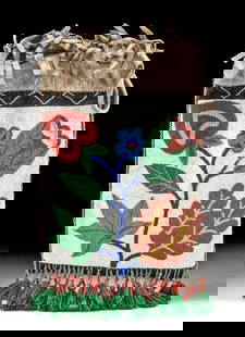
Sold202220th C. Alaskan Inuit Wool Felt Nivingajuliat Wall ArtNorth America, Northern United States / Canada, Inuit, Yupik or Aleut people, ca. mid-20th century CE. This is a charming embroidered felt textile wall hanging known as a nivingajuliat, with a stylistSee Sold Price
Sold202220th C. Alaskan Inuit Wool Felt Panel w/ Appliques**Originally Listed At $450** North America, Northern United States / Canada, Inuit, Yupik or Aleut people, ca. mid-20th century CE. A beautiful wool felt and embroidered textile wall hanging known asSee Sold Price
Sold2020"Northern provinces of the United States". THOMSON.TITLE/CONTENT OF MAP: 'Northern provinces of the United States' The map shows the "District of Maine", prior to its accession to the Union as the state of Maine in 1820. The top image on the right hanSee Sold Price
Sold2023Northern provinces of the United States. THOMSON. District of Main[e] 1817 mapTITLE/CONTENT OF MAP: 'Northern provinces of the United States' The map shows the "District of Maine", prior to its accession to the Union as the state of Maine in 1820. Some Native American Indian viSee Sold Price
Sold2019Northern provinces of the United States. THOMSON.TITLE/CONTENT OF MAP: 'Northern provinces of the United States' The map shows the "District of Maine", prior to its accession to the Union as the state of Maine in 1820. Some Native American Indian viSee Sold Price
Sold20162 United States Maps, including 1817.2 United States Maps, including 1817. 1st item: Northern Provinces of the United States map by John Thomson from "Thomson's New General Atlas", engraved by Nathaniel Rodgers Hewitt, 1817. Colored mapSee Sold Price
Sold2016Antique Map United States Thomson's 1817Antique Map United States Thomson's 1817, authentic antique map, inscribed, "drawn & engraved for Thomson's new general atlas 1817", along with "Northern Provinces of the United States", hand coloredSee Sold Price
Sold2018Thomson: Antique Map Northeastern United States, 1817Northern Provinces of the United States The beautifully detailed and colored northern United States map from Thomson's New General Atlas, with a lovely inset view of "the Great Falls of Niagara.'" CarSee Sold Price
Sold2022Vintage Botany Books Flowers, TreesVintage Botany Books Flowers, Trees The books in this lot include (1) Whittlesey House Feild Guide Series: Trees of the Eastern United States and Canada by William M. Harlow Published by McGraw-Hill BSee Sold Price
Sold2022The Picturesque Tourist, 1844.The Picturesque Tourist A Guide through the Northern & Eastern States, and Canada. NY, Disturnell, 1844. In a custom slip case.See Sold Price
Sold2016Field Sports of the United States, 1848Heading: Author: Forester, Frank [Henry William Herbert] Title: Field Sports of the United States and the British Provinces of Canada Place Published: London Publisher:Richard Bentley Date PubliSee Sold Price
Sold20201780 - Antique map of Canadian Maritime Provinces. 1780Title/Content of Map: 1780 - Antique map of Canadian Maritime Provinces. 1780 Cartographer: Rigobert Bonne Date Printed: 1780 Description: Colonial Northeastern United States & Canada. Rigobert Bonne,See Sold Price
Sold2020Rasmusio and Gastaldi Map of Eastern Seaboard 160Giovanni Battista Rasmusio (1485-1557) and Giacomo Gastaldi (1500-1566), "La Nuova Francia," Venice, 1606. Woodcut map depicting the eastern seaboard of the United States and Canada from New York BaySee Sold Price
Sold20191,000 Slides New England Canada & UKAbout 1,050 loose slides in 2 separate large baggies. One bag has Massachusetts, Eastern Canada and the United Kingdom (total about 560). The 2nd plastic bag has other New England states and Alaska (aSee Sold Price
Sold2022(UNITED STATES - REPUBLIC OF TEXAS.) James Wyld. Map of the United States and the Provinces of Upper(UNITED STATES - REPUBLIC OF TEXAS.) James Wyld. Map of the United States and the Provinces of Upper & Lower Canada, New Brunswick, and Nova Scotia, Compiled from the Latest Surveys and Other AuthentiSee Sold Price
Sold2022GLIMPSE AT THE U.S. & THE NORTHERN STATES OF AMERICA W/ THE CANADAS, 1853A Glimpse at the United States and the Northern States of America, with The Canadas Comprising Their Rivers, Lakes, and Falls During the Autumn of 1852; Including Account of an Emigrant Ship. Author:See Sold Price
Sold2022HENRY HUDSON LOUIS POTTERY COPPER BUST136138 HENRY HUDSON LOUIS POTTERY COPPER BUST Copper bust of renowned 17th century explorer Henry Hudson, known for his explorations of Canada and parts of the north-eastern United States. Signed LouiSee Sold Price
Sold20211844 map of the U. S., Canada & MexicoGreat map of the United States showing Texas in a very large configuration, otherwise known as the “Stovepipe” shape, with its northern border going all the way into what would become the state ofSee Sold Price
Sold2020Early Map of America, Eastern United States, M. SeutterTitled "Novi Belgii in America Septentrionali" with very elaborate cartouche and with vignette view of New Amsterdam (New York). Exquisite color, well preserved, laid down. Size: 19 7/8" x 22 3/4" (siSee Sold Price
23 hrs LeftTrillium Antique Prints & Rare BooksWilson - Brant, Scoter Duck, Velvet Duck, Harlequin Duck, Dusky Duck, Marsh Tern, Sooty Tern. 72US$75
23 hrs LeftTrillium Antique Prints & Rare BooksWilson - Louisiana Heron, Hooping Crane, Long-billed Curlew, & Pied Oyster-catcher. 64US$75
23 hrs LeftTrillium Antique Prints & Rare BooksWilson - Pied Duck, Red-breasted Merganser, American Widgeon, Snow Goose, Blue Bill or Scaup Duck,US$75
23 hrs LeftTrillium Antique Prints & Rare BooksWilson - Long-tailed Duck, Summer Duck, Green-winged Teal, Canvas-back Duck, Red-headed Duck,US$75
May 25Trillium Antique Prints & Rare BooksWilson - Roseate Spoonbill, Avoset, Plover, & Sandpiper. 63US$75
May 25Trillium Antique Prints & Rare BooksWilson - Red-tailed Hawk, American Buzzard, & Ash-coloured Hawk. 52US$75
1 day LeftActivity AuctionsAntique 1787 French Maritime Hydrography Map Eastern Coast United States M BonneUS$150
Jun 07Freeman's | HindmanMICHAUX, François André and Thomas NUTTALL. The North American Sylva...1852-1853. LaterUS$1,000


![Northern provinces of the United States. THOMSON. District of Main[e] 1817 map: TITLE/CONTENT OF MAP: 'Northern provinces of the United States' The map shows the "District of Maine", prior to its accession to the Union as the state of Maine in 1820. Some Native American Indian vi](https://p1.liveauctioneers.com/5584/309982/165835410_1_x.jpg?height=310&quality=70&version=1700599538)


![Field Sports of the United States, 1848: Heading: Author: Forester, Frank [Henry William Herbert] Title: Field Sports of the United States and the British Provinces of Canada Place Published: London Publisher:Richard Bentley Date Publi](https://p1.liveauctioneers.com/642/93238/47583951_1_x.jpg?height=310&quality=70&version=1472923400)


