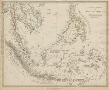
Sold2021MALAY ARCHIPELAGO/EAST INDIA ISLANDS PhilippinesTITLE/CONTENT OF MAP: 'Malay Archipelago or East India Islands' Vignettes: Victoria Mount - New Guinea; Near Sarawak - Borneo; Natives of New Guinea; The Bee Bear. The map covers the area from Burma aSee Sold Price
Sold2023WEST INDIA ISLANDS'. Caribbean Indies Antilles Bahamas. TALLIS/RAPKIN 1851 mapTitle: WEST INDIA ISLANDS'. Caribbean Indies Antilles Bahamas. TALLIS/RAPKIN 1851 map Description: West India Islands' by Map drawn and engraved by J. Rapkin; vignette illustrations drawn by H WarrenSee Sold Price
Sold2024East India islands & Indochina. Dutch E. Indies. Philippines. THOMSON 1817 mapTITLE/CONTENT OF MAP: East India Isles [and Birman Empire] A large map of the Dutch East Indies, Indochina and the Philippines. "Pinang" (Penang), "Bankok" (Bangkok), "Manilla" (Manila), and the StraiSee Sold Price
Sold2023POLYNESIA/PACIFIC ISLANDS. inc Sandwich/Hawaiian islands. RAPKIN/TALLIS 1851 mapCAPTION PRINTED BELOW PICTURE: 'Polynesia or Islands in the Pacific Ocean' Vignettes: Resolution Bay, Marquesas; Harbour of Dory, New Guinea; Otaheite [Tahiti]; Kalakakooa, Sandwich Islands [HawaiianSee Sold Price
Sold2023Lizars, Daniel 1831 LG Rare HC Map. East India Islands. Philippines Indonesia BorneoLarge Folio Copper Engraved Map Published 1831-2 by John Hamilton, Successor to Daniel Lizars, Edinburgh for "The Edinburgh Geographical and Historical Atlas..." First Edition by Daniel Lizars. Very fSee Sold Price
Sold2024West India Islands. West Indies Caribbean Jamaica Antilles. BARTHOLOMEW 1898 mapTITLE OF MAP (NOT PRINTED ON THE PAGE):'West India Islands' DATE PRINTED: 1898 IMAGE SIZE: Approx 29.5 x 40.5cm, 11.5 x 16 inches (Large) TYPE: Antique atlas map CONDITION: Good; suitable for framing.See Sold Price
Sold2020New Map of That Portion of North America 1851New Map of That Portion of North America Exhibiting the United States and Territories, the Canadas, New Brunswick, Nova Scotia and Mexico also Central America and the West India Islands, 1851, Jacob MSee Sold Price
Sold2023CABOOL PUNJAB & BELOOCHISTAN Pakistan Afghanistan Lahore. RAPKIN/TALLIS 1851 mapTITLE/CONTENT OF MAP: 'Cabool, The Punjab and Beloochistan' The map covers modern Pakistan, Afghanistan, and part of India. Vignettes: Boats on the Indus; Sultan Mahmoud's Minars and Fortress - GhuzneSee Sold Price
Sold2017Tallis: Map of the Caribbean & West India Islands, 18511851 Tallis Map of the Caribbean -- West India Islands. This is an ornate and highly decorative map of the Caribbean from the Bahamas to Columbia and Venezuela. The map features three vignettes and faSee Sold Price
Sold2022BRITISH MEDITERRANEAN POSSESSIONS. Gib Malta Corfu Zante. RAPKIN/TALLIS 1851 mapTITLE/CONTENT OF MAP: 'British Possessions in the Mediterranean' The map shows Gibraltar, Malta and Gozo, and the Ionian Islands including Corfu, Paxo, Zante, Cephalonia, Maura & Ithaca. The United StSee Sold Price
Sold2019WEST INDIA ISLANDS. Caribbean Indies Antilles Bahamas.TITLE/CONTENT OF MAP: 'West India Islands' Show the West Indies, Antilles, Windward Islands, Leeward Islands, Cuba, the Bahamas, Hispaniola, Turks & Caicos Islands. Vignettes: Kingston, Jamaica, fromSee Sold Price
Sold2021Tallis, John (Pub) 1852 Malay Archipelago. East IndiesSteel Engraved Map with Original Outline Hand Color Published 1852-56 by John Tallis, London for "The Universal Pronouncing Dictionary" by Thomas Wright. Drawn & Engraved by John Rapkin. Centre fold aSee Sold Price
Sold2024Ptolemy & Magini, pub. 1620 - Map of India and Surrounding Islands (East Indies)This early map engraving is from Claudius Ptolemaeus (Ptolemy) and Giovanni Antonio Magini's Geografia cio? Descrittione Universale della Terra Partita in due volumni, Nel Primo de' quali si contengonSee Sold Price
Sold2020Bartholomew, John 1922 Pair of Maps. East Indies"Farther India" and "Malay Archipelago" Large Lithograph Maps Published 1922 by The Times, London for "The Times Survey Atlas of the World" Maps by John George Bartholomew of the Edinburgh GeographicaSee Sold Price
Sold2019Isles Philippines, Célèbes & Moluques'. East Indies.TITLE/CONTENT OF MAP: 'Carte des Isle Philippines, Célèbes, & Moluques [Map of the Philippines, Sulawesi, and the Maluku Islands]' Philippines, Borneo, Sulawesi, Moluccas / Maluku & Lesser Sunda IslSee Sold Price
Sold2019WEST INDIES Antilles Caribbean Cuba Bahamas WindwardTITLE/CONTENT OF MAP: 'THE ANTILLES OR WEST INDIA ISLANDS' DATE PRINTED: 1874 IMAGE SIZE: Approx 32.5 x 42.0cm, 12.75 x 16.5 inches (Large) TYPE: Antique steel engraved map with original outline handSee Sold Price
Sold2024CARIBBEAN West Indies Central America Danish Virgin islands JOHNSTON 1901 mapTITLE/CONTENT OF MAP: 'West India Islands and Central America' DATE PRINTED: 1901 IMAGE SIZE: Approx 36.0 x 46.5cm, 14.25 x 18.25 inches (Large); Please note that this is a folding map. TYPE: AntiqueSee Sold Price
Sold2018Johnson: Antique Map of Australia & East Indies, 1867Title/Content of Map: Australia, islands of Indonesia, New Guinea & Philippines. Insert of New Zealand Date Printed: 1867 Cartographer: Johnson Material/Medium: Paper Size: 18" x 26 1/2" Please note tSee Sold Price
Sold2020MALAY ARCHIPELAGO Indonesia Malaysia PhilippinesTITLE/CONTENT OF MAP: 'EASTERN ISLANDS OR THE MALAY ARCHIPELAGO. Sumatra, Java, Borneo, etc' The top image on the right hand side shows the entire map. To view a close up of the map showing the levelSee Sold Price
Sold2020MALAY ARCHIPELAGO Indonesia Malaysia PhilippinesTITLE/CONTENT OF MAP: 'EASTERN ISLANDS OR THE MALAY ARCHIPELAGO. Sumatra, Java, Borneo, etc' The top image on the right hand side shows the entire map. To view a close up of the map showing the levelSee Sold Price
Sold2019Bartholomew, John 1922 Pair Large Maps of East Indies"Farther India" showing Siam, Indonesia, Singapore, Malaysia. Together with "Malay Archipelago" Large Lithograph Map Published 1922 by The Times, London for "The Times Survey Atlas of the World" MapsSee Sold Price
Sold2021Stanford (Pub) 1894 Lot of 9 Maps of Asia East IndiesIncl Celebes, Sumatra, Borneo, Java, Philippines, Stations of Government Officials in the East Indies, Volcanic System of Malaysia, Moluccas, and Sunda Islands. Lithograph Maps Published 1894 by EdwarSee Sold Price
Sold2017Weller: Antique Map of Borneo & Philippines, 1863Title/Content of Map: 'Borneo; The Philippine Islands' East Indies. Manila Zebu/Cebu. Date Printed: 1863 Image Size: Approx 32.0 x 43.5cm, 12.5 x 17.25 inches (Large) Type: Antique map with original oSee Sold Price
Sold2018Mercator/Hondius: Composite West Indies Islands MapCartographer: Mercator / Hondius Place/Date: Amsterdam / 1628/1630 Size: 20" x 14 1/4" Condition: wash color; cleaned and stabilized; minor spotting and tiny repaired wormhole in the sea in the PuertoSee Sold Price
6 days LeftJasper52CABOOL PUNJAB & BELOOCHISTAN. Pakistan Afghanistan Kabul. RAPKIN/TALLIS 1851 mapUS$150
2 days LeftTrillium Antique Prints & Rare BooksPrevost - Pair of Engravings of Indian Coast and OceanUS$50
Featured6 days LeftJasper52FRENCH INDOCHINA & DUTCH EAST INDIES Siam Burma Penang Manila Singapore 1912 mapUS$20
6 days LeftJasper52EAST ASIA INDUSTRIES. China Korea East Indies Philippines. Manila plan 1920 mapUS$50
6 days LeftJasper52Eastern Islands, Birmah &c. Indochina & East Indies. Indonesia. HALL 1856 mapUS$120
6 days LeftJasper52WORLD WAR 2 Japanese occupied Philippines Malaya Indochina Thailand 1942 mapUS$55(1 bid)
6 days LeftJasper52SOUTH ASIA. India Ceylon Sri Lanka Indochina Maldives. 'Inde'. MALLET 1683 mapUS$60
Jun 07Freeman's | HindmanBELLIN, Jacques-Nicolas. Carte Reduite de L'Ocean Oriental ou Mer Des Indies. Paris, 1757. SecondUS$150
6 days LeftJasper52Les Indes Orientales… South Asia India Indochina. SANTINI / VAUGONDY 1784 mapUS$85
2 days LeftTrillium Antique Prints & Rare BooksPrevost - Map of China, Korea, Japan, Phlippines and Surrounding IslandsUS$50
Featured6 days LeftJasper52Suite de l’Ocean Oriental…' East Asia/Indies. Western Pacific. BELLIN 1746 mapUS$200
4 days LeftBonhamsPrince Alexis Soltykoff (1806-59), Voyages dans L'Inde Paris, Garnier, [1851]£1,600
17 hrs LeftAlbion AuctionsGentleman's Magazine 1778 Map. Dominica West Indies Thomas BowenUS$5(1 bid)
2 days LeftTrillium Antique Prints & Rare BooksPrevost - Pair of Engravings of Chinese Boats or JunksUS$50
2 days LeftTrillium Antique Prints & Rare BooksPrevost - Chart of the Atlantic Ocean (Ocean Occidental, including parts of the Americas, Africa,US$50


![East India islands & Indochina. Dutch E. Indies. Philippines. THOMSON 1817 map: TITLE/CONTENT OF MAP: East India Isles [and Birman Empire] A large map of the Dutch East Indies, Indochina and the Philippines. "Pinang" (Penang), "Bankok" (Bangkok), "Manilla" (Manila), and the Strai](https://p1.liveauctioneers.com/5584/320546/172232433_1_x.jpg?height=310&quality=70&version=1709072904)
![POLYNESIA/PACIFIC ISLANDS. inc Sandwich/Hawaiian islands. RAPKIN/TALLIS 1851 map: CAPTION PRINTED BELOW PICTURE: 'Polynesia or Islands in the Pacific Ocean' Vignettes: Resolution Bay, Marquesas; Harbour of Dory, New Guinea; Otaheite [Tahiti]; Kalakakooa, Sandwich Islands [Hawaiian](https://p1.liveauctioneers.com/5584/298779/159029476_1_x.jpg?height=310&quality=70&version=1692132475)


![Isles Philippines, Célèbes & Moluques'. East Indies.: TITLE/CONTENT OF MAP: 'Carte des Isle Philippines, Célèbes, & Moluques [Map of the Philippines, Sulawesi, and the Maluku Islands]' Philippines, Borneo, Sulawesi, Moluccas / Maluku & Lesser Sunda Isl](https://p1.liveauctioneers.com/5584/139429/70692793_1_x.jpg?height=310&quality=70&version=1554845662)


![Prince Alexis Soltykoff (1806-59), Voyages dans L'Inde Paris, Garnier, [1851] (1 of 1)](https://p1.liveauctioneers.com/1043/328953/177308726_5_x.jpg?height=282&quality=70&version=1715163690)


