Sold2016MAP OF NEW ENGLAND'Nova Belgica et Anglia Nova', by Willem Blaeu (1571-1663), hand-colored engraving, after a manuscript map by Adriaen Block, see Burden 241: 'First printed map that depicts canoes and North American fSee Sold Price
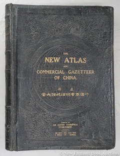
Sold2023Dingle, Edwin John51. Dingle, Edwin John. The New Atlas and Commercial Gazetteer of China. 28 color-printed maps and 18 color-printed statistical tables. Large folio, publisher's black cloth decorated in gilt and blindSee Sold Price
Sold2020Boston.4 folding lithograph maps, as listed below.Boston.4 folding lithograph maps, as listed below. First 2 folding into original 8vo printed wrappers (first detached); last with tears along several folds, generally clean and sound. Boston, vdBird'sSee Sold Price
Sold2022FIRST WORLD WAR. England Aeroplane Barrage line, December 1916 1931 old mapTITLE/CONTENT OF MAP: 'Aeroplane Barrage line, December, 1966' DATE PRINTED: 1931 IMAGE SIZE: Approx 39.0 x 26.5cm, 15.25 x 10.25 inches (Large) TYPE: Vintage colour map CONDITION: Good; suitable forSee Sold Price
Sold20241865 HISTORY of INDIAN WARS in NEW ENGLAND 2 volumes ILLUSTRATED w/ MAP antiqueThe History of The Indian Wars in New England from the First Settlement to the Termination of the War with King Philip, in 1677. by William HUBBARD (1621?-1704) Roxbury, Mass.: printed for W. Elliot WSee Sold Price
Sold2020China 1888Title/Content of Map: China 1888 Date Printed: 1888 Material/Medium: paper Size: 14.5x 11.5 inches Additional Info: John C. Lonngren & Son Standard Atlas of the World Reserve: $25.00 Shipping: DomestiSee Sold Price
Sold2023[MAP]. FRY & JEFFERSON. A Map of the Most Inhabited Part of Virginia. 1775. FIRST PRINTED MAP OF[MAPS & ATLASES]. FRY, Joshua (1699-1754) and Peter JEFFERSON (1708-1757). A Map of the Most Inhabited Part of Virginia containing the whole Province of Maryland with Part of Pensilvania, New JersSee Sold Price
Sold2018Norwich (England). First map of the cityReserve Reduced! Title/Content of Map: Norwich (England). First map of the city Date: 1572-1617 Size: 20x15 1/2” from Civitates Orbis Terrarum by Braun & Hogenberg, Cologne. Hand colored Reserve: $4See Sold Price
Sold2022ANTIQUE PRINTED MAP 'CHINA' BY J. & C. WALKER, London 1843 - 1844. Attractive hand-colour. ThisANTIQUE PRINTED MAP 'CHINA' BY J. & C. WALKER, London 1843 - 1844. Attractive hand-colour. This interesting and detailed map of China was published in the atlas volume published as 'Maps of The SoSee Sold Price
Sold2022AN ANTIQUE PRINTED MAP 'CHINA' BY J. WYLD / J. THOMSON, London 1825. Copperplate Original colour. AnAN ANTIQUE PRINTED MAP 'CHINA' BY J. WYLD / J. THOMSON, London 1825. Copperplate Original colour. An attractive nineteenth-century map of China with a vignette view of a Chinese village at lower rightSee Sold Price
Sold2022(10) Adams China Red Barn First Edition Service PlatesA group of 10 Adams China England First Edition 'Red Barn' series dinner plates after the works of Dale Nichols (American, 1904 - 1995) featuring a different red barn corresponding to each month of thSee Sold Price
Sold2023Blaeu map of Henan, China 1655Title/Content of Map: Blaeu map of Henan, China 1655 Date Printed: 1655 Cartographer: Johannes Blaeu Material/Medium: Paper. Copper engraving Size: 59.2cm x 50cm Provenance: Bought from long time AsiaSee Sold Price
Sold2023Blaeu map of Shanxi, China, 1655Title/Content of Map: Blaeu map of Shanxi, China, 1655 Date Printed: 1655 Cartographer: Johannes Blaeu Material/Medium: Paper. Copper engraving Size: 60.8cm x 50.7cm Provenance: Bought from long timeSee Sold Price
Sold2023Woodblock map of China, c18th centuryTitle/Content of Map: Woodblock map of China, c18th century Date Printed: c1700's Cartographer: Unknown Material/Medium: paper Size: 32.4cm x 28.5cm Provenance: Bought from long time Asian map collectSee Sold Price
Sold2018Johnson: Antique Map of China, 1863Title/Content of Map: 1863 Johnson Map of China -- Johnson's China Date Printed: 1863, New York Cartographer: A Johnson Size: 12.5 x 15.5 in. A very nice and highly detailed map of China. The provinceSee Sold Price
Sold2017Allen: Antique Title Page, View of China, 1843Title/Content of Map: Title page China views Date Printed: 1843-1865 Cartographer: J.B. Allen Material/Medium: Paper Size: 8" x 10 1/2" Published in London. Hand colored lithograph. Please note that tSee Sold Price
Sold2017Heine: Antique View of Canton China Fish Market, 1854Title/Content of Map: Canton China Fish Market Date Printed: 1854-1860 Cartographer: Wilhelm Heine Material/Medium: Paper Size: 11 1/2" x 8 1/2" canton, Guangzhou China. Publsihed in New York. Hand coSee Sold Price
Sold2022Bristol.- New History, Survey and Description of the City and Suburbs of Bristol (The), firstBristol.- New History, Survey and Description of the City and Suburbs of Bristol (The), first edition, folding engraved map, Bristol, Printed, Published and Sold by W. Matthews, 1794; bound with MatthSee Sold Price
Sold2017Arrowsmith: Antique Map of China and Korea, 1823Title/Content of Map: 1823 Arrowsmith Map of China and Korea -- China Date Printed: 1823, London / Edinburgh Cartographer: A Arrowsmith Size: 10 x 8 in. A striking Arrowsmith map, with wonderful colorSee Sold Price
Sold2022Middle East.- Escape map on silk.- War OfficeNO RESERVE Middle East.- Escape map on silk.- War Office (Geographical Section) Cairo; Alexandria - Torbuch, "restricted" military intelligence escape map, first edition, lithograph printed in coloursSee Sold Price
Sold2020China Indo-China Malaysia 1896Title/Content of Map: China Indo-China Malaysia 1896 Date Printed: 1896 Material/Medium: Paper Size: Approx. 14x21 inches Rand McNally & Co. Universal Atlas of the World Reserve: $30.00 Shipping: DomSee Sold Price
Sold2018Bartholomew: Antique Map of England & Wales, 1890Title/Content of Map: England & Wales Date Printed: 1890 Cartographer: BARTHOLOMEW, JOHN & CO. Size (inches): 11.25X11.6 "By J. Bartholomew, F.R.G.S." Polar projection. 11 Shows nautical routes. FromSee Sold Price
Sold2017Allen: Antique View China Pagoda Ships on Island, 1843Title/Content of Map: China Pagoda Ships on island Date Printed: 1843-1865 Cartographer: J.B. Allen Material/Medium: Paper Size: 8" x 10 1/2" Published in London. Hand colored lithograph. Please noteSee Sold Price
Sold2023Owen, Diana Princess of Wales, Book of Fashion, 1st/1st UK Ed. 1983, illustrated"Diana, Princess of Wales: The Book of Fashion" by Jane Owen, produced by Ted Smart and David Gibbon; published by Greenwich House, 1983, England, printed in Spain. First Printing of the First EditionSee Sold Price
May 16DuMouchellesGlobe of the World, Mahogany Frame, by Weber Costello Co., H 40" Dia. 23"US$225(2 bids)
6 days LeftJasper521581 BIBLE in LATIN PRINTED in ENGLAND antique 16th century BIBLIA LATINA RAREUS$1,200
May 16Oriental Art AuctionsBLUE AND WHITE: CHINESE PORCELAIN AROUND THE WORLD BY JOHNS CARSWELL, PRINTED IN SPAIN 2005€80
7 days LeftJasper52Carte des Royaumes de Belgique & Hollande. Belgium Netherlands. LAPIE 1833 mapUS$35
7 days LeftJasper52Carte de la Scandinavie… Scandinavia Sweden Norway Denmark. LAPIE 1830 old mapUS$45
7 days LeftJasper52Carte de l'Europe… l'invasion des barbares. Barbarian invasions. LAPIE 1830 mapUS$50
Featured6 days LeftJasper52Mitchell’s Map of Asia showing travel routes London, India, China & Japan, 1860US$45
7 days LeftJasper52SCANDINAVIA.Shows early railways inc Oslo-Eidsvoll.Norway Sweden.LOWRY 1863 mapUS$25
May 21BonhamsJ. Hutchison and J. Ph. Vogel, A History of the Panjab Hill States, 2 vols. Lahore, printed by ...£1,200
7 days LeftJasper52Home Waters. Blockade of Germany. Minefields. 1914. First World War. 1920 mapUS$20
7 days LeftJasper52Pursuit of SMS Goeben & Breslau. 3-5th August 1914. First World War. 1920 mapUS$25


![[MAP]. FRY & JEFFERSON. A Map of the Most Inhabited Part of Virginia. 1775. FIRST PRINTED MAP OF: [MAPS & ATLASES]. FRY, Joshua (1699-1754) and Peter JEFFERSON (1708-1757). A Map of the Most Inhabited Part of Virginia containing the whole Province of Maryland with Part of Pensilvania, New Jers](https://p1.liveauctioneers.com/197/305583/163286504_1_x.jpg?height=310&quality=70&version=1697143109)


