Sold2023Antique Harbour Plan - Map of Bay of Toulon - France, Marseille - MediterraneanTitle: Antique Harbour Plan - Map of Bay of Toulon - France, Marseille - Mediterranean Date/Period: 1804 Dimension: 7” x 9” inches / 17 cm x 23 cm Material: Paper Additional Information: OriginalSee Sold Price
Sold2020Burled Wood Framed Plan Map Stamford, Ct.Burled Wood Framed Plan Map Stamford, Ct. Professionally framed. 27 inches x 32 inches.See Sold Price
Sold2024Antique Hand-colored Harbour Plan - Map Milazzo - Sicily, Italy, MediterraneanOriginal hand-colored copper engraving print originates from "Recueil des Principaux Plans des Ports et Rades de la Mer Méditerranée …", translated from French as "CollectionSee Sold Price
Sold2018SDUK (Pub) 1830's Town Plan Map of Parma, Italy"Parma" Steel Engraved Map Published 1830's, London for "Maps by the Society for the Diffusion of Useful Knowledge" Paper Size: 16.5 x 13.5 inch (42 x 34cm) Good ConditionSee Sold Price
Sold2022KENT – LYDD – MANUSCRIPT ESTATE MAP 'A Map of a Farm lying in the Parish of Lydd in ...KENT – MANUSCRIPT ESTATE PLAN 'A Map of a Farm lying in the Parish of Lydd in the County of Kent Belonging to the Reverd. Mr Richard Monins 1774.', manuscript map by Henry Maxted & Isaac Terry,See Sold Price
Sold2022Map, A Plan of the Action at Bunkers Hill 1775Framed hand-colored engraved Revolutionary War battle plan map entitled: "A Plan of the Action at Bunkers Hill on the 17th of June 1775. Between His Majesty 's Troops, Under the Command of Major GenerSee Sold Price
Sold2022Walt Disney World Mickey’s Starland Prototype Lamppost Sign...Walt Disney World Mickey’s Starland Prototype Lamppost Sign. Circa 1990s. Prototype acrylic sign with mirrored elements depicting a smiling Mickey Mouse dressed in a tuxedo. 8 ¾ x 8”.See Sold Price
Sold2023The Black Pigeon - A Murder MysteryThe Black Pigeon A Murder Mystery - Floor plan map. Rare in this fine condition Author: Anne Austin Dated: 1929 Publisher: Grosset & DSee Sold Price
Sold20181844 Plans/Maps of the Ohio River at Louisville --Reserve Reduced! Title/Content of Map: 1844 Plans/Maps of the Ohio River at Louisville -- Report of the Secretary of War… A copy of the report of Captain T. J. Cram, on the best mode of improving thSee Sold Price
Sold20191831 McNeill Map of the Very Early New England RailroadTitle/Content of Map: 1831 McNeill Map of the Very Early New England Railroad Plans -- Map Exhibiting the Several Routes Surveyed for a Proposed Rail Road from Boston to Providence and also to TauntonSee Sold Price
Sold2023WWII German Invasion of England 2nd Ed. MapsWorld War 2 german military plan maps of london, england invasion. 2nd edition, 1941. Includes 5 maps and folder. All maps are in tact, some yellowing and minor wear to fold creases due to age.See Sold Price
Sold2023BOSWELL, Henry:BOSWELL, Henry: BOSWELL, Henry: Historical descriptions of new and elegant picturesque views of the antiquities of England and Wales. A Hogg, no date (1786). With 125 leaves of plates, plans & maps. FSee Sold Price
Sold20231823 ATLAS of UNITED STATES on IMPROVED PLAN 11 MAPS by MORSE antique AMERICANAATLAS of UNITED STATES on IMPROVED PLAN ; Consisting of TEN Maps, with Complete Index to Each and a General Map of the Whole Country by Sidney E Morse. New-Haven, engraved and published by N.& S.S. JoSee Sold Price
Sold2017Harrison: Antique Map Plan of London, 1776Title/Content of Map: 'A new and complete plan of London, Westminster and Southwark, with the additional buildings to the year 1777' Date Printed: 1776 Image Size: Approx 29.5 x 51.0cm, 11.5 x 20 inchSee Sold Price
Sold2017Munster: Antique Map Plan of Cusco, 1550Map: Die Statt Cusco Cartographer: Sebastian Munster Place & Date: Basle / 1550 Size: 14 3/4" x 10 5/8" Condition: B&W; overall age toning; some browning along centerfold and outer edges of margins; aSee Sold Price
Sold2023L'Africa. DE ROSSI / SANSON 1677 old antique vintage map plan chartTITLE/CONTENT OF MAP: L'Africa [Africa] DATE PRINTED: 1677 IMAGE SIZE: Approx 42.5 x 57.0cm, 16.75 x 22.25 inches (Large) TYPE: Antique 17th century folio atlas map CONDITION: Good; suitable for framiSee Sold Price
Sold2020PARIS antique town city map plan. Building profiles.TITLE/CONTENT OF MAP: 'PARIS' DATE PRINTED: This map was originally published by Baldwin & Cradock in 1834; this date is printed on the map. This edition of the map was printed and published by ChapmaSee Sold Price
Sold2024L'Irlanda o'vero Hibernia. Ireland. DE ROSSI 1689 old antique map plan chartTITLE/CONTENT OF MAP: L'Irlanda o'vero Hibernia [Ireland, or Hibernia] DATE PRINTED: 1689 IMAGE SIZE: Approx 59.0 x 45.0cm, 23.25 x 17.75 inches (Large) TYPE: Antique 17th century folio atlas map CONDSee Sold Price
Sold2019MOSCOW MOSKAU antique town city map plan & panorama.TITLE/CONTENT OF MAP: 'MOSCOW' DATE PRINTED: This map was originally published by Baldwin & Cradock in 1836; this date is printed on the map. This edition of the map was printed and published by ChapmSee Sold Price
Sold2020British Pine Plan Chest / Map File CabinetBritish Pine Plan Chest / Map File Cabinet - 26 in tall x 48 x 38See Sold Price
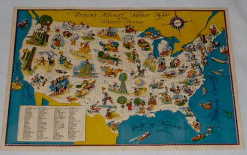
Sold2022Walt Disney Dixon's Mickey Mouse Map of United StatesEarly Disneyana collectible map. Copyright Walt Disney Enterprises 1935. Rare early pictorial map of the United States , richly illustrated with Disney character vignettes in each of the 48 states, MiSee Sold Price
Sold2019PHILADELPHIA antique town city map plan. Inset US Bank,TITLE/CONTENT OF MAP: 'PHILADELPHIA' The top image on the right hand side shows the entire map. To view a close up of the map showing the level of printed detail, please click on the bottom image on tSee Sold Price
Sold2024L'Europa. Europe. DE ROSSI 1677 old antique vintage map plan chartTITLE/CONTENT OF MAP: L'Europa [Europe] DATE PRINTED: 1677 IMAGE SIZE: Approx 44.0 x 56.5cm, 17.25 x 22.25 inches (Large) TYPE: Antique 17th century folio atlas map CONDITION: Good; suitable for framiSee Sold Price
Sold2017Tallis / Rapkin: Antique Map, Plan of Brighton, 1850Title/Content of Map: 'Brighton' Decorative antique town plan Date Printed: c1850 Image Size: Approx 36.5 x 26.5cm, 14.5 x 10.25 inches (Large) Type: Antique engraved map Condition: Good; suitable forSee Sold Price
5 days LeftJasper52Bombardment of Yarmouth & Lowestoft. 25th April, 1916. Tactical plan 1923 mapUS$35
5 days LeftJasper52Carte d'Assemblage de l'Europe. VANDERMAELEN 1827 old antique map plan chart TITLE/CONTENT OF MAP:US$40
4 days LeftJasper521861 Mitchell Map of Washington DC -- Plan of the City of Washington The Capitol of the UnitedUS$70
4 days LeftJasper52Bellin Map of St. Salvador, Brazil -- Plan de la ville de St. Salvador [with] Vue de la Ville de St.US$55
4 days LeftJasper521804 TRAVELS of Ledyard & Lucas in Africa antique w/ MAPS Voyages de MM. LédyardUS$240
May 30Forum AuctionsJudaica.- Israeli Defense Force (Educational Department) [Plan of The Temple Mount, or Haram£400
May 17Albion AuctionsGentleman's Magazine 1778 Canal Map. Belfast to Loughneagh Northern IrelandUS$5(1 bid)


![L'Africa. DE ROSSI / SANSON 1677 old antique vintage map plan chart: TITLE/CONTENT OF MAP: L'Africa [Africa] DATE PRINTED: 1677 IMAGE SIZE: Approx 42.5 x 57.0cm, 16.75 x 22.25 inches (Large) TYPE: Antique 17th century folio atlas map CONDITION: Good; suitable for frami](https://p1.liveauctioneers.com/5584/308981/165185503_1_x.jpg?height=310&quality=70&version=1699996168)

![L'Irlanda o'vero Hibernia. Ireland. DE ROSSI 1689 old antique map plan chart: TITLE/CONTENT OF MAP: L'Irlanda o'vero Hibernia [Ireland, or Hibernia] DATE PRINTED: 1689 IMAGE SIZE: Approx 59.0 x 45.0cm, 23.25 x 17.75 inches (Large) TYPE: Antique 17th century folio atlas map COND](https://p1.liveauctioneers.com/5584/326140/175577116_1_x.jpg?height=310&quality=70&version=1713288521)


![L'Europa. Europe. DE ROSSI 1677 old antique vintage map plan chart: TITLE/CONTENT OF MAP: L'Europa [Europe] DATE PRINTED: 1677 IMAGE SIZE: Approx 44.0 x 56.5cm, 17.25 x 22.25 inches (Large) TYPE: Antique 17th century folio atlas map CONDITION: Good; suitable for frami](https://p1.liveauctioneers.com/5584/322790/173578184_1_x.jpg?height=310&quality=70&version=1710881198)


![[COLOR PLATE BOOK]. MUDFORD, William (1782-1848). An Histor... (1 of 5)](https://p1.liveauctioneers.com/928/328184/176813588_1_x.jpg?height=282&quality=70&version=1714496988)
![Bellin Map of St. Salvador, Brazil -- Plan de la ville de St. Salvador [with] Vue de la Ville de St. (1 of 1)](https://p1.liveauctioneers.com/5584/328338/176911634_1_x.jpg?height=282&quality=70&version=1715113718)


