Sold2023FRAMED CIRCA 1750 HANDCOLORED MAP OF ITALY: L'ITALIE, VAUGONDY DIDIER ROBERT, Circa 1750. - FramedFRAMED CIRCA 1750 HANDCOLORED MAP OF ITALY: L'ITALIE, VAUGONDY DIDIER ROBERT, Circa 1750. Handcolored, of the period, Vaugondy Didier Robert map of Italy. Framed in wooden moulding with green mat. SigSee Sold Price
Sold20191792 Elwe Map of Italy -- LTitle: 1792 Elwe Map of Italy -- L'Italie Dressee sur les Observations de Mrs. de l'Academie Royale des SciencesÂ… Date: 1792, Amsterdam Medium: J Elwe Size: 18.2 X 21.6 in. Additional Information:See Sold Price
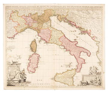
Sold2022Nicolas Sansom, map of Italy, 1701Nicolas Sansom, map of Italy, 1701, "L'Italie Divisee Suivant l'Estendue de Toutes ses Sourverainetes…", Pieter Schenk, Amsterdam, 1701, hand-colored copper plate engraving on laid paper, 20.25"See Sold Price
Sold2021Nicolas Sansom, map of Italy, 1701Nicolas Sansom, map of Italy, 1701, "L'Italie Divisee Suivant l'Estendue de Toutes ses Sourverainetes…", Pieter Schenk, Amsterdam, 1701, hand-colored copper plate engraving on laid paper, 20.25"See Sold Price
Sold2018Bonne: Antique Map of Italy, 1780TITLE/CONTENT OF MAP: 'L'Italie' A map of Italy DATE PRINTED: 1780 IMAGE SIZE: Approx 34.0 x 23.0cm, 13.25 x 9 inches (Large); Please note that this is a folding map. TYPE: Antique copperplate engraveSee Sold Price
Sold2023Baedeker, Karl 1901 Lot of 38 Antique Maps. ItalyLithograph Maps Published 1901, Leipzig for "L'Italie des Alpes a Naples" by Karl Baedeker. Folds as issued. Paper Size: Up to 13 x 12 inch (33 x 31cm) Good ConditionSee Sold Price
Sold2019Sanson map of Italy 1701Heading: Author: Sanson, Nicolas Title: L'Italie Divisee Suivant l'Estendue de Toutes ses Sourverainetes... Place Published: Amsterdam Publisher:Pieter Schenk Date Published: 1701 DescSee Sold Price
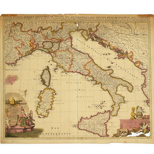
Sold2024Janvier Map of Italy - Italian Peninsula - Corsica, Sardinia"L'Italie divisee en ses differents etats Royaumes et Republiques" A beautiful example of Le Sieur Janvier's decorative map of Italy. Janvier's map covers from the Gulf of eyon eastward to include allSee Sold Price
Sold20201720 Chatelain Map of Italy -- Nouvelle Carte De L'EtatTitle: 1720 Chatelain Map of Italy -- Nouvelle Carte De L'Etat Present De L'Italie Pur Parvenir par Une Methode Nouvelle A La Connoissance De La Geographie Et De L'Histoire. . . Cartographer: H ChatelSee Sold Price
Sold20191838 Map of Italy and SicilyCarte de L'Italie Ancienne and de L'Illyrie et de La Sicilie par Delamanche 1838See Sold Price
Sold2018Brue: Antique Map of Northern Italy & the Alps, 1875TITLE/CONTENT OF MAP: 'Carte Physique et Politique de l'Italie de la Region des Alpes et des Provinces Autrichiennes sur l'Adriatique' A physical and political map of Northern Italy and the Alps incluSee Sold Price
Sold2023Baedeker, Karl 1886 Map. Venice Venezia. ItalyLithograph Map Published 1886, Leipzig for "L'Italie des Alpes a Naples" by Karl Baedeker. Folds as issued. Paper Size: 14.5 x 10 inch (37 x 25cm) Good Condition overallSee Sold Price
Sold2018Depot de la Marine 1881 Large Map of Sardinia & Italy"Carte du Bassin Compris Entre La Sardaigne, L'Italie et la Sicile d'apres les materiaux les plus recents" Steel Engraved Map Published 1881, Paris. Issued by the Depot de la Marine. Folded verticallySee Sold Price
Sold2018Depot de la Marine 1881 Large Map of Sardinia & Italy"Carte du Bassin Compris Entre La Sardaigne, L'Italie et la Sicile d'apres les materiaux les plus recents" Steel Engraved Map Published 1881, Paris. Issued by the Depot de la Marine. Folded verticallySee Sold Price
Sold2016Map of Italy. Europe. 1854.Print of hand colored steel engraving titled „Carte pour servir a l’histoire del’Italie“.Drawn by L. Dussieux.Engraved by unknown.From „Atlas General De Geographie physique, politique et hisSee Sold Price
Sold2018Mallet: Antique Map of Ancient North Italy, 1683Title of the Map: 'Partie Septentrionale de l'Ancienne Italie' ANCIENT ITALY NORTH. Gallia Cisalpina. Ancienne Italie Septent. Date Printed: 1683 Image Size: Approx Overall page size 13 x 21cm approxiSee Sold Price
Sold2018Mallet: Antique Map of Ancient Northern Italy, 1683Title of the Map: 'Partie Septentrionale de l'Ancienne Italie' ANCIENT ITALY NORTH. Gallia Cisalpina. Ancienne Italie Septent. Date Printed: 1683 Image Size: Approx Overall page size 13 x 21cm approxiSee Sold Price
Sold2017Mallet: Antique Map of Ancient Northern Italy, 1683Title of the Map: 'Partie Septentrionale de l'Ancienne Italie' ANCIENT ITALY NORTH. Gallia Cisalpina. Date Printed: 1683 Image Size: Approx Overall page size 13 x 21cm approximately (5 x 8 inches); imSee Sold Price
Sold2015Map of Ottoman Empire and Italy in 1400 - 1500.Map of Ottoman Empire and Italy in 1400 - 1500. Print in 1850.Print of steel engraving titled „L‘Empire Ottoman apres la prise de Constantinople L‘Italie a l‘epoque de l‘asservissement des VSee Sold Price
Sold2019ANCIENT ITALY SOUTH. Magna Graecia. Ancienne ItalieTITLE OF THE MAP: 'Partie Meridionale de l'Ancienne Italie' Includes the Adriatic & the Dalmatian Coast DATE PRINTED: 1683 IMAGE SIZE: Approx Overall page size 13 x 21cm approximately (5 x 8 inches);See Sold Price
Sold20221692 Peeters Map of the Americas -- AmericaeTitle: 1692 Peeters Map of the Americas -- Americae Cartographer: J Peeters Year / Place: 1692, Antwerp Map Dimension (in.): 5.9 X 7.3 in. This superb map of the Americas features California as an islSee Sold Price
Sold20231692 Peeters Map of the Philippines, Indonesia and Japan -- Les Isles Philippines Molucques et de LaTitle: 1692 Peeters Map of the Philippines, Indonesia and Japan -- Les Isles Philippines Molucques et de La Sonde [inset with] Les Isles du Iapon Cartographer: J Peeters Year / Place: 1692, Antwerp MaSee Sold Price
Sold20221692 Peeters Map of Asia -- AsiaeTitle: 1692 Peeters Map of Asia -- Asiae Cartographer: J Peeters Year / Place: 1692, Antwerp Map Dimension (in.): 5.9 X 7.2 in. This is a lovely map of Asia with interesting geographic inaccuracies. HSee Sold Price
7 days LeftJasper521719 Chatelain Map of the Adriatic and Venice Republic -- Carte de Geographie des Differents EtatsUS$190
Jun 08Early American History Auctions1776 Map, PARTIE ORIENTALE DU CANADA, AVEC LA NOUVELLE ANGLETERRE, L'ACADIE... by P. Santini, FramedUS$950
BonhamsFauteuil à haut dossier recouvert de tapisserie de Bruxelles. Italie, XVIIe siècle€260
3 days LeftTrillium Antique Prints & Rare BooksKohler - Timewheel with Volvule of the Kings and Dukes of Italy (Discus Chronologicus RegumUS$75
Jun 07Austin Auction Gallery(PAIR) ESTATE ROBERTO COIN 18KT GOLD & DIAMOND 'MAURESQUE' CIRCLE DROP EARRINGSUS$400(1 bid)
Jun 04TimeLine Auctions Ltd.Medieval Gilt Wooden Relief with Enthroned Virgin and Child Surrounded by Angels£550(3 bids)


![1692 Peeters Map of the Philippines, Indonesia and Japan -- Les Isles Philippines Molucques et de La: Title: 1692 Peeters Map of the Philippines, Indonesia and Japan -- Les Isles Philippines Molucques et de La Sonde [inset with] Les Isles du Iapon Cartographer: J Peeters Year / Place: 1692, Antwerp Ma](https://p1.liveauctioneers.com/5584/291247/154270240_1_x.jpg?height=310&quality=70&version=1686144622)


