Sold2024Burgess & Cain 1853 Map #9 Wisc and MichTitle: Burgess & Cain 1853 Map #9 Wisc and Mich Dimension: 11 ½” x 9 ½” Provenance:A beautiful colored map of what were the middle states in 1853. It shows all the major cities,See Sold Price
Sold2023Burgess & Cain 1853 Map #7 OH, IN, KY, TNTitle: Burgess & Cain 1853 Map #7 OH, IN, KY, TN Dimension: 11 ½” x 9 ½” Provenance:A beautiful colored map of what were the northern middle states in 1853. It shows all the majoSee Sold Price
Sold2017Burgess: Antique Map of the United States & Canada 1853Map of the United States and Canada, Burgess 1853. Great map of the U. S. during the transitional period of the American West. Most of the western lands are shown as large territories: Minnesota, NebrSee Sold Price
Sold2017Fascinating 1853 Map of Western StatesFascinating 1853 map of Western States. Daniel Burgess. Early, interesting configuration of the West prior to the inclusion of Colorado, Idaho, Wyoming, Montana, Nevada and Arizona. New Mexico TerritoSee Sold Price
Sold2018Eastman 1853 Map of New MexicoThe South Western Part of New Mexico . Compiled from the latest explorations and drawn by Capt. S. Eastman. 9 1/2"h. x 12 1/2"W.See Sold Price
2017Burgess: Antique Map of the United States, 18531853 Map of the United States with large Texas. Daniel Burgess. Delightful early school atlas map of the region. Shows counties, parishes, towns, rivers, populations, Indian Tribes, Court Houses, FortSee Sold Price
Sold2024Map of California, Utah, Oregon,New Mexico 1853Map of California, Utah, Oregon,New Mexico, Washington and Nebraska Hand colored. Map No 10 United States Cartographer: Jules Sherman Smith Publisher Daniel Burgess Dated: 1853<See Sold Price
Sold20211853 Havana, Cuba, Paseo del PradoTitle/Content of Map: 1853 Havana, Cuba, Paseo del Prado Date Printed: 1853, Boston Cartographer: Gleason's Pictorial Size: 9 1/2" x 7" (featured image); 10" x 14 1/2" (overall sheet). A splendid viewSee Sold Price
Sold20201853 U. S. map w/large Texas, Daniel BurgessDelightful early school atlas map of this region. Shows counties, parishes, towns, rivers, populations, Indian Tribes, Court Houses, Forts and many other details. Includes several steamships and notesSee Sold Price
Sold20191853 No. 4 United States, BurgessInteresting map of the Atlantic states from Mitchell’s 1853 School Atlas published by Thomas, Cowperthwait & Co. The map is copyrighted by Daniel Burgess. In this map West Virginia is still part ofSee Sold Price
Sold2017Smith: Map of Maine New Hampshire Vermont, 1853Title: Map No. 1 United States- Maine, New Hampshire, Vermont Date: 1853 Size: 9.5 x 11.5 inches From Smith's "Quarto Geography Atlas. Revised Edition, with New Census" Please note that this lot has aSee Sold Price
Sold2019Map of Africa Designed to Accompany Smith's GeographyTitle: Map of Africa Designed to Accompany Smith's Geography for Schools Publication Date: 1844 Cartographer: STILES, SHERMAN & SMITH, engr. Publisher: DANIEL BURGESS, Size: 9.25Height - 11.3Width DesSee Sold Price
Sold2021GEORGE BURGESS 1853 CALIFORNIA GOLD MINING OPERATIONMokelunme River watercolor 10 x 14 inches. signed and dated. framed. 16 x 20 inches (overall) * Note: During the California Gold Rush, the Mokelumne was a major gold-producing stream. The first personSee Sold Price
Sold2024Extremely rare, >> 1748, with 9 maps--- & 59 double-page engravingsExtremely rare,< large Dutch Bible>>> 1748, with 9 maps--- & 59 double-page engravingsSee Sold Price
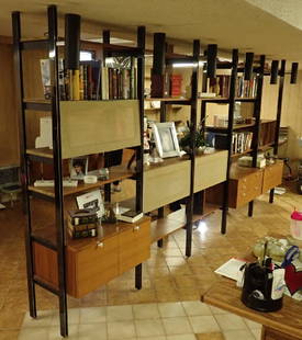
Sold2018Early Herman Miller 5-Bay CSS Omni Wall UnitFrom the Estate of Joyce Dankoff. Herman Miller 5-Bay CSS Omni Wall Unit. Mid-Century.Designed by George Nelson. Maker's mark reads: "Designed By George Nelson Herman Miller Zeeland Mich.". 9 drawersSee Sold Price
Sold2018Vincent Van Gogh (1853-1890) Pen & InkPen and brown ink on fine BFK Rives laid paper (full 19th century watermark), peasant women working in a field, signed (Vincent van Gogh*, 1853-1890). 9 1/4 x 12 1/4 inches. Good condition. Unframed fSee Sold Price
Sold2022San Mateo Co., Cal., Tide Lands at auction 1871Heading: (California - San Mateo County) Author: Allardt, Geo. F., Surveyor Title: Sale Map No. 9. Salt Marsh and Tide Lands situate in the County of San Mateo, State of California. To be sold at publSee Sold Price
Sold2021Vincent Van Gogh (1853-1890) Pen & Ink DrawingPen and dark brown ink drawing on wove sketchbook paper, landscape with sun, signed* (Vincent van Gogh, 1853-1890). 9 1/2 x 6 inches. Very good condition, having no tears or visible repairs. Sold unfrSee Sold Price
Sold2023Vincent Van Gogh* (1853-1890) Pen & Ink Drawing (See Disclaimer)Pen and ink drawing on wove paper, landscape with farm houses, signed (Vincent van Gogh*, 1853-1890). 9 x 12 1/2 inches. There are no readily apparent condition issues with this lot; no damage, no repSee Sold Price
Sold2020Vincent Van Gogh (1853-1890) Pen & Ink DrawingPen and ink drawing with traces of pencil on laid paper, cypress trees with starry sky, signed* (Vincent van Gogh, 1853-1890). 9 x 11 1/8 inches. Very good condition, having no readily apparent repairSee Sold Price
Sold2021Vincent Van Gogh (1853-1890) Pen & Ink DrawingPen and brown ink drawing on wove sketchbook paper, two trees with bushes in a landscape, signed* (Vincent van Gogh, 1853-1890). 9 1/2 x 6 inches. Very good condition, having no tears or visible repaiSee Sold Price
Sold2024Vincent Van Gogh* (1853-1890) Pen & Ink Drawing (See Disclaimer)Pen and ink drawing with traces of pencil on laid paper, landscape with trees and sun, signed (Vincent van Gogh*, 1853-1890). 9 x 6 3/4 inches. Very good condition overall; no readily apparent damageSee Sold Price
Sold2018VINCENT VAN GOGH Dutch 1853-1890 Tempera/GouacheTempera and gouache on paper. Featuring self-portrait. Attr. Vincent Van Gogh (Dutch, 1853-1890). 9.6 x 7.9 inches (24.5 x 20 cm). Primarily self-taught and unappreciated during his lifetime, VincentSee Sold Price
Sold2022Chinese Book of History 1877Chinese book of history, 1877. Eleven volumes. Reprinted Guangyu Ji (Qing Dynasty), updated by Cai Fangbing of Pingjiang. With a silk box. Includes lovely maps.Height: 9 3/4 in x width: 7 in x depth:See Sold Price
Jun 08Early American History Auctions1853 Specialized Map, Railroads in the United States in Operation and Progress... Treasury DeptmentUS$200(1 bid)
5 days LeftForum Auctionsd'Anville (Jean Baptiste Bourguignon) [Untitled Composite Atlas with 102 map sheets], [probably£2,000
Jul 07A-1 AuctionLot (6) Fighting Knives- 3 Cattaraugus 225 Q Knives; Rostfrei, Marbles & WWII Military KnifeUS$425(8 bids)
Jun 08Early American History Auctions1720 Colonial Northumberland County Virginia Manuscript Deed and Map PlotUS$400
5 days LeftJasper52South America. Commercial/Industrial Development. Agricultural products 1925 mapUS$8
Jun 08Early American History Auctionsc 1730 Hand-Colored Colonial Era Map of the Americas, California shown as an Island, Matted + FramedUS$500(1 bid)
Jun 23Treasure Quest AuctionsGreene County, NY Directory for 1896 by Fred Craigie, Catskill NY with MapUS$50
Jun 22Check the Oil Promotions, LLCTexaco Travel Service Advertising Map Rack Display with 50 MapsUS$25(1 bid)
5 days LeftForum AuctionsAmerica.- California gold mining.- Palmer (N.S.) Autograph Letter signed to his brother on mining£400
Featured6 hrs LeftCain Modern AuctionsVintage Water Pitcher by Los Castillo, Taxco Mexico 1960sUS$400(1 bid)
Featured6 hrs LeftCain Modern AuctionsFrancisco Zuniga 20 Drawings Portfolio by Galeria De Arte Misrachi-MexicoUS$4,000
6 hrs LeftCain Modern Auctions1960s Silver & Copper Figurative Sculpture Made in Taxco Mexico, Los CastilloUS$125(2 bids)
6 hrs LeftCain Modern AuctionsEmilia Castillo Figural Monkey Water Pitcher, Silver over Copper, 20TH Century MexicoUS$250(2 bids)
6 hrs LeftCain Modern AuctionsWhimsical Copper & Malachite Water Pitcher by Los Castillo, Mexico 1960sUS$400


![d'Anville (Jean Baptiste Bourguignon) [Untitled Composite Atlas with 102 map sheets], [probably (1 of 3)](https://p1.liveauctioneers.com/5458/329231/177514974_1_x.jpg?height=282&quality=70&version=1715269091)


