Sold2020Jan Jansson Hand Colored Old Map of South AmericaJan Jansson (Johannes Janssonius; Dutch, 1588-1664). Framed antique etching print of South America. Titled AMERICAE PARS MERIDIONALIS. Hand colored. Unknown printing date in two sheets joined in the mSee Sold Price
Sold2023South America (Relief). Rivers Mountains 1907 old antique map plan chartTitle: South America (Relief). Rivers Mountains 1907 old antique map plan chart Description: South America (Relief)' by Scientific American (1907). Vintage colour map, 21.0 x 17.5cm, 8.25 x 7 inches;See Sold Price
Sold2021MAP, Western Hemisphere, BlaeuBlaeu's Stunning Carte-a-Figures Map of the Americas in Full Contemporary Color. Western Hemisphere - America. Willem Blaeu, Americae Nova Tabula, 1642 (circa). Hand Color. This stunning carte-a-figurSee Sold Price
Sold2017America, Rare Early Map of the Americas"America", Rare Early Map of the Americas by Jodocus Hondius (Flemish/Dutch, 1563-1612) for a French edition of Mercator's Atlas, North and South America, hand-colored copper engraved map, published ASee Sold Price
Sold2022De Wit, Map of North and South America, c. 1720Property of a Private Collector, Hilton Head Island, SC Description: Frederick De Wit (circa 1629-1706), Nova Orbis Tabula In Lucem Edita, A.F. De Wit, Amsterdam: Covens and Mortier, c. 1720, publSee Sold Price
Sold2015Munster. TABULA NOVARUM INSULARUM... [c. 1558-59.][Munster, Sebastian] TABULA NOVARUM INSULARUM, QUAS DIVERSIS RESPECTIBUS OCCIDENTALES & INDIANAS UOCANT. Double-page woodcut map of North and South America by Sebastian Munster. First cut in 1540, thiSee Sold Price
Sold2022(AMERICAS.) Sebastian Münster. Die Neuwen Inseln. So Hinder Hispanien Gegeu Orient Bey Dem Land(AMERICAS.) Sebastian Münster. Die Neuwen Inseln. So Hinder Hispanien Gegeu Orient Bey Dem Land India Ligen. Hand-colored double-page woodcut map of North and South America. 12x15 inches sheet siSee Sold Price
Sold2017Valdivian Limestone Star Chart Relief - 4000 Years Old!Pre-Columbian, South America, Ecuador, Valdivian, Earliest Horizon, ca. 2300 to 2000 BCE. A hand carved, light grey limestone palette of a somewhat rectangular form with incised, string-cut diagonal aSee Sold Price
Sold2018ACUÑA, Cristóbal de (1597-1676?). Voyages andACUÑA, Cristóbal de (1597-1676?). Voyages and Discoveries in South-America. London: for S. Buckley, 1698. 8vo (190 x 111 mm). 2 folding engraved maps; 3 title-pages. (Pale spotting.) 19th-century taSee Sold Price
Sold2022Ortelius 16th Cent. ''Americae Siv Novi Orbis' MapAbraham Ortelius 16th Cent. ''Americae Siv Novi Orbis Nova Descriptio'' Map Engraving. Hand tinted Western Hemisphere map of America circa 1570-73, printed in Antwerp. Gallery framed with glass on botSee Sold Price
Sold2023Old Trinity by Guy Carleton WigginsGuy Carleton Wiggins (1883 - 1962) United States of America. Old Trinity, depicting 3 American flags. Oil on Canvas. 17.25 x 14.5 (framed), 11.5 x 8.5 (canvas). "Old Trinity at Wall Street, New York"See Sold Price
Sold2022Attr. to Norton Bush (USA/California, 1834-1894)Attributed to Norton Bush (American/California, 1834-1894) "On the Magdalena, South America" oil on canvas unsigned; pencil-titled and inscribed en verso. Framed. 17-3/4" x 26-1/2", framed 21-1/2" x 3See Sold Price
Sold20241777 Revolutionary War Map America Septentrionalis1777 hand-colored map published by Homann Heirs, Nuremberg, showing the British colonies in North American, published in the midst of the American Revolution, entitled "America Septentrionalis a DominSee Sold Price
Sold2019A Long black robe with bead decorationLot #161 through #170 are the items used in old south "J.D. Morgan Tent Show", the show was ended around 1910 and these items are left from one of the performers of the show. The photo of the performeSee Sold Price
Sold20231810-Dated Original Beautifully Engraved, South Carolina Society, Membership CertificateColonial America "South Carolina Society" Beautifully Engraved Certificate July 10, 1810-Dated Federal Period, Partially-Printed, "South Carolina Society" Certificate (Plate likely produced c. 1757),See Sold Price
Sold20211721 Map of America With California as an IslandHistoric Maps 1721 Hand-Colored "A New Map of America from the Latest Observations" with "California" Shown as an Island 1721 Hand-Colored Engraved Western Hemisphere Map titled, "A New Map of AmericaSee Sold Price
Sold2024John Bowles (British 1709 - 1779)John Bowles (British 1709 - 1779) "A New and Exact Map of America Laid Down from the Latest Observations and Discoveries", circa 1750 Two sheet map engraving of the "Representation of the Customs andSee Sold Price
Sold20201761 MAP OF NORTH AMERICA BY ROCQUE18th century map GENERAL MAP OF NORTH AMERICA 1754-1761 by John Rocque, London by A. Drury, 2 part map, 35.5 x 36 inches, good condition.See Sold Price
Sold2016Map of North America...David H. Vance, engraved by J.H. Young. Philadelphia: Anthony Finley, 1825. Engraved map in 5 parts with original hand color in outline. 25 7/8 x 20 1/2 inches sheet, 30 5/8 x 25 1/2 inches framed.See Sold Price
Sold2021c 1730 Seutter Map: Novi Belgii, in America ...Historic Maps c. 1730 Historic Rare Earlier State of Seutter's Important American Northeast Map & New York City Restitutio View c. 1730 Hand-Colored Copper-Engraved Map titled, "Recens Edita totius NoSee Sold Price
Sold2017William Faden 1796 Map Eastern US, North AmericaFaden, William (BRITISH, 1749-1836); Map of the Eastern United States, North American with British Territories and Those of Spain according to the Treaty of 1784 (from a larger atlas), 1796; handcolorSee Sold Price
Sold2023AMERICAN SCHOOL (Circa 1900,), Portrait of the New York pilot boat 21, the William H. Aspinwall.,AMERICAN SCHOOLCirca 1900Portrait of the New York pilot boat 21, the William H. Aspinwall. Unsigned. Retains old label verso for the South Street Seaport Museum.Oil on canvas, 22î x 27.5î. FrameSee Sold Price
Sold2017Robert Morden - English Plantations in AmericaRobert Morden (d. 1703) and William Berry (fl. 1669-1708) makers A New Map of the English Plantations in America both Continent and Ilands Shewing their true Situation and distance from England or oneSee Sold Price
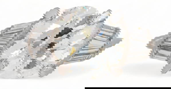
Sold20234.21 tcw Diamond Old European Cut Engagement Ring4.21 tcw diamond old european cut engagement ring, central prong set round old European cut diamond (3.01 ct, certified by the Gemological Institute of America, clarity VS-2, color K, certificate numbSee Sold Price
Jun 25Freeman's | Hindman[Maps & Atlases] Seutter, Matth(ias).: Novus Orbis sive America...US$300(1 bid)
5 days LeftTrillium Antique Prints & Rare BooksPrevost - Volume 16 with 31 Maps & Engravings (Including Map or Australia)US$210(2 bids)
5 days LeftTrillium Antique Prints & Rare BooksMunster, pub. 1614 - Diagram of Horizon, Parallels, et al.US$50
5 days LeftTrillium Antique Prints & Rare BooksMunster, pub. 1614 - View of Tours in Touraine, FranceUS$50
5 days LeftTrillium Antique Prints & Rare BooksMunster, pub. 1614 - View of Sion (Sitten), SwitzerlandUS$50
Jul 14Schilb Antiquarian Rare Books1881 Jules Verne 1st ed 800 Leagues Amazon Jangada South America French HetzelUS$52(2 bids)
Jun 30Heartland Artifact Auctions IncPre Columbian Pottery Head, South America, Ex Randall May CollectionUS$10
3 days LeftWalnut Tree Auction House, Inc.Jar with green glaze sprinkled with gold, floral mouthUS$200
Jun 28South Florida Auction & Estate Sale Services IncBlack Americana Cast Iron Aunt Jemima Working Cast Iron Mechanical BankUS$12(2 bids)
Jun 28South Florida Auction & Estate Sale Services Inc1896 Black Americana Cast Iron Mechanical Coin BankUS$260(5 bids)
Jun 28South Florida Auction & Estate Sale Services IncCast Iron Black Americana SMILING SAM Mechanical Coin BankUS$280(3 bids)
Jun 28South Florida Auction & Estate Sale Services IncBlack Americana Cast Iron JOLLY NEGRO Mechanical BankUS$270(2 bids)


![Munster. TABULA NOVARUM INSULARUM... [c. 1558-59.]: [Munster, Sebastian] TABULA NOVARUM INSULARUM, QUAS DIVERSIS RESPECTIBUS OCCIDENTALES & INDIANAS UOCANT. Double-page woodcut map of North and South America by Sebastian Munster. First cut in 1540, thi](https://p1.liveauctioneers.com/179/82189/42599755_1_x.jpg?height=310&quality=70&version=1447864785)


![[Maps & Atlases] Seutter, Matth(ias).: Novus Orbis sive America... (1 of 2)](https://p1.liveauctioneers.com/65/332523/179335174_1_x.jpg?height=282&quality=70&version=1717709447)


