Sold2021Tallis, John (Pub) 1852 Map. Cabool, The Punjab. IndiaSteel Engraved Map with Original Outline Hand Color Published 1852-56 by John Tallis, London for "The Universal Pronouncing Dictionary" by Thomas Wright. Drawn & Engraved by John Rapkin. Centre fold aSee Sold Price
Sold2023Russell & Barclay 1840 Hand Col Map. Hindoostan or IndiaHand Colored Copper Engraved Map Published 1823-40, by Fisher & Son, "A Complete Atlas of the World" by John Russell et al. A Very Rare Work which is compiled from the same plates used in different edSee Sold Price
Sold2022Nat. Encyclo. C1875 Lot of 5 Maps - AsiaIncl China, Turkey in Asia, Asia Continent, North and South India. Lithograph Map Published C1868-81 by William Mackenzie, London for "The National Encyclopedia: A dictionary of Universal Knowledge" CSee Sold Price
Sold2021Rollos & Vaugondy 1765 Map of The East Indies & India"The East Indies distinguishing the Empires and Kingdoms on the Continent commonly call'd India" Copper Engraved Map Published 1764-66, London for "A New History of England..." by Thomas Mortimer. MapSee Sold Price
Sold2022Tallis, John (Pub) C1860 Map of British India"British India" Steel Engraved Map Published C1860, London for "The Indian Empire: Its History, Topography, Government" by Robert Montogmery Martin. Centre fold as issued. Paper Size: 13.5 x 10.5 inchSee Sold Price
Sold2020Goldsmith, Oliver 1840 Mountain Chart"Comparative Heights of Mountains" Steel Engraved Map Published 1840 by Blackie and Sons, Glasgow & London for "A History of the Earth and Animated Nature" by Oliver Goldsmith. Engraved by W & D DuncaSee Sold Price
Sold2020Findlay, Alex 1840 Map of The MediterraneanSteel Engraved Map Published 1840 by Fisher & Son, London for "The Shores and Islands of the Mediterranean" By the Rev. George Newham Wright. Drawn and Engraved by Alexander Findlay. Paper Size: 16.5See Sold Price
Sold2019Europe 1840-73 Pair of Maps by Findlay & Lowry"The Mediterranean , and Turkish Empire" Steel Engraved Map Published 1840, London for "The Shores and Islands of the Mediterranean" By the Rev. George Newham Wright. Drawn & Engraved by Alexander FinSee Sold Price
Sold2020Rapkin, John 1860 Map of India"British India" Steel Engraved Map Published 1860 by The London Printing & Published Company, London for "The Royal Dictionary-Cyclopedia for Universal Reference" by Thomas Wright. Drawn & Engraved bySee Sold Price
Sold2019The Times 1895 Mixed Lot of 6 MapsIncl Australia and New Zealand, England and Wales (South and North) Africa North East, Africa North West, and India North. Lithograph Maps Published 1895, London for "The Times Atlas" Paper Size: 21 xSee Sold Price
Sold2023ANTIQUE EAST INDIA ISLANDS C 1840 MAPAntique East India Color Lithograph Map c. 1840 by a British Mapmaker. Purchased at Wattis Fine Art, Hong Kong. Professionally framed and matted. In frame measures 23.25"x22.25"x1.25" Weight 7 pds. PRSee Sold Price
Sold2024Civil War era railroad map of the Carolinas, Johnson & BrowningDescriptionEarly, scarce edition of the Johnson map of the Carolinas, published shortly after the outbreak of the war in 1861 by Johnson & Browning. The last edition of this map to show the Johnson &See Sold Price
Sold201810 Maps of India. 1831-1835.[Asia/India] 10 Maps of India published for the Society for the Diffusion of Useful Knowledge. Lon: Baldwin & Cradock, 1831-1835. The maps are numbered with the highest being the Index Map, numbered "See Sold Price
Sold2019Blackie & Weller 1882 Pair of Maps of IndiaIndia and India South Part. Lithograph Maps Published 1882 by Blackie & Son, London for "The Comprehensive Atlas & Geography of the World" by W. G. Blackie. Maps by Edward Weller. Centre fold as issueSee Sold Price
Sold2019BRITISH INDIA. 'The Punjab Cashmere &c.' Kasmir.TITLE/CONTENT OF MAP: 'India the Punjab Cashmere &c.)' DATE PRINTED: 1863 IMAGE SIZE: Approx 31.0 x 44.0cm, 12.25 x 17.5 inches (Large) TYPE: Antique map with original outline colour CONDITION: Good;See Sold Price
Sold2021Wilkes, John 1807 Hand Col Map. Modern India"Hindoostan or Modern India" Hand Colored Copper Engraved Map Published 1796-1828 London for "Encyclopaedia Londinensis, or universal dictionary of arts, sciences and literature" by John Wilkes et al.See Sold Price
Sold2020Atlas of 8 jigsaw maps circa 1840 with boxHeading: (Games and puzzles) Author: Fremin, A.R., Ambroise Tardieu Title: Atlas of eight jigsaw maps circa 1840 with box Place Published: Paris Publisher:Auguste Logerot Date Published: [c.1See Sold Price
Sold2020Map of Hyderabad in British Raj IndiaHeading: (India) Author: Sohrabji, Faridoon assisted by Yousuf-ud-din Title: Hyderabad Municipal Survey Map Place Published: [Kolkata, India] Publisher:Survey of India Offices Date Published:See Sold Price
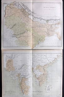
Sold2021Nolan, Edward C1880 Pair of Maps of India"India. The Bombay Presidency/India. The Madras Presidency" and "India The Bengal Presidency" Steel Engraved Map Published C1880, London for "The Illustrated History of the British Empire in India andSee Sold Price
Sold2020Bartholomew, John 1922 Pair of Maps. East Indies"Farther India" and "Malay Archipelago" Large Lithograph Maps Published 1922 by The Times, London for "The Times Survey Atlas of the World" Maps by John George Bartholomew of the Edinburgh GeographicaSee Sold Price
Sold2019United States of America exhibiting the [War of 1812]'.Reserve Reduced! TITLE/CONTENT OF MAP: 'United States of America Exhibiting the Seat of War on the Canadian Frontier from 1812 to 1815' A scarce map of the United States, published in 1816 shortly aftSee Sold Price
Sold2020Southern India.Title: Southern India. Description: 1744-1748 map by Emanuel Bowen, published by John Harris in Navigantium Atque Itinerantium Bibliotheca', or a Complete Collection of Voyages and Travels. London. AuSee Sold Price
Sold2020Ancient western India. Today’s Afghanistan & PakistanTitle: Ancient western India. Today’s Afghanistan & Pakistan Description: Map by Emanuel Bowen, published by John Harris in 'Navigantium Atque Itinerantium Bibliotheca' or a Complete Collection of VSee Sold Price
20181820. India by Lavoisne. Published by Carey and Son inMap: 1820. India by Lavoisne. Published by Carey and Son in Philadelphia. Size: 17 1/2” x 21 1/2” Please note that this lot has a confidential reserve. When you leave a bid in advance of the auctiSee Sold Price
3 days LeftJasper52Le Colonie Unite dell America Settentrale…. Bermuda. ZATTA 1779 old mapUS$800
5 days LeftTrillium Antique Prints & Rare BooksVan der Aa - Map of India: Hindustan (Explorer: Sir William Methold, first European to visit theUS$75
3 days LeftJasper52Chagos Archipelago Indian Ocean EAST INDIA COMPANY/Walker chart 1839 (1944) mapUS$300
3 days LeftJasper52Chagos Islands Peros Banhos Egmont Salomon EAST INDIA CO. chart 1839 (1940) mapUS$300
3 days LeftJasper52Maldive Islands #3 South Walker/EAST INDIA COMPANY sea chart 1839 (1950) mapUS$300
3 days LeftJasper52Maldive Islands #2 Centre Walker/EAST INDIA COMPANY sea chart 1839 (1950) mapUS$300
3 days LeftJasper52Maldive Islands #1 North Walker/EAST INDIA COMPANY sea chart 1839 (1950) mapUS$300
3 days LeftJasper52NEW YORK CITY antique town city map plan. Manhattan Brooklyn Jersey. SDUK 1844US$600
3 days LeftJasper52CONSTANTINOPLE ISTANBUL Antique city town map plan Stambool Galata SDUK 1844US$320
5 days LeftTrillium Antique Prints & Rare BooksAudubon - American Robin or Migratory Thrush. 142US$25


![10 Maps of India. 1831-1835.: [Asia/India] 10 Maps of India published for the Society for the Diffusion of Useful Knowledge. Lon: Baldwin & Cradock, 1831-1835. The maps are numbered with the highest being the Index Map, numbered "](https://p1.liveauctioneers.com/179/122672/62428323_1_x.jpg?height=310&quality=70&version=1527272450)


![Map of Hyderabad in British Raj India: Heading: (India) Author: Sohrabji, Faridoon assisted by Yousuf-ud-din Title: Hyderabad Municipal Survey Map Place Published: [Kolkata, India] Publisher:Survey of India Offices Date Published:](https://p1.liveauctioneers.com/642/178222/89706469_1_x.jpg?height=310&quality=70&version=1599147451)

![United States of America exhibiting the [War of 1812]'.: Reserve Reduced! TITLE/CONTENT OF MAP: 'United States of America Exhibiting the Seat of War on the Canadian Frontier from 1812 to 1815' A scarce map of the United States, published in 1816 shortly aft](https://p1.liveauctioneers.com/5584/134868/68484488_1_x.jpg?height=310&quality=70&version=1548203957)


