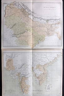
Sold2021Nolan, Edward C1880 Pair of Maps of India"India. The Bombay Presidency/India. The Madras Presidency" and "India The Bengal Presidency" Steel Engraved Map Published C1880, London for "The Illustrated History of the British Empire in India andSee Sold Price
Sold2019Japan C1880 Pair of Maps by Nolan & Blackie"The Islands of Japan with Corea..." Steel Engraved Map Published C1880, London for "The Illustrated History of the British Empire in India and the East" by Edward H. Nolan. Centre fold as published.See Sold Price
Sold2021Nolan, Edward C1880 Decorative Map of IndiaSteel Engraved Map Published C1880, London for "The Illustrated History of the British Empire in India and the East" by Edward H. Nolan. Centre fold as issued. Paper Size: 12 x 10 inch (30 x 25cm) GooSee Sold Price
Sold2021Nolan, Edward C1880 Map of The East India IslandsSteel Engraved Map Published C1880, London for "The Illustrated History of the British Empire in India and the East" by Edward H. Nolan. Centre fold as issued. Paper Size: 12 x 10 inch (30 x 25cm) GooSee Sold Price
Sold2019Nolan, Edward C1880 Map of The Eastern HemisphereSteel Engraved Map Published C1880, London for "The Illustrated History of the British Empire in India and the East" by Edward H. Nolan. Centre fold as published. Paper Size: 12.5 x 9.5 inch (32 x 24cSee Sold Price
Sold2021Nolan, Edward C1880 Map of Eastern HemisphereSteel Engraved Map Published C1880, London for "The Illustrated History of the British Empire in India and the East" by Edward H. Nolan. Centre fold as issued. Paper Size: 12 x 10 inch (30 x 25cm) SmaSee Sold Price
Sold2021Nolan, Edward C1880 Lot of 3 Maps. China, Japan, AsiaSteel Engraved Map Published C1880, London for "The Illustrated History of the British Empire in India and the East" by Edward H. Nolan. Centre fold as issued. Paper Size: 12 x 10 inch (30 x 25cm) GooSee Sold Price
Sold2023Nolan & Hughes C1880 Antique Map. Eastern HemisphereLithograph Map Published C1880, London for "The Illustrated History of the British Empire in India and the East" by Edward H. Nolan. Centre fold as issued. Drawn by W. Hughes. Paper Size: 12 x 10 inchSee Sold Price
Sold2022Reclus, Elisee C1880 Pair of Maps of IndiaLithograph Maps Published 1876-94, London for "The Universal Geography" by Elisee Reclus. Edited by A. H. Keane. Folds as issued. Paper Size: 14 x 10.5 inch (36 x 27cm) Approx. Good ConditionSee Sold Price
Sold2021Nolan, Edward C1880 Lot of 8 India Related PortraitsSteel Engraving Published C1880, London for "The Illustrated History of the British Empire in India and the East" by Edward H. Nolan. Paper Size: 10 x 7 inch (25 x 18cm) Good Condition overallSee Sold Price
Sold2021Nolan, Edward C1880 Lot of 8 India Related PortraitsSteel Engraving Published C1880, London for "The Illustrated History of the British Empire in India and the East" by Edward H. Nolan. Paper Size: 10 x 7 inch (25 x 18cm) Good Condition overallSee Sold Price
Sold2023Nolan, Edward C1880 Lot of 6 India Prints. Battles, ScenesSteel Engraving Published C1880, London for "The Illustrated History of the British Empire in India and the East" by Edward H. Nolan. Paper Size: 10 x 7 inch (25 x 18cm) A couple of minor faults. GoodSee Sold Price
Sold2023Nolan, Edward C1880 Lot of 6 India Related PortraitsSteel Engraving Published C1880, London for "The Illustrated History of the British Empire in India and the East" by Edward H. Nolan. Paper Size: 10 x 7 inch (25 x 18cm) Minor toning in parts, OtherwiSee Sold Price
Sold2023Nolan, Edward C1880 Lot of 6 India Related PortraitsSteel Engraving Published C1880, London for "The Illustrated History of the British Empire in India and the East" by Edward H. Nolan. Paper Size: 10 x 7 inch (25 x 18cm) Good Condition overallSee Sold Price
Sold2023Nolan, Edward C1880 Lot of 6 India Related PortraitsSteel Engraving Published C1880, London for "The Illustrated History of the British Empire in India and the East" by Edward H. Nolan. Paper Size: 10 x 7 inch (25 x 18cm) Good Condition overallSee Sold Price
Sold2019Nolan, Edward C1880 Lot of 6 Prints of IndiaSteel Engravings Published C1880, London for "The Illustrated History of the British Empire in India and the East" by Edward H. Nolan. Centre fold as published. Paper Size: 10 x 5 inch (25 x 16cm) VerSee Sold Price
Sold2023Nolan, Edward C1880 Lot of 4 Views of IndiaSteel Engraving Published C1880, London for "The Illustrated History of the British Empire in India and the East" by Edward H. Nolan. Paper Size: 10 x 7 inch (25 x 18cm) A couple of minor faults. GoodSee Sold Price
Sold2023Nolan, Edward C1880 Lot of 4 Views of IndiaSteel Engraving Published C1880, London for "The Illustrated History of the British Empire in India and the East" by Edward H. Nolan. Paper Size: 10 x 7 inch (25 x 18cm) A couple of minor faults. GoodSee Sold Price
Sold2023Nolan, Edward C1880 Lot of 9 Views & Scenes of IndiaSteel Engraving Published C1880, London for "The Illustrated History of the British Empire in India and the East" by Edward H. Nolan. Paper Size: 10 x 7 inch (25 x 18cm) Some toning in parts. Good ConSee Sold Price
Sold2019Blackie & Weller 1882 Pair of Maps of IndiaIndia and India South Part. Lithograph Maps Published 1882 by Blackie & Son, London for "The Comprehensive Atlas & Geography of the World" by W. G. Blackie. Maps by Edward Weller. Centre fold as issueSee Sold Price
Sold2021India C1880 Lot of 22 Views & Military Prints by NolanIncl Delhi. Steel Engraving Published C1880, London for "The Illustrated History of the British Empire in India and the East" by Edward H. Nolan. Paper Size: 10 x 7 inch (25 x 18cm) Minor toning in paSee Sold Price
Sold2021India C1880 Lot of 4 Views & Military Prints by NolanIncl Delhi. Steel Engraving Published C1880, London for "The Illustrated History of the British Empire in India and the East" by Edward H. Nolan. Paper Size: 10 x 7 inch (25 x 18cm) Good ConditionSee Sold Price
Sold2019India 1860-C1880 Lot of 6 Prints by Nolan & GardnerSteel Engravings Published C1880, London for "The Illustrated History of the British Empire in India and the East" by Edward H. Nolan and Steel Engraving Published 1858-60 by Fullarton & Co, London &See Sold Price
Sold2024Duval - Pair: Map of India & Map of MaldivesThis fascinating map is from Pierre Duval. It was part of a composite or collector's atlas of his maps. It was done in Paris circa 1670s. The composite atlas originally included maps from the followinSee Sold Price
4 days LeftTrillium Antique Prints & Rare BooksLinnaeus - Pair of Bird Engravings: Purple Indian Creeper & Green and Cinereous TodyUS$25(1 bid)
4 days LeftTrillium Antique Prints & Rare BooksPrevost - Pair of Engravings of Indian Coast and OceanUS$50
4 days LeftTrillium Antique Prints & Rare BooksForbes - Pair of Engravings of Fragrant Screw Pine (Pandanus odoratissimus) The Fruit of the KeuraUS$75
Jun 02Schilb Antiquarian Rare Books1897 History of British Empire England Scotland Canada James II MAPS India 6vUS$2(2 bids)
4 days LeftEstateOfMind Auctions4 PAIR AMERICAN INDIAN CHILDS BEADED DEERSKIN MOCCASINSUS$225(6 bids)
4 days LeftEstateOfMind AuctionsPR. AMERICAN INDIAN BEADED DEERSKIN WRIST CUFFS, 19TH CUS$110(3 bids)