Sold2015Map of California by Mitchell, 1883Original lithograph published by Augustus Mitchell, 1883. Map features inset of San Francisco Bay & Vicinity. Dimensions: 27" L x 19.75" WSee Sold Price
Sold2022County Map of California, Mitchell 1860Lovely hand-colored map of California during the Civil War era. One of the earliest maps of California to appear in an American Atlas. Shows California divided into counties, showing all major towns aSee Sold Price
Sold2019County Map of California, Mitchell 1860Lovely handcolored map of California during era of the Civil War. Published in the 1864 Mitchell General Atlas by S. Augustus Mitchell. Nice impression. Tiny water stain at lower left corner paper edgSee Sold Price
Sold2021Early 2-pg map of California w/Nevada, 1883Nice early double-page map of California from one of the earliest Cram atlases. Also shows most of Nevada. Shows only seven counties in southern part of the state below the 36th parallel (there are noSee Sold Price
Sold20211883 Map of CaliforniaAuthor: Cram Title: 1883 Map of California Medium: Ink on Paper Dimensions: 13.5"X22" Map of California dated 1883. Printed and published by George Cram in Chicago. Part of his World Atlas. Double folSee Sold Price
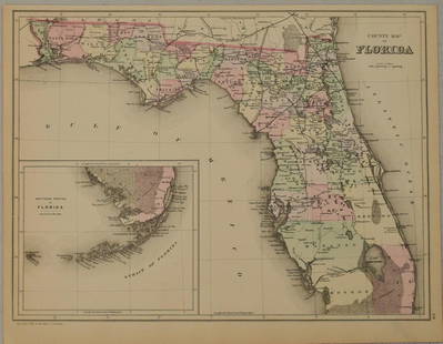
Sold20211883 Mitchell/Bradley Map of Florida -- County Map ofTitle: 1883 Mitchell/Bradley Map of Florida -- County Map of Florida Cartographer: Mitchell / Bradley Year / Place: 1883, Philadelphia Map Dimension (in.): 10.5 X 14.4 in. This is a rather handsome coSee Sold Price
Sold2017Map of California & Nevada Borax Fields 1883Heading: (California & Nevada) Author: Title: Map of California and Nevada showing the locality of the principal borax fields to accompany the third annual report of the State Mineralogist of CaliforSee Sold Price
Sold2017Mitchell: Map of California & Territories, 1854Map: Hand Colored Map Of California And The Territories Maker: Samuel Augustus Mitchell Date: 1854 Size: Approx. 6.5x8 inches Hand colored. From the 1854 Mitchell's School Atlas by Samuel Augustus MiSee Sold Price
Sold20191846 Mitchell Map of California and Oregon -- No. 15Reserve Reduced! Map Title/Content: 1846 Mitchell Map of California and Oregon -- No. 15 Map of Oregon and Upper California Cartographer: S Mitchell Year / Place: 1846, Philadelphia Map Dimension (in.See Sold Price
Sold20181869 Mitchell Map of CaliforniaTitle/Content of Map: 1869 Mitchell Map of California -- County Map of the State of California Date Printed: 1869, Philadelphia Cartographer: S. Mitchell Size: 21.2 x 14.6 in. An excellent large map oSee Sold Price
Sold20221876 Mitchell Map of California -- County Map of the State of CaliforniaTitle: 1876 Mitchell Map of California -- County Map of the State of California Cartographer: S. Mitchell Year/Place: 1876 Philadelphia Dimensions: 21.2 x 14.6 in. Description: An excellent large mapSee Sold Price
Sold20211874 Mitchell Map of California -- County Map of theTitle: 1874 Mitchell Map of California -- County Map of the State of California Cartographer: S. Mitchell Year / Place: 1874, Philadelphia Map Dimension (in.): 21.2 x 14.6 in. An excellent large map oSee Sold Price
Sold2022(AMERICAN WEST.) Samuel Augustus Mitchell. Oregon and Upper California.(AMERICAN WEST.) Samuel Augustus Mitchell. Oregon and Upper California. Engraved map of the vast regions of pre-territory Oregon and Upper California. 17x13¾ inches sheet size, wide margins withSee Sold Price
Sold2022RARE and Important Map of Upper California and Oregon territory. 1846 by MitchellTitle: RARE and Important Map of Upper California and Oregon territory. 1846 by Mitchell Date/Period: 1846 Dimension: 11 1/2 x9" Material: Hand colored engraved Additional Information: Rare only becauSee Sold Price
Sold20207 Maps incl North America and PanamaIncludes Panama to Guayaquil (Thomas Kitchin), Mexico & Gautemala (Thomas Coperthwait & Co., 1850), Utah & Nevada (Mitchell), California (Mitchell, 1874), State of Texas (Mitchell, 1852), North AmericSee Sold Price
Sold2023Mitchell's A New Map of Texas, Oregon and CaliforniaMitchell's A New Map of Texas, Oregon and California(Philadelphia: S. Augustus Mitchell, 1846), steel engraving with color, being a folding travel map laid to 20th century laminate for stability and pSee Sold Price
Sold2019Map of Oregon and Upper California...Reserve Reduced! Title: Map of Oregon and Upper California... Publication Date: 1846 Cartographer: MITCHELL, S.A. Publisher: MITCHELL, S.A. Size (inches): H10.5 - W8 From: Mitchell's School and FamilySee Sold Price
Sold2017Mitchell/Cowperthwait: Antique Map of the West US, 1850Title: Map of California, Oregon, Utah, and New Mexico by Mitchell and Cowperthwait Date: 1850 Medium: Lithograph Dimensions (in): 13.5 x 17 Condition: Good Condition with a little of foxing Samuel AuSee Sold Price
Sold2019Samuel Augustus Mitchell (1790-1868), " County Map ofSamuel Augustus Mitchell (1790-1868), " County Map of California with an inset of San Francisco and the Settlements of Great Salt Lake Country, Utah," 1867, hand colored, H.-15 1/8 in., W.-12 1/2 in.See Sold Price
Sold20171860 County Map of California1860 County Map of California Inset showing settlements in Great Salt Lake County. S. Augustus Mitchell, Jr. Engraved map with original hand-coloring by counties. Beautiful map of California with inseSee Sold Price
Sold20191886 California from Mitchell atlasFine antique lithograph map with original hand color. “County Map of the State of California” by William Bradley and found in the 1887 Mitchell New General Atlas. Detailed, scarce and interestingSee Sold Price
Sold2023Atlas: “Mitchell’s New General Atlas,” Augustus Mitchell, 1864Hand-colored lithographic maps, original boards disbound, lacks maps of Louisiana, California, Utah, Asia, Denmark, Switzerland and Hindoostan, remaining maps with bright colors Sold as a collection oSee Sold Price
Sold2023MITCHELL'S NEW MAP of TEXAS, OREGON & CALIFORNIA1846 Philadelphia, S. Augustus Mitchell. hardcover leather bound. 5 1/4 x 3 1/4 inches. Map unfolded 22 x 20 1/2 inches and presented in a custom frame 23 1/2 x 22 inches (overall)See Sold Price
Sold2022MITCHELL, S. AUGUSTUS. A New Map of Texas, Oregon and California.MITCHELL, S. AUGUSTUS. A New Map of Texas, Oregon and California. Engraved pocket map of the American territories west of the Mississippi River. 22¾x21 inches overall, ample margins; strong origiSee Sold Price
3 days LeftSimpson Galleries, LLC.J.H. Young (1792-1870) AN AMERICAN FEDERAL PERIOD MAP, "Mitchell's Travellers Guide Through theUS$500
Jun 23Schilb Antiquarian Rare Books1848 Emory Military Reconnaissance 1ed California MAP Indians Texas New MexicoUS$3(3 bids)
3 days LeftTrillium Antique Prints & Rare BooksSanson - Map of California as an Island, Mexico (Audience de Guadalajara)US$160(4 bids)
2 days LeftHolabird Western Americana CollectionsCalifornia Map by Colton in Frame, 1855 [180767]US$150(1 bid)
6 days LeftJasper521887 Mitchell Map of New Mexico and Arizona -- County and Township Map of Arizona and New MexicoUS$80
6 days LeftJasper521872 Mitchell Map of Massachussetts, Connecticut and Rhode Island -- County Map of Massachussetts,US$40
6 days LeftJasper521872 Mitchell Map of Louisiana, Arkansas and Mississippi -- County Map of the States of Arkansas,US$40
6 days LeftJasper521878 Mitchell Map of Georgia and Alabama -- County Map of the States of Georgia and AlabamaUS$50
Jun 13Swann Auction Galleries(NORTH AMERICA.) Group of 4 seventeenth-to-eighteenth-century engraved maps.US$500
Jun 27Rail & Road Auctions45 Peices of Western Railroad Paper Ephemera - Southern Pacific, Northern Pacific, Union Pacific,US$30(1 bid)
21 hrs LeftHolabird Western Americana CollectionsFont's Complete Diary / Founding of San Francisco 1933 [181866]US$75
21 hrs LeftHolabird Western Americana CollectionsBook Club of California Keepsakes, 3 Sets, 1933-58 [181196]US$200
21 hrs LeftHolabird Western Americana CollectionsMining Related Professional Papers U.S. Geological Survey Lindgren 1911; Knopf 1929 [183997]US$120
22 hrs LeftAkiba GalleriesAntique Mast, Crowell, & Kirkpatrick Map Of Texas, California, & NevadaUS$25(1 bid)
2 days LeftHolabird Western Americana CollectionsIndian Territory Map by Donaldson, 1883 [181628]US$100


![Arizona/New Mexico Map, 1883 [181626] (1 of 2)](https://p1.liveauctioneers.com/2699/331495/178785769_1_x.jpg?height=282&quality=70&version=1717355373)


![California Map by Colton in Frame, 1855 [180767] (1 of 3)](https://p1.liveauctioneers.com/2699/331495/178785753_1_x.jpg?height=282&quality=70&version=1717094933)
![Early California Map c1856 [179290] (1 of 1)](https://p1.liveauctioneers.com/2699/331495/178785754_1_x.jpg?height=282&quality=70&version=1717094933)


![Font's Complete Diary / Founding of San Francisco 1933 [181866] (1 of 8)](https://p1.liveauctioneers.com/2699/331494/178785432_1_x.jpg?height=282&quality=70&version=1717094654)
![Book Club of California Keepsakes, 3 Sets, 1933-58 [181196] (1 of 4)](https://p1.liveauctioneers.com/2699/331494/178785580_1_x.jpg?height=282&quality=70&version=1717094654)
![Mining Related Professional Papers U.S. Geological Survey Lindgren 1911; Knopf 1929 [183997] (1 of 11)](https://p1.liveauctioneers.com/2699/331494/178785586_1_x.jpg?height=282&quality=70&version=1717094654)

![Indian Territory Map by Donaldson, 1883 [181628] (1 of 1)](https://p1.liveauctioneers.com/2699/331495/178785757_1_x.jpg?height=282&quality=70&version=1717094933)