Sold20171860 County Map of California1860 County Map of California Inset showing settlements in Great Salt Lake County. S. Augustus Mitchell, Jr. Engraved map with original hand-coloring by counties. Beautiful map of California with inseSee Sold Price
Sold2022County Map of California, Mitchell 1860Lovely hand-colored map of California during the Civil War era. One of the earliest maps of California to appear in an American Atlas. Shows California divided into counties, showing all major towns aSee Sold Price
Sold2019County Map of California, Mitchell 1860Lovely handcolored map of California during era of the Civil War. Published in the 1864 Mitchell General Atlas by S. Augustus Mitchell. Nice impression. Tiny water stain at lower left corner paper edgSee Sold Price
Sold2019Eight (8) Augustus Mitchell MapsCollection of eight maps including New Jersey/Maryland Delaware 1872, Two north and South Carolina 1872 maps (15" x 12"), Minnesota 1890 , Florida and the Carolinas 1860, County map of the state of ArSee Sold Price
Sold20211860 York County MapFrom actual surveys by D.J. Lake. Published by W.O. Shearer & D.J. Lake. Includes business directory. Overall size 60" wide X 60" high. Canvas with losses and is brittle.See Sold Price
Sold2019Samuel Augustus Mitchell (1790-1868), " County Map ofSamuel Augustus Mitchell (1790-1868), " County Map of California with an inset of San Francisco and the Settlements of Great Salt Lake Country, Utah," 1867, hand colored, H.-15 1/8 in., W.-12 1/2 in.See Sold Price
Sold2022Prime example of 1860 California mapBeautiful map of California with excellent original hand coloring and in prime condition. Forts, towns, railroad lines, coastal features, travelers’ routes and geographical features are shown.See Sold Price
Sold2023An 1860 Map, Counties of New York, New Hampshire, Etc...Hand colored lithograph, by Samuel Augustus Mitchell (1790-1868). :County Map of the States of New York, New Hampshire, Vermont, Massachusetts, Rhode Island and Connecticut". Dimensions:15 1/2" x 23 1See Sold Price
Sold20221876 Mitchell Map of California -- County Map of the State of CaliforniaTitle: 1876 Mitchell Map of California -- County Map of the State of California Cartographer: S. Mitchell Year/Place: 1876 Philadelphia Dimensions: 21.2 x 14.6 in. Description: An excellent large mapSee Sold Price
Sold20211874 Mitchell Map of California -- County Map of theTitle: 1874 Mitchell Map of California -- County Map of the State of California Cartographer: S. Mitchell Year / Place: 1874, Philadelphia Map Dimension (in.): 21.2 x 14.6 in. An excellent large map oSee Sold Price
Sold20181869 Mitchell Map of CaliforniaTitle/Content of Map: 1869 Mitchell Map of California -- County Map of the State of California Date Printed: 1869, Philadelphia Cartographer: S. Mitchell Size: 21.2 x 14.6 in. An excellent large map oSee Sold Price
Sold2016George Cram: New Railroad of California & Nevada 1882Map: New Railroad and County Map of Northern California and Nevada Maker: George Franklin Cram Publishing: Chicago Date: 1882 Size: 11.5 x 19.3 inches Map with counties separately colored (15 in NV anSee Sold Price
Sold2015Pocket Map Stanislaus County, CaliforniaHeading: (California - Stanislaus County) Author: Weber, C.F. & Co. Title: Weber's map of Stanislaus County, California (cover title) Place Published: San Francisco Publisher:C.F. Weber & Co. DatSee Sold Price
Sold2019County Map of the State of CaliforniaReserve Reduced! Title: County Map of the State of California Publication Date: 1884 Cartographer: MITCHELL, S.A. Publisher: MITCHELL, S.A. Size (inches): H19.5 - W15 Map showing excellent topographicSee Sold Price
Sold2022County Map of The State of California 1881Rare antique map of the state of California showing counties, waterways, railroad routes and townships. "Entered according to Act of Congress in the year 1880 by S Augustus Mitchell in the office of tSee Sold Price
Sold20231860 Grafton County New Hampshire Topographic MapImmerse yourself in the rich history of Grafton County, New Hampshire, with this captivating Framed Topography Map from 1860. This vintage map offers a glimpse into the past, showcasing the intricateSee Sold Price
Sold2020Map of Pinecrest Lodge and LakeHeading: (California - Tuolumne County) Author: Title: Pinecrest Lodge, Pinecrest, Tuolumne County, California - General Map of Pinecrest... Place Published: Modesto, CA Publisher:Belt Printing & LitSee Sold Price
Sold20191886 California from Mitchell atlasFine antique lithograph map with original hand color. “County Map of the State of California” by William Bradley and found in the 1887 Mitchell New General Atlas. Detailed, scarce and interestingSee Sold Price
Sold2018Mitchell: Antique Map of Maine, 1860Title/Content of Map: 1860 Mitchell Map of Maine -- County Map of the State of Maine Date Printed: 1860, Philadelphia Cartographer: S Mitchell Size: 13.2 X 10.5 in. A very nice pastel color coded counSee Sold Price
Sold20181860 S. MITCHELL JR. NORTHEAST STATES COUNTY MAP1860 S. Augustus Mithcell Jr. County map of Pennsylvania, New Jersey, Maryland and Deleware. Map measures approx. 11 1/4" height x 13 3/4" width to sight..See Sold Price
Sold2019Samuel Augustus Mitchell (1790-1868), "County Map ofSamuel Augustus Mitchell (1790-1868), "County Map of the State of California, with an Inset of San Francisco Bvay and Vicinity," 1872, H.-23 1/4 in., W.- 15 1/4 in.See Sold Price
Sold2017LARGE SELCECTION OF RECREATIONAL & CITY MAPSLARGE SELCECTION OF RECREATIONAL & CITY MAPS - CALIFORNIA - MONTANA - TRINITY COUNTY - SHASTA LAKE - IDAHO & MANY MORESee Sold Price
Sold2023Rare 1st edition/1st state of County Map of Maine, Mitchell 1860From the exceptionally rare first printing of the 1860 New General Atlas by Samuel Augustus Mitchell Jr. This was Mitchell Jr’s first project after taking over his father’s business and heSee Sold Price
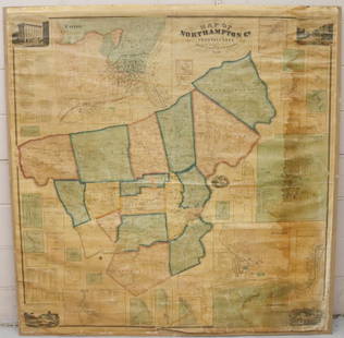
Sold2022MAP OF NORTHAMPTON COUNTY, PA 1860LINEN BACKED MAP MOUNTED ON BACKBOARD UNDER PLEXIGLASS (NO FRAMEWORK). SMITH,GALLUP & CO. PUBLISHERS, PHILADELPHIA, 1860. MEASURES 60" X 58". Terms & Conditions: Pick-up for this Auction will be WedneSee Sold Price
23 mins LeftJasper521860 Mitchell Map of Kentucky and Tennessee -- County Map of Kentucky and TennesseeUS$40
1 day LeftJasper52BLACK SEA Istanbul Odessa Sevastopol Sinop Varna views. TALLIS / RAPKIN 1860 mapUS$40
Featured1 day LeftJasper52TURKEY IN EUROPE. Constantinople/Istanbul view. Balkans. TALLIS/RAPKIN 1860 mapUS$20
1 day LeftJasper52BALTIC SEA Kronstadt St Petersburg Turku Tallinn Helsinki TALLIS/RAPKIN 1860 mapUS$50
1 day LeftJasper52Grecian Archipelago. Aegean Greek Islands Cyclades Dodecanese. HUGHES 1860 mapUS$60
5 days LeftOakridge Auction GalleryA Chinese red-ground embroidered 'butterfly' lady's robe, 19th centuryUS$200(2 bids)
3 days LeftOakridge Auction GalleryA Chinese famille rose boy-form incense holder, early 19th centuryUS$100
May 21Jasper521878 Mitchell Map of Virginia and West Virginia [verso] New Jersey, Maryland and Delaware -- CountyUS$45


![1878 Mitchell Map of Virginia and West Virginia [verso] New Jersey, Maryland and Delaware -- County (1 of 2)](https://p1.liveauctioneers.com/5584/329422/177662152_1_x.jpg?height=282&quality=70&version=1715717898)


