Sold2017Two 18th century engraved maps with hand coloringHind, Hindoostan, or India. Louis de la Rochette. Engraved map with hand color in part. London: W. Faden, c. 1790-1811. 31 x 23 inches framed. AND Africae in Tabula Geographica Delineatio. Adam FriedrSee Sold Price
Sold2023Brion Map of East AsiaLouis Brion de la Tour, French, 1743-1803. An 18th century engraved map with hand-coloring, titled "Chine, et Indes avec les Isles". Signed "par M. Brion" and dated "1766" in the plate lower left. MinSee Sold Price
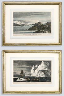
Sold20232 After Hodges Seascape EngravingsAfter William Hodges, British, 1744-1797. Two 18th century engraved seascapes on paper with hand-coloring from "A Voyage Towards the South Pole and Round the World..." by Captain James Cook. Titled "CSee Sold Price
Sold20222 E. Bowen Maps of Italy & GreeceEmanuel Bowen, Welsh, 1694-1767. Two 18th century hand-colored engraved maps. Includes one titled "Middle or Proper Italy" and another titled "A Map of Great Greece and the Islands of Sardinia and CorSee Sold Price
Sold20222 Antique Maps of Saltzberg & Swiss AlpsTwo 18th century hand-colored engraved maps. Includes one titled "Saltzberg" by Gabriel Bodenehr and another titled "La Descente du Cote du Midi des Alpes" (The Descent on the South Side of the Alps)See Sold Price
Sold20232 Malham's Naval Gazetteer MapsTwo early 19th century Malham's Naval Gazetteer engraved maps with hand-coloring. Includes "A Correct Chart of the West Indes" and "A Correct Chart of the Coasts of South America". Both dated "1801" uSee Sold Price
Sold202318TH C. M. SEUTTER NOVUS ORBIS SIVE AMERICA MAPCartographer Matthaus Seutter, German (1678-1757). Engraved map with hand-coloring. One of the last maps to feature California as an island. Dimensions: (Frame) H 22.5" x W 25.5" Condition: Not examinSee Sold Price
Sold2022SEVEN ENGRAVED MAPS.European, 18th-19th century. Printed with some hand coloring. Four on laid paper including three German and French military maps, "Plan des Camps de Pisek, 1741", 15.25"h. 20.25"w., battles of PeterwaSee Sold Price
Sold2020Group of French Maps Guillaume de l'Isle SansonGroup of four 17th and 18th century French maps. Guillaume Delisle (1675-1726) hand colored engraved map of Picardie, 1748. Two maps by Nicolas Sanson (1600-1677), "Le Roayaume de France" and "GouvernSee Sold Price
Sold2021"Terra FIrma and Caribbe Islands", Emanuel Bowen"A New and Accurate Map of the Terra Firma and the Caribbe Islands", an 18th century map by Emanuel Bowen (1693-1767). An engraved and hand colored map in two pages with central fold crease, framed. 1See Sold Price
Sold2018Engraved map of Canada and United StatesCarte de la Region Orientale des Etats-Unis et de la dominion du Canada, 19th century, engraved map with hand coloring, designed by A. Brue, overall (with frame): 19.5"h x 25"wSee Sold Price
Sold2023V. Levasseur MapVictor Levasseur, French, 1800-1870. A mid 19th century engraved map with hand-coloring, titled "Dept. de L'Aude". Very slight foxing. Image 17 1/4 x 12 1/2" high, in a contemporary composite frame wiSee Sold Price
Sold201818th c. Hand Engraved Book PlatesDescription - Two 18th c. hand engraved book plates. Dimensions - frame - 19.5" x 14.5"See Sold Price
Sold201818th C. Milan Ducatus Mediterranean Map18th C. framed copper engraved map, hand colored of Milan, Genoa, Lake Como and Mantua Cartouche. By Matthai Serteri, S.C.M. GEOGR Augustani. Visible paper measures approximately 20.25" H X 24" W, witSee Sold Price
Sold2022John Speed, Two Vintage Copper Engraved MapsJOHN SPEED (British, 1552-1629), Invasions of England & Ireland with al their Civill Wars Since the Conquest, 1676, and Britain as it was Divided, two copper engraved maps with hand-coloring, image (eSee Sold Price
Sold2017Janvier Map L'AmeriqueL'Amerique divisée en ses principaux Etats...Janvier Sr. (18th. century). Engraved map with original hand color in full. Paris, 1760. 22 x 28 1/2 inches sheet.See Sold Price
Sold2022Abraham Ortelius, Roman Empire and Map of CadisABRAHAM ORTELIUS (Belgian, 1527-1598) and (Belgian, 1527-1598), Romani Imperii Imago, 1624, and Map of Cadiz, two vintage copper engraved maps with hand-coloring, possibly later prints, image (each):See Sold Price
Sold2024Two (2) Antique 18th C. Copper Engraved Framed Maps - America & EuropeTwo (2) antique 18th C. copper engraved framed maps. One of Amerique and other titled Carte d'Europe. Both framed under glass. Frame Size: 13.5H x 14.5W (each)See Sold Price
Sold20232 Badeslade Engravings of KentThomas Badeslade, British, d. 1750. Two 18th century engravings on paper with hand-coloring from "Dr. Harris' History of Kent" by Dr. John Harris. Titled "Ingries at Greenhith the Seat of Jonathan SmiSee Sold Price
Sold20232 Genre Scene PrintsTwo 18th century prints on paper with hand-coloring. Includes a mezzotint titled "Poll Primrose, a Parady on Tom-Takle" and an etching after Philibert-Louis Debucourt titled "Le Menuet de la Mariee".See Sold Price
Sold2023ANTIQUE 18TH C HAND COLORED MAP OF OTTOMAN EMPIREAn antique early 18th-century hand-colored engraved map representing the Ottoman Empire. Published in Nuremberg, Germany, 1720. Titled Imperium Turcicum, technical information in Latin in the lower leSee Sold Price
Sold2023Antique Map of HispaniolaAntique Map of Hispaniola, "Hispaniolae, Cubae...", Ortelius, late 17th/early 18th c., hand-colored engraved map, sight 15 in. x 21 1/2 in., framedSee Sold Price
Sold2023Two American 18th century maps from the Gentleman's Magazine.Two American 18th century hand colored maps from the Gentleman's Magazine. The first, "The Hudson River" published in 1778 - very good condition, professionally framed and matted - total frame size 13See Sold Price
Sold2022J. Carver Travels Through the Interior Parts of North AmericaJonathan Carver, "Travels Through the Interior Parts of North-America, in the Years 1766, 1767, and 1768". With two copper-engraved maps and four plates, three having hand-coloring. Rebound with halfSee Sold Price
Jun 12Noble House Collection GalleryOUTSTANDING ANTIQUE FINE CHINESE PEKING GLASS SNUFF BOTTLE 18TH C YANGZHOUUS$750
4 days LeftWorthington Galleries18th c. Map OBSERVATIONS SUR LES POINTS CARDINAUX. LIGNES, ET CIRCLES DE LA SPHÈUS$10
Jun 19Flanders AuctionsAn antique map of Ingelumunster and two 'Heerlijkheden van Picquenij', 18th C. (W:42 x H:33 cm)€160
6 days LeftWinter Associates Five late 18th C. bookplates from the "Encyclopédie ou Dictionnaire raisonné des sciences, desUS$100
Jun 13DuMouchellesCharles Linntanner (English, 1728-1799) Mahogany & Oak Tall Case Clock with Satinwood Inlay, 18ThUS$375
4 days LeftCora Violet Auctions18th century style silk dress, brocaded corset, couture gown robe à la françaiseUS$80(4 bids)
Jun 15Costa Blanca Auctions SLVery rare Dagger with jade handle, Wootz blade, precious stones and gold, Ottoman Empire, 18th C.€8,000
Jun 13DuMouchellesAmerican Primitive Folk Art Painted Wood Box, Ca. 18th C., H 3.75" W 12" Depth 7.5"US$50