Sold2017Framed map of Chester County, Pennsylvania, copyright 1Framed map of Chester County, Pennsylvania, copyright 1938, compiled and drawn by Charles B MuthSee Sold Price
Sold2021Collection of Five Vintage PA Hunting LicensesA collection of five vintage Pennsylvania hunting licenses from 1926-1930, Chester County, PA. Nicely framed and matted. Frame: 19-1/2 in x 17-1/4 in.See Sold Price
Sold2021Antique Engraved Map of Chester, EnglandAn antique hand colored map of the County of Chester, England. By Eman. Bowen. Framed under glass. Mat opening: 21 in x 27-1/2 in. Some light toning and spotting.See Sold Price
Sold2018FRAMED MAP OF CHESTER COUNTY 1847Framed Map Of Chester County 1847: Dated 1847. This map is adhered to a backing board. Projection and drawing by J.S Bowen, engraved by Edward Yeager of Philadelphia. 50"See Sold Price
Sold2017Breou's Farm Maps of Chester County, Pennsylvania, WHBreou's Farm Maps of Chester County, Pennsylvania, WH Kirk, Philadelphia, 1883, unbound at spine, edges good-very good, full, boards fair-good, but may not contain all platesSee Sold Price
Sold2017Breou's Farm Maps of Chester County, Pennsylvania, WHBreou's Farm Maps of Chester County, Pennsylvania, WH Kirk, Philadelphia, 1883, taped at spine, edges good-very good, full, boards fair-good, but may not contain all platesSee Sold Price
Sold2017Breou's Farm Maps of Chester County, Pennsylvania, WHBreou's Farm Maps of Chester County, Pennsylvania, WH Kirk, Philadelphia, 1883, intact spine, edges good-very good, full, boards fair-good, but may not contain all platesSee Sold Price
Sold2017Breou's Farm Maps of Chester County, Pennsylvania, WHBreou's Farm Maps of Chester County, Pennsylvania, WH Kirk, Philadelphia, 1883, unbound at spine, edges tattered, losses to boards, full, but may not contain all platesSee Sold Price
Sold2017150 plus loose plates from Breou's Farm Maps of Chester150 plus loose plates from Breou's Farm Maps of Chester County, Pennsylvania, WH Kirk, Philadelphia, 1883, with a bindingSee Sold Price
Sold2021(2) MODERN REDWARE PLATTERS"HAM" PLATTER MRKD. FOLTZ POTTERY 1984 AND YELLOW SLIP DECORATED PLATTER MRKD. ALTON LONG, CHESTER COUNTY, WAYNE, PENNSYLVANIA. Size 15 1/2" TO 17 1/2" LSee Sold Price
Sold2023John, Thomas & Richard Penn 1738 Indenture.John, Thomas & Richard Penn 1738 Indenture. Newcastle County, Pennsylvania. Framed 19" x 28-1/2" overall.See Sold Price
Sold2021FRAMED ANTIQUE PENNSYLVANIA MAPFRAMED ANTIQUE PENNSYLVANIA MAP. Height: 17 1/2 & 11 1/2 in. by Width: 24 & 18 in.See Sold Price
Sold20186 Volumes Pennsylvania, 3 archives with map, Ches6 Volumes Pennsylvania, 3 archives with map, Chester County, etc.-- Dimensions: ---See Sold Price
Sold2021ANTIQUE WILLISTOWN CHESTER COUNTY MAPANTIQUE WILLISTOWN CHESTER COUNTY MAP Antique map of Willistown Township in Chester County, Pennsylvania. Surveyed for William Penn in 1684, Willistown was organized as a township in 170See Sold Price
Sold20223 FRAMED CHARLESTON COUNTY MAPSThree (3) Framed Charleston County Maps showing Neighborhoods. Includes 1- The Peninsula of Charleston.2- East Cooper; Mt. Pleasant, Isle of Palms, Sullivans Island. 3- Sea Islands; Kiawah, Seabrook,See Sold Price
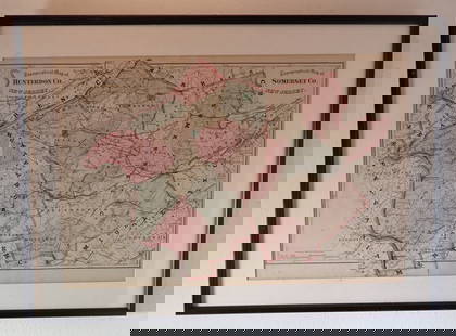
Sold20241875 Walling and Gray Pennsylvania County Maps -- Atlas of Pennsylvania Counties of Chester,Title: 1875 Walling and Gray Pennsylvania County Maps -- Atlas of Pennsylvania Counties of Chester, Dauphin, Berks, Lebanon, York and Lancaster [with] Cumberland Fraklin and Adams Cartographer: WallinSee Sold Price
Sold2017Early Framed IndentureEarly framed indenture. Berks County Pennsylvania, includes 1783 date. Frame overall 22 1/2" x 30 1/2".See Sold Price
Sold2022Map of Albany CountyFramed map of Albany County. Dated 1947. Overall 22" x 30 1/2".See Sold Price
Sold2018Map of Bucks County, Pennsylvania on Board.Dated 1895. Large area of loss, about 4" long, on the right border but it does not affect the map. Condition:(Good).Dimensions:53 - 1/2" x 53 - 1/2". Condition: (Good). Dimensions: 53 - 1/2" x 53 - 1/See Sold Price
Sold2023Chester and Delaware counties, PennsylvaniaVolumes 1-2. Genealogical and personal memoirs of Chester in Delaware County, Pennsylvania. The Lewis publishing company, 1904. Both volumes in good condition.See Sold Price
2022Map of Bucks County, 19th Century"Map of Bucks County, Pennsylvania", published by James D. Scott, modern framing. Dimensions:Sight is 16 1/4" x 26 1/4", the frame 24 1/2" x 33 1/2". Provenance:From a Bucks County collection.See Sold Price
Sold20241908 York Pennsylvania Antique Insurance Maps"Insurance Maps of York County Pennsylvania" dated 1908 published by Sanborn Map Company. Measures 25 3/4" x 22 1/2". Scale 50ft : 1 inch. Includes corrections after publication. Not all pages verifieSee Sold Price
Sold2023Map of Bucks County, Later Restrike"Map of Bucks County, Pennsylvania", published by James D. Scott, later restrike, modern framing. Dimensions:Sight is 16 1/4" x 26 1/4", the frame 24 1/2" x 33 1/2". Provenance:From a Bucks County colSee Sold Price
Jul 06Case Antiques, Inc. Auctions & AppraisalsAndrew Wyeth Signed Landscape Drawing, Brinton's MillUS$1,400(1 bid)
Jun 27Rail & Road AuctionsFour Camden & Atlantic Railroad Annual Passes - 1868, 1876, 1879, and 1889US$70
Jun 25Freeman's | Hindman[Philadelphia & Pennsylvania] Howell, Reading: A Map Of The State Of PennsylvaniaUS$3,500
21 hrs LeftEarly American History Auctions1864 $300 Bucks County Pennsylvania, Bounty 6% Bond, $300 Paid to Any Volunteer or to SubstituteUS$300
6 days LeftSwann Auction Galleries(PHILADELPHIA -- ROXBOROUGH/MANAYUNK.) John Levering. Plan of the Township of RoxboroughUS$500
21 hrs LeftEarly American History Auctions1836 Hand-Colored Map, Country Twenty Five Miles Round The City Of New-York Published by D.S. StoneUS$260
21 hrs LeftEarly American History Auctions1753 Map of the County of Lancaster Divided into its Hundreds, by Royal Mapmaker Emanuel BowenUS$280
4 days LeftBidhausLot 4 Uncut 1810s Farmers Bank of Bucks County RARE SHEET $1 1 2 3 PhiladelphiaUS$10
4 days LeftJasper521764 ACCURATE MAP OF THE COUNTY OF NORTHAMPTON antique 17.5 x 21.5" 18th CENTURYUS$75


![1875 Walling and Gray Pennsylvania County Maps -- Atlas of Pennsylvania Counties of Chester,: Title: 1875 Walling and Gray Pennsylvania County Maps -- Atlas of Pennsylvania Counties of Chester, Dauphin, Berks, Lebanon, York and Lancaster [with] Cumberland Fraklin and Adams Cartographer: Wallin](https://p1.liveauctioneers.com/5584/319185/171438575_1_x.jpg?height=310&quality=70&version=1707858212)


![[Philadelphia & Pennsylvania] Howell, Reading: A Map Of The State Of Pennsylvania (1 of 2)](https://p1.liveauctioneers.com/65/332523/179335196_1_x.jpg?height=282&quality=70&version=1717622830)


