Sold2021FRAMED ANTIQUE PENNSYLVANIA MAPFRAMED ANTIQUE PENNSYLVANIA MAP. Height: 17 1/2 & 11 1/2 in. by Width: 24 & 18 in.See Sold Price
Sold202219th C Kittanning, Pennsylvania MapItem/Description: Framed antique wall map features nine building insets including the old courthouse, churches and residences. "Map of Kittanning Armstrong Co. Penna. Surveyed, drawn & published by ThSee Sold Price
Sold2022Framed Pennsylvania Map. Westbury, Thornbury and Birmingham.Framed Pennsylvania Map. Westbury, Thornbury and Birmingham. Dimensions: H: 14.5 inches: W: 14.5 inches: Frame Height: 21.5 inches: Frame Width: 21.5 inches ---See Sold Price
Sold20231732 H. Moll New England New York, NJ. & PA Map1732 H. Moll New England New York, New Jersey, and Pennsylvania with hand coloring. Framed, 8 by 11 1/2 in acid free matt. Beautiful Map.See Sold Price
Sold2017Allen: Framed Map of New Jersey Ocean Resorts, 1898Title/Content of Map: New Jersey Ocean Resorts on the Pennsylvania Railroad Date Printed: 1898 Cartographer: Allen, Lane, and Scott Size (inches): 12 x 16 Lithographed color Antique lithographed birdsSee Sold Price
Sold20222 PC. FRAMED ANTIQUE MAPS OF ISRAEL2 PC. FRAMED ANTIQUE MAPS OF ISRAEL: Comprising; 1- Detailed Ortelius Map of the Holy Land, Based on Tilemann Stella's Extremely Rare Holy Land Maps. 1- Homann based this map of the Holy Land on the cSee Sold Price
Sold2020Framed Antique Map Orbis Vetus, Robert De VaugondyItem/Description: Old print. Map of the world by Robert de Vaugondy from 1752. Orbis vetus in utraque continente : In both the old continent / world map / Vaugondy 1752. Material: Print framed under gSee Sold Price
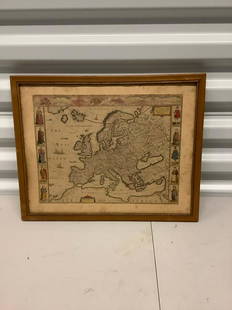
Sold20182 Framed antique maps2 Framed antique maps, probably from an old atlas, British America & The United States, map drawn & engraved by J. Rapkin, illustrations by H. Warren & illustrations by R. Wallis, Maps are 10" x 13",See Sold Price
Sold2021Framed Antique Map of Northwest Germany, DeutschlandFramed Antique Map of Northwest Germany. Nicely framed in dark wood with an interior gold border and off-white mat. Tag on the back, which is wood-covered, shows the location of the map within DeutschSee Sold Price
Sold2020FRAMED ANTIQUE MAP OF THE WORLDFRAMED ANTIQUE MAP OF THE WORLD, ROBERT DE VAUGONDY, ORBIS VET US, 1752, GEOGRAPHO REGIS ORDINARIO. PAPER IS ACID BURNED AND FOLDED IN THE CENTER. Height: 27 & 19 1/2 in. by Width: 36 1/2 & 29 in.See Sold Price
Sold2023"Orbis Romani Pars Occidentalis" Framed Antique Map by Charles Smith c1820s"Orbis Romani Pars Occidentalis" Framed Antique Map by Charles Smith c1820s.See Sold Price
Sold2024Antique Pennsylvania Map Fragment incl Wellersburg and New CentervilleNOT ELIGIBLE FOR IN-HOUSE SHIPPING. Sight: 12-1/2" high x 18-1/2" wide. Overall with frame 13-1/4" high x 19-1/4" wide. Map fragment with tears, losses, and discoloration.See Sold Price
Sold2023Group of 4 Framed Antique MapsLargest overall is 24" x 21 1/2" Condition, some scratches and scuffs and missing paint to frames, some waves and creases to mapsSee Sold Price
Sold2017NORTH AMERICA COLORED MAP, C. 1763, POSTLETHWAYTFramed antique map c. 1770, "North America, Plate 1" from the publication "Dictionary of Trade and Commerce" by Malachy Postlethwayt (British, 1707-1767), hand colored, also reading "North America, PeSee Sold Price
Sold2017NORTH AMERICA COLORED MAP, C. 1763, POSTLETHWAYTFramed antique map c. 1770, "North America, Plate III" and "Part of North America, Plate IV", from the publication "Dictionary of Trade and Commerce" by Malachy Postlethwayt (British, 1707-1767), handSee Sold Price
Sold202118th Century Florida Gulf Of Mexico Caribbean MapFramed antique map, circa 1777. Depicts map of the Gulf of Mexico, the islands, and countries adjacent. For the Rev. Dr. Robertson's History of America. Contributed by Thomas Kitchen. Published accordSee Sold Price
Sold201718thc Map: United States of America, Wilkes, 1797Framed antique map, United States of America, Published London 1797 by J. Wilkes. Engraved by Neele, 352 Strand, London. Hand colored, the map shows the United States in the Decade after the AmericanSee Sold Price
Sold2017Antique Map: John Smith's Map of VirginiaFramed antique map. John Smith's Map of Virginia. Well-engraved early 19th century reproduction. Discovered and Described by Captain John Smith, 1606. First published in 1612, this was one of the mostSee Sold Price
Sold2021Antique Map of America - Americae Nova TabulaFramed antique map. Americae nova Tabula. Having a reverse painted and gilt glass faux matte; 18.25in. X 24.25in.(image), 24.5in. X 30.75in.(framed)See Sold Price
Sold20201855 Perry Expedition Map of Gales and HurricanesFramed Antique Map, Gales and Hurricanes, from the Perry Expedition of 1855, as traced by William Redfield, including the Sandwich Islands with the track of the Kona winds. With light hand coloring.See Sold Price
Sold2021Antique Map of America - Americae Nova TabulaFramed antique map. Americae nova Tabula. Having a reverse painted and gilt glass faux matte; 18.25in. X 24.25in.(image), 24.5in. X 30.75in.(framed)See Sold Price
Sold2019Two Framed Maps: Paris by J. Shury & HavanaA framed reproduction of an 1853 map of Havana [Framed dimensions: 17 1/4 x 21 3/4 inches], and a framed antique map of Paris, engraved by J. Shury. [Framed dimensions: 16 3/8 x 22 1/8 inches]. In gooSee Sold Price
2 days LeftWorld Auction Gallery LLCFramed Reproduction of an Antique Map of Iceland by Georgio CaroloUS$30
May 26GOLDEN SUN AUCTIONS, Inc. (formerly Appraisal & Estate Sale Specialists, Inc.)William Guthries British Colonies of North America Map Circa 1800US$40
16 hrs LeftJasper52GREEK ORTHODOX SILVER BASMA ICON THEOTOKOS INTERCESSION marked 950 HAND PAINTEDUS$220
16 hrs LeftJasper52GREEK ORTHODOX SILVER BASMA ICON of SAINT St ATHANASIUS marked 950 HAND PAINTEDUS$190(1 bid)
May 26Ararity AuctionsThomson's 1817 Hand Colored Map Comparative Heights of the World's Great MountainsUS$50
Jun 16Broward Auction GalleryJoseph Conover Claghorn (DC,MD,PA,1869-1947) watercolor painting antiqueUS$10
Featured21 hrs LeftJasper52EARLY 19th c. KORAN OTTOMAN TURKISH MANUSCRIPT ILLUMINATED antique QURAN ISLAMICUS$1,900
21 hrs LeftJasper521714 MAP OF MOSCOVIA RUSSIA copper engraving ANTIQUE from Nouveau Petit AtlasUS$100
21 hrs LeftJasper521729 antique MAP OF GREAT BRITAIN Magna Britannia complectens Angliae ScotiaeUS$110


![Two Framed Maps: Paris by J. Shury & Havana: A framed reproduction of an 1853 map of Havana [Framed dimensions: 17 1/4 x 21 3/4 inches], and a framed antique map of Paris, engraved by J. Shury. [Framed dimensions: 16 3/8 x 22 1/8 inches]. In goo](https://p1.liveauctioneers.com/1221/144060/73206131_1_x.jpg?height=310&quality=70&version=1562178741)


