Sold20171950 Map of PanAm Airline Caribbean Routes1950 Map of PanAm Airline Caribbean Routes -- Pan American Flight Map New York and Caribbean. PanAm, 1950 ca., A nice folding map of Pan American Airline routes to Caribbean from New York City & MiamiSee Sold Price
Sold20191950s PanAm Route Map of Caribbean -- PanAmericanTitle/Content of Map: 1950s PanAm Route Map of Caribbean -- PanAmerican Flight Map of New York and Caribbean Date: late 1950s c. Cartographer: PanAm Size: 14x 24 in. folded out A very nice route map oSee Sold Price
Sold20201950s PanAm Route Map of Caribbean -- Pan AmericanTitle/Content of Map: 1950s PanAm Route Map of Caribbean -- Pan American Flight Map of New York and Caribbean Cartographer: PanAm Year/Place: late 1950s c. Size: 24 X 14 in. folded out A very nice rouSee Sold Price
Sold20191950s PanAm Route Map of Caribbean -- PanAmericanTitle/Content of Map: 1950s PanAm Route Map of Caribbean -- PanAmerican Flight Map of New York and Caribbean Date: late 1950s c. Cartographer: PanAm Size: 14x 24 in. folded out A very nice route map oSee Sold Price
Sold2018PanAm: Vintage Route Map of Caribbean, 1950sTitle/Content of Map: 1950s PanAm Route Map of Caribbean -- PanAmerican Flight Map of New York and Caribbeanan Date Printed: 1950s c. Cartographer: PanAm Size: 14 x 24 in. folded out A very nice routeSee Sold Price
Sold20221950s PanAm Route Map of Caribbean -- Pan American Flight Map of New York and CaribbeanTitle: 1950s PanAm Route Map of Caribbean -- Pan American Flight Map of New York and Caribbean Cartographer: PanAm Year/Place: late 1950s c. Dimensions: 24 X 14 in. folded out Description: A very niceSee Sold Price
Sold20231950s PanAm Route Map of Caribbean with Personal Notations -- PanAmerican Flight Map of New York andTitle: 1950s PanAm Route Map of Caribbean with Personal Notations -- PanAmerican Flight Map of New York and Caribbean Cartographer: PanAm Year / Place: late 1950s c. Map Dimension (in.): 14x 24 in. foSee Sold Price
Sold20181957 Route Map of Pan American Airline to Mexico,Title/Content of Map: 1957 Route Map of Pan American Airline to Mexico, Central America and Part of Caribbean -- Pan American Flight Map [to] Mexico & Central America Date: 1957 Cartographer: PanAm SiSee Sold Price
Sold20231950s American Airlines Route Map -- American Airlines Route MapTitle: 1950s American Airlines Route Map -- American Airlines Route Map Cartographer: American Airlines Year / Place: 1950s Map Dimension (in.): 12.5 X 19.2 in. joined This nice, large pictorial routeSee Sold Price
Sold20181950s PanAm Route Map of Caribbeanan -- PanAmericanTitle/Content of Map: 1950s PanAm Route Map of Caribbeanan -- PanAmerican Flight Map of New York and Caribbeanan Date: late 1950s c. Cartographer: PanAm Size: 14x 24 in. folded out A very nice route mSee Sold Price
Sold20181950s PanAm Route Map of Caribbeanan -- PanAmericanTitle/Content of Map: 1950s PanAm Route Map of Caribbeanan -- PanAmerican Flight Map of New York and Caribbeanan Date: late 1950s c. Cartographer: PanAm Size: 14x 24 in. folded out A very nice route mSee Sold Price
Sold20191957 Quantas Airline Route Map -- Quantas AirlinesReserve Reduced! Title/Content of Map: 1957 Quantas Airline Route Map -- Quantas Airlines Route Map Date: 1957 Cartographer: Quantas Airlines Size: 11.2 x 8.3 in. This is a rather interesting advertisSee Sold Price
Sold20181957 Hawaiian Airlines Convair 340 Route Map --Title/Content of Map: 1957 Hawaiian Airlines Convair 340 Route Map -- Hawaiian Airlines Route Map Date: 1957 Cartographer: Hawaiian Airlines Size: 8.5 x 11.2 in. This is an attractive advertising showSee Sold Price
Sold2018Vintage Hawaiian Airline Route Map of Hawaii, 1953Title/Content of Map: 1953 Hawaiian Airline Route Map of Hawaii -- Hawaiian Airline Map of the State of Hawaii Date Printed: 1953 Cartographer: Hawaiian Airline Size: 9.2 x 21 in This is a very nice mSee Sold Price
Sold20221950s PanAm Route Map of Caribbeanan -- PanAmerican Flight Map of New York and CaribbeananTitle: 1950s PanAm Route Map of Caribbeanan -- PanAmerican Flight Map of New York and Caribbeanan Cartographer: PanAm Year / Place: late 1950s c. Map Dimension (in.): 14x 24 in. folded out A very niceSee Sold Price
Sold20211950s PanAm Route Map of Caribbeanan -- PanAmericanTitle: 1950s PanAm Route Map of Caribbeanan -- PanAmerican Flight Map of New York and Caribbeanan Cartographer: PanAm Year / Place: late 1950s c. Map Dimension (in.): 14x 24 in. folded out A very niceSee Sold Price
Sold20231950s PanAm Route Map of South America's East Coast -- Pan American Flight Map, South America EastTitle: 1950s PanAm Route Map of South America's East Coast -- Pan American Flight Map, South America East Coast Cartographer: PanAm Year / Place: late 1950s c. Map Dimension (in.): 23.5 X 16.8 in. folSee Sold Price
Sold20231950s Hawaiian Airline Route Map of Hawaii -- Hawaiian Airline Map of the State of HawaiiTitle: 1950s Hawaiian Airline Route Map of Hawaii -- Hawaiian Airline Map of the State of Hawaii Cartographer: Hawaiian Airline Year / Place: mid 1950s Map Dimension (in.): 9.2 x 24 in This is a verySee Sold Price
Sold20231950s PanAm Route Map of Caribbeanan -- PanAmerican Flight Map of New York and CaribbeananTitle: 1950s PanAm Route Map of Caribbeanan -- PanAmerican Flight Map of New York and Caribbeanan Cartographer: PanAm Year / Place: late 1950s c. Map Dimension (in.): 14x 24 in. folded out A very niceSee Sold Price
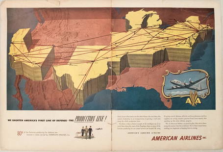
Sold20191949 American Airlines Route Map AdTitle/Content of Map: 1949 American Airlines Route Map Ad Date: 1949Cartographer: American Airlines Size: 13.6 X 21 in. when joined This is an attractive ad highlightingAmerican Airlines routes - servSee Sold Price
Sold2023Group of 18 Pan Am Airline Route Maps and MenusIncludes Rainbow Service menus, Some large tears in maps, Largest map measures 9 x 12in folded.See Sold Price
Sold2021Color pictorial bird's-eye airline route maps 1929Heading: (Aviation - pictorial route maps) Author: Title: Western Air Express: Travel by Air, Speed - Comfort - Dependability Place Published: [California?] Publisher:Western Air Express Date PuSee Sold Price
Sold2023PAN AMERICAN AIRLINES ROUTE MAP. "Fastest way between… USA & Latin America" 1935Title: PAN AMERICAN AIRLINES ROUTE MAP. "Fastest way between… USA & Latin America" 1935 Description: Consult this map for fastest way between all points in the United States and Latin America' bSee Sold Price
Sold2018United Airlines Route Map A Gay Geography of Main LineUnited Air Lines. A Gay Geography of the Main Line Airway. The Main Line Mid-Continental Airway published in 1939 route map. See Sold Price
Jun 20The Ross Art GroupOriginal Vintage Air France World Route Map Vickers Viscount Poster 1956 ConstellationUS$600
6 days LeftJasper52American Airlines System Map. Route of the Flagships. Pictorial 24"x32" c1945US$260
Jun 20The Ross Art GroupOriginal Vintage Fly TWA Jets India Pink Elephant Poster by David Klein c1960US$600(1 bid)
4 days LeftWinter Associates Three historical engraved maps of the Caribbean, ranging from 1616-1814, each hand colored, framedUS$100(1 bid)
Jun 13Swann Auction Galleries(PICTORIAL MAPS.) John Held, Jr. Motor Routes to "Real New England Inns".US$600
Jun 13Swann Auction Galleries(ATLANTIC -- NEW WORLD.) Laurent Fries; after Martin Waldseemuller. Oceani Ocidentalis seu TerreUS$3,800
2 days LeftSimpson Galleries, LLC.JULIUS BIEN (1826-1909) AN AMERICAN CIVIL WAR RECONNAISSANCE MAP, "Map of Texas and Part of NewUS$100
2 days LeftSimpson Galleries, LLC.J.H. Young (1792-1870) AN AMERICAN FEDERAL PERIOD MAP, "Mitchell's Travellers Guide Through theUS$500
2 days LeftEarly American History Auctions1853 Map, Basin of the St. Lawrence, by T. Keefer showing Natural + Artificial North American RoutesUS$220
Jun 13Swann Auction Galleries(COLONIAL NORTH AMERICA.) Herman Moll. [The Codfish Map]. To the Right Honourable John Lord Sommers.US$1,500


![1957 Route Map of Pan American Airline to Mexico,: Title/Content of Map: 1957 Route Map of Pan American Airline to Mexico, Central America and Part of Caribbean -- Pan American Flight Map [to] Mexico & Central America Date: 1957 Cartographer: PanAm Si](https://p1.liveauctioneers.com/5584/124256/63192867_1_x.jpg?height=310&quality=70&version=1530636078)


![Color pictorial bird's-eye airline route maps 1929: Heading: (Aviation - pictorial route maps) Author: Title: Western Air Express: Travel by Air, Speed - Comfort - Dependability Place Published: [California?] Publisher:Western Air Express Date Pu](https://p1.liveauctioneers.com/642/204898/103985846_1_x.jpg?height=310&quality=70&version=1621652446)


![Early California Map c1856 [179290] (1 of 1)](https://p1.liveauctioneers.com/2699/331495/178785754_1_x.jpg?height=282&quality=70&version=1717094933)


![(COLONIAL NORTH AMERICA.) Herman Moll. [The Codfish Map]. To the Right Honourable John Lord Sommers. (1 of 1)](https://p1.liveauctioneers.com/199/332329/179231618_1_x.jpg?height=282&quality=70&version=1717450360)
