Sold20221950s PanAm Route Map of Caribbeanan -- PanAmerican Flight Map of New York and CaribbeananTitle: 1950s PanAm Route Map of Caribbeanan -- PanAmerican Flight Map of New York and Caribbeanan Cartographer: PanAm Year / Place: late 1950s c. Map Dimension (in.): 14x 24 in. folded out A very niceSee Sold Price
Sold20211950s PanAm Route Map of Caribbeanan -- PanAmericanTitle: 1950s PanAm Route Map of Caribbeanan -- PanAmerican Flight Map of New York and Caribbeanan Cartographer: PanAm Year / Place: late 1950s c. Map Dimension (in.): 14x 24 in. folded out A very niceSee Sold Price
Sold20181950s PanAm Route Map of Caribbeanan -- PanAmericanTitle/Content of Map: 1950s PanAm Route Map of Caribbeanan -- PanAmerican Flight Map of New York and Caribbeanan Date: late 1950s c. Cartographer: PanAm Size: 14x 24 in. folded out A very nice route mSee Sold Price
Sold20181950s PanAm Route Map of Caribbeanan -- PanAmericanTitle/Content of Map: 1950s PanAm Route Map of Caribbeanan -- PanAmerican Flight Map of New York and Caribbeanan Date: late 1950s c. Cartographer: PanAm Size: 14x 24 in. folded out A very nice route mSee Sold Price
Sold20231950s PanAm Route Map of Caribbeanan -- PanAmerican Flight Map of New York and CaribbeananTitle: 1950s PanAm Route Map of Caribbeanan -- PanAmerican Flight Map of New York and Caribbeanan Cartographer: PanAm Year / Place: late 1950s c. Map Dimension (in.): 14x 24 in. folded out A very niceSee Sold Price
Sold20191950s PanAm Route Map of Caribbean -- PanAmericanTitle/Content of Map: 1950s PanAm Route Map of Caribbean -- PanAmerican Flight Map of New York and Caribbean Date: late 1950s c. Cartographer: PanAm Size: 14x 24 in. folded out A very nice route map oSee Sold Price
Sold20191950s PanAm Route Map of Caribbean -- PanAmericanTitle/Content of Map: 1950s PanAm Route Map of Caribbean -- PanAmerican Flight Map of New York and Caribbean Date: late 1950s c. Cartographer: PanAm Size: 14x 24 in. folded out A very nice route map oSee Sold Price
Sold20201950s PanAm Route Map of Caribbean -- Pan AmericanTitle/Content of Map: 1950s PanAm Route Map of Caribbean -- Pan American Flight Map of New York and Caribbean Cartographer: PanAm Year/Place: late 1950s c. Size: 24 X 14 in. folded out A very nice rouSee Sold Price
Sold20221950s PanAm Route Map of Caribbean -- Pan American Flight Map of New York and CaribbeanTitle: 1950s PanAm Route Map of Caribbean -- Pan American Flight Map of New York and Caribbean Cartographer: PanAm Year/Place: late 1950s c. Dimensions: 24 X 14 in. folded out Description: A very niceSee Sold Price
Sold2018PanAm: Vintage Route Map of Caribbean, 1950sTitle/Content of Map: 1950s PanAm Route Map of Caribbean -- PanAmerican Flight Map of New York and Caribbeanan Date Printed: 1950s c. Cartographer: PanAm Size: 14 x 24 in. folded out A very nice routeSee Sold Price
Sold20231950s PanAm Route Map of Caribbean with Personal Notations -- PanAmerican Flight Map of New York andTitle: 1950s PanAm Route Map of Caribbean with Personal Notations -- PanAmerican Flight Map of New York and Caribbean Cartographer: PanAm Year / Place: late 1950s c. Map Dimension (in.): 14x 24 in. foSee Sold Price
Sold20231950s PanAm Route Map of South America's East Coast -- Pan American Flight Map, South America EastTitle: 1950s PanAm Route Map of South America's East Coast -- Pan American Flight Map, South America East Coast Cartographer: PanAm Year / Place: late 1950s c. Map Dimension (in.): 23.5 X 16.8 in. folSee Sold Price
Sold20231950s Pan Am World Route Maps -- Route Maps Pan AmericanTitle: 1950s Pan Am World Route Maps -- Route Maps Pan American Cartographer: PanAm Year / Place: late 1950s c. Map Dimension (in.): 9 x 12 in. single page This is an outstanding 6 double page fold-ouSee Sold Price
Sold2018Pan American Airways Circa 1950's System Route MapPan American Airways Circa 1950's System Route MapSee Sold Price
Sold20171950 Map of PanAm Airline Caribbean Routes1950 Map of PanAm Airline Caribbean Routes -- Pan American Flight Map New York and Caribbean. PanAm, 1950 ca., A nice folding map of Pan American Airline routes to Caribbean from New York City & MiamiSee Sold Price
Sold20181957 Route Map of Pan American Airline to Mexico,Title/Content of Map: 1957 Route Map of Pan American Airline to Mexico, Central America and Part of Caribbean -- Pan American Flight Map [to] Mexico & Central America Date: 1957 Cartographer: PanAm SiSee Sold Price
Sold20231950s Hawaiian Airline Route Map of Hawaii -- Hawaiian Airline Map of the State of HawaiiTitle: 1950s Hawaiian Airline Route Map of Hawaii -- Hawaiian Airline Map of the State of Hawaii Cartographer: Hawaiian Airline Year / Place: mid 1950s Map Dimension (in.): 9.2 x 24 in This is a verySee Sold Price
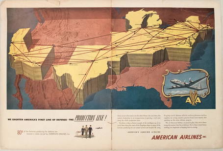
Sold20231950s American Airlines Route Map -- American Airlines Route MapTitle: 1950s American Airlines Route Map -- American Airlines Route Map Cartographer: American Airlines Year / Place: 1950s Map Dimension (in.): 12.5 X 19.2 in. joined This nice, large pictorial routeSee Sold Price
Sold2023PAN AMERICAN AIRLINES ROUTE MAP. "Fastest way between… USA & Latin America" 1935Title: PAN AMERICAN AIRLINES ROUTE MAP. "Fastest way between… USA & Latin America" 1935 Description: Consult this map for fastest way between all points in the United States and Latin America' bSee Sold Price
Sold2018Pan American Jet Clipper Route Maps 1964Pan American jet clipper route maps, dated 8/64.See Sold Price
Sold2018North Atlantic Airlines Route Map Information Booklet CNorth Atlantic Airlines Route Map Information Booklet Circa 1950sSee Sold Price
Sold20201956 Pan Am World and Germany Route Map -- WillkommenTitle: 1956 Pan Am World and Germany Route Map -- Willkommen an Bord! Pan Am Cartographer: Pan American Airways Year / Place: 1956 Map Dimension (in.): 15.3 X 8.3 in. A very nice pictorial map of theSee Sold Price
Sold2023Original Vintage 1950s Tour de France Map Poster RouteAnonymous - France Tour de France (Map Poster) Offset 1950 27.1 x 20 in. (69 x 51 cm) Printer: Mont-Louis, Clermont Condition Details: (A-) was folded, linen-backed #France #Travel #Tour de France #BiSee Sold Price
Sold2023Original Vintage 1950s Tour de France Map Poster RouteAnonymous - France Tour de France (Map Poster) Offset 1958 24 x 19.6 in. (61 x 50 cm) Printer: Dupont, Paris Condition Details: (B+/A-) was folded, linen-backed, small tears at the folds #France #TravSee Sold Price
2 days LeftPotter & Potter AuctionsPan American World Airways. Four Central American and Carib...US$250
Jun 29JM Hobby Supply and Railroad Artifact AuctionsFlorence & Cripple Creek RR Public Timetable-September 1894US$400
2 days LeftPotter & Potter AuctionsFLACHMAN, Chuck. Being a Map of Saint Louis / Home of Anheu...US$100
2 days LeftPotter & Potter AuctionsLINDGREN, Jolly (1895-1952). A Hysterical Map of Yellowstone Park and the Jackson Hole CountryUS$125
8 hrs LeftJasper521578 BIBLE ILLUSTRATED by T. STIMMER BIBLIA SACRA antique 16th CENTURY PIGSKINUS$1,400
Jun 07Freeman's | Hindman[MORMONS]. MILLROY & HAYES (fl. 1899). Route of the Mormon Pioneers from Nauvoo to Great Salt Lake,US$300
2 days LeftPotter & Potter AuctionsUnited Airlines DC-8 Display Mock-Up. Circa 1950s. Tempera ...US$125
8 hrs LeftJasper521882 UNEXPLORED BALUCHISTAN by ERNEST FLOYER antique ILLUSTRATED w/ MAP EnglishUS$320
2 days LeftPotter & Potter AuctionsPan American Airways World System Map. 1956. Art by John Br...US$200
2 days LeftPotter & Potter AuctionsCAMPOS, Florencio Molina (1891 – 1959). Argentina / Panagra...US$125(1 bid)
Featured1 day LeftJasper52EUROPE. Political. Austro-Hungarian Monarchy. Shipping routes. JOHNSTON 1906 mapUS$20
1 day LeftJasper52North Sea sea chart. Ports lighthouses mail routes. UK Norway &c LARGE 1952 mapUS$40
Featured9 hrs LeftJasper52Mitchell’s Map of Asia showing travel routes London, India, China & Japan, 1860US$45
2 days LeftPotter & Potter AuctionsAir France / Reseau Aerien Postal. 1948. Paris: Perceval. L...US$150


![1957 Route Map of Pan American Airline to Mexico,: Title/Content of Map: 1957 Route Map of Pan American Airline to Mexico, Central America and Part of Caribbean -- Pan American Flight Map [to] Mexico & Central America Date: 1957 Cartographer: PanAm Si](https://p1.liveauctioneers.com/5584/124256/63192867_1_x.jpg?height=310&quality=70&version=1530636078)


![[MORMONS]. MILLROY & HAYES (fl. 1899). Route of the Mormon Pioneers from Nauvoo to Great Salt Lake, (1 of 2)](https://p1.liveauctioneers.com/197/329395/177650560_1_x.jpg?height=282&quality=70&version=1715364962)


