Sold2017Thomson: Map of Hindoostan, 1814Map: Hindoostan Cartographer: Thomson Place & Date: Edinburgh / 1814/1817 Size: 24 1/8" x 22 5/8" Condition: light overprinting and minor spotting The magnificent India map Thomson's influential New GSee Sold Price
Sold20201814 Thomson Map of St. Vincent and Barbados -- WestTitle/Content of Map: 1814 Thomson Map of St. Vincent and Barbados -- West India Islands. St. Vincent [on sheet with] Barbadoes Cartographer: J Thomson Year/Place: 1814, Edinburgh Size: 19.7 X 23 in.See Sold Price
Sold2023Thomson, John (Pub) 1825 Map. Hindoostan. IndiaCopper Engraved Map Published 1825 by John Thomson, Edinburgh for "The Edinburgh School Atlas" by N. R. Hewitt. Maps Engraved by Hewitt. Original Outline Hand Colour. Rare. Paper Size: 10.5 x 8 inch (See Sold Price
Sold2017Thomson: Antique Map of British India, 1814Map: British India Southern Part/British India Northern Part Cartographer: Thomson Place & Date: Edinburgh / 1814/1817 Size: 24 1/8" x 22 5/8" Condition: overall age-toning and spotting; repaired spliSee Sold Price
Sold2017Thomson: Antique Map of North America, 1814Map: North America Cartographer: Thomson Place & Date: Edinburgh / 1814/1817 Size: 23 5/8" x 19 1/2" Condition: outline color; overall age toning with some browning along centerfold and minor spottingSee Sold Price
Sold2018Thomson: Antique Map of Asiatic Turkey, 1814The magnificent Middle East map from Thomson's New General Atlas encompasses in great detail the Turkish empire's Asian territories from the Aegean to its borders with Persia and Russia. Cartographer:See Sold Price
Sold2017Thomson: Antique World Map, Mercator's Projection, 1814Map: Chart of the World on Mercator's Projection Cartographer: Thomson Place & Date: Edinburgh / 1814 Size: 20" x 17 3/4" Condition: b&w; overall age toning; browning along centerfold; two small, repaSee Sold Price
Sold2020Thomson: South America, 1814Title/Content of Map: Thomson: South America, 1814 Date Printed: 1814, Edinburgh Cartographer: John Thomson Size: 20" x 23" A finely engraved and marvelously detailed map of the continent with excelleSee Sold Price
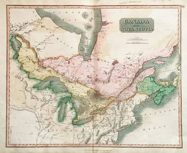
Sold2018Thomson: Antique Map of Canada & Nova Scotia, 1814Map: Canada and Nova Scotia Cartographer: Thomson Place & Date: Edinburgh / 1814/1817 Size: 23 3/4" x 19 1/8" Condition: wash color; light browning and minor staining in margins The superbly detailedSee Sold Price
Sold2017Thomson: Antique Map of New Holland (Australia), 1814Map: New Holland and Asiatic Islands Cartographer: Thomson Place & Date: Edinburgh / 1814/1817 Size: 24 1/4" x 19 3/4" Condition: overprinting and some staining; repaired splits along centerfold and nSee Sold Price
Sold2018Thomson: Antique Map of The Venetian States, 1814Title/Content of Map: The Venetian States Cartographer: Thomson Place & Date: Edinburgh / 1814/1817 Size: 19 1/4" x 23 1/4" Condition: light overprinting; minor spotting; some browning along the centeSee Sold Price
Sold2017Thomson: Map of Arabia, Egypt, Abyssinia, Red Sea, 1814Map: Arabia, Egypt, Abyssinia, Red Sea Cartographer: Thomson Place & Date: Edinburgh / 1814/1817 Size: 23 1/4" x 19 7/8" Condition: some spotting and age toning The beautifully detailed map of ArabiaSee Sold Price
Sold2020J. Thomson map- ''America''A Map of ''America,'' John Thomson,- engraving depicting both North and South America, from Thomson's ''New General Atlas'', 1814. 18 x 20 1/4''See Sold Price
Sold2022New Holland & Asiatic islands Australia New Zealand Polynesia THOMSON 1817 mapTITLE/CONTENT OF MAP: 'New Holland and Asiatic islands' DATE PRINTED: Published in 1817. Engraved in 1814; this date is marked on the map IMAGE SIZE: Approx 52.0 x 64.0cm, 20.5 x 25.25 inches (Large);See Sold Price
Sold20241814 ANTIQUE MAP RUSSIAN EMPIRE large 21 by 28"Size 21 by 28" Printed in London in 1814 by John Thomson & Co. Very good condition (553) . Reserve: $110.00 Shipping: Domestic: Flat-rate of $25.00 to anywhere within the contiguous U.S. InternatiSee Sold Price
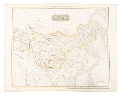
Sold2019Map of Tartary comprising most of AsiaHeading: (Maps) Author: Thomson, John Title: Tartary Place Published: Edinburgh Publisher: Date Published: 1814 Description: Engraved map, hand-colored in outline. 49.8x59.5See Sold Price
Sold20231814 Aaron Arrowsmith map. Judah & IsraelAaron Arrowsmith map. Judah & Israel. Title: Judah & Israel. Illustrating the Books of Kings. Production date: 1814. Drawn under the direction of M. Arrowsmith (1750- 1823). Thomson sculpt. PublishedSee Sold Price
Sold2019Two Maps from John Thomson's New General Atlas, "NorthTwo Maps from John Thomson's New General Atlas, "North America," 1814, and "Poland," America- H. - 21 1/2 in., W. - 28 1/2 in., Poland- H.- 21 in., W.- 27 1/2 in.See Sold Price
Sold20181814 Findlay Map of India and Sri Lanka -- HindoostanTitle/Content of Map: 1814 Findlay Map of India and Sri Lanka -- Hindoostan Date: 1814, London Cartographer: A Findlay Size: 10 x 7.4 in. This is a very nice map of India and Ceylon (Sri Lanka). The pSee Sold Price
Sold20231814 Thomson New General Atlas The British Channel MapSome small tears along edges, Measures 21 1/2 x 28 1/2 inches.See Sold Price
Sold2019Thomson: South America, 1817Map Title: South America Cartographer: Thomson Place/Date: Edinburgh / 1814/1817 Size: 20" x 23" Condition: outline color; overprinting, overall age toning, and some browning especially along centerfoSee Sold Price
Sold2018Thomson: Upper & Lower Canada, Nova ScotiaMap: Canada and Nova Scotia Cartographer: Thomson Place/Date: Edinburgh / 1814/1817 Size: 23 3/4" x 19 1/8" Condition: wash color; light browning along centerfold and in margins; some staining in uppeSee Sold Price
Sold2018Thomson: St. Vincent and BarbadosReserve Reduced! Title of Map: West India Islands. St. Vincent. Barbadoes. Cartographer: John Thomson Place / Date: Edinburgh / 1814/1817 Size: 23 3/4" x 20" Condition: overall age toning; browning anSee Sold Price
Sold2019Thomson: South America, 1814Map Title: South America Cartographer: Thomson Place/Date: Edinburgh / 1814 Size: 20" x 23" Condition: outline color; very light age toning otherwise in excellent condition A finely engraved and marveSee Sold Price
5 days LeftJasper521806 Cary Map of India, Pakistan and Sri Lanka -- A New Map of Hindoostan, from the LatestUS$70
6 days LeftJasper52Islands in the Pacific Ocean. Owhyhee/Hawaii Otaheite/Tahiti. THOMSON 1817 mapUS$70
6 days LeftJasper52Islands in the Pacific Ocean. Hawaii. Phantom Jardines islands. THOMSON 1830 mapUS$75
6 days LeftJasper52Islands in the Pacific Ocean. Owhyhee/Hawaii Otaheite/Tahiti. THOMSON 1817 mapUS$85
BonhamsBOWYER (ROBERT) An Illustrated Record of Important Events in the Annals of Europe, During the La...£800
Jun 23Schilb Antiquarian Rare Books1816 Napoleonic War ENGLISH 1ed Campaigns Russia Invasion Labaume MAPS NapoleonUS$2(2 bids)
BonhamsMANUSCRIPT JOURNAL – WATERLOO, SOUTH AFRICA and INDIA Manuscript journal of Edward Nugen...£800(3 bids)
BonhamsSHOBERL (FREDERIC) The World in Miniature, FIRST EDITION, COMPLETE IN 43 VOLUMES, R. Ackerman, [...£3,000(1 bid)
BonhamsSMITH (CHARLES HAMILTON) Selections of the Ancient Costume of Great Britain and Ireland, FIRST E...£400
BonhamsWATHEN (JAMES) Journal of a Voyage in 1811 and 1812, to Madras and China; Returning by the Cape ...£400(1 bid)


![1814 Thomson Map of St. Vincent and Barbados -- West: Title/Content of Map: 1814 Thomson Map of St. Vincent and Barbados -- West India Islands. St. Vincent [on sheet with] Barbadoes Cartographer: J Thomson Year/Place: 1814, Edinburgh Size: 19.7 X 23 in.](https://p1.liveauctioneers.com/5584/173638/87405897_1_x.jpg?height=310&quality=70&version=1594766493)


![[India] Rennell, James, Major (1 of 2)](https://p1.liveauctioneers.com/94/330664/178342480_1_x.jpg?height=282&quality=70&version=1716466933)


