Sold2017Bradford: Antique Map of Atlantic Ocean, 1835Map: Atlantic Ocean Date Printed: 1835 Cartographer: T. G. Bradford Material/Medium: Paper Size: 10" x 13" Hand colored outlines. Published in Boston. From 'A Comprehensive Atlas Geographical, HistoriSee Sold Price
Sold2023Martin, Benjamin 1772 Antique Map. Atlantic Ocean with Europe Africa America"A New Geographical Map or Chart of the Atlantic Ocean with the Continents of Europe, Africa & America &c on the East & West Side of it" Copper Engraved Map Published 1772, London for "The Young GentlSee Sold Price
Sold2023Martin, Benjamin 1772 Antique Map. Atlantic Ocean with Europe Africa America"A New Geographical Map or Chart of the Atlantic Ocean with the Continents of Europe, Africa & America &c on the East & West Side of it" Copper Engraved Map Published 1772, London for "The Young GentlSee Sold Price
Sold2018Bartholomew: Antique Map of Atlantic Ocean, 1879Title/Content of Map: Atlantic Ocean &C. Date Printed: 1879 Cartographer: BARTHOLOMEW, J. Size (inches): 10.5X15 Dry."shewing the communication between Europe, North America and the Pacific." Shows unSee Sold Price
Sold2018Bellin: Antique Map of Northern Atlantic Ocean, 1746Title/Content of Map: Carte de l'Ocean Occidental Cartographer: Bellin Place & Date: Paris / 1746/1760 Size: 18" x 12 1/2" Condition: b&w; old folds as published; light overall age toning Bellin's magSee Sold Price
Sold2017Bradford: Antique Map of Louisiana, 1838Title/Content of Map: Louisiana by Bradford Date Printed: 1838/1841 Cartographer: Thomas G. Bradford Material/Medium: Paper Size: 16 1/2" x 13" Hand colored. A General Atlas of the World with a SeparaSee Sold Price
Sold2017Bradford: Antique Map of Ohio, 1838Title/Content of Map: Ohio by Bradford Date Printed: 1838/1841 Cartographer: Thomas G. Bradford Material/Medium: Paper Size: 13" x 16 1/2" Hand colored. A General Atlas of the World with a Separate MaSee Sold Price
Sold2017Bradford: Antique Map of Philadelphia, 1838Title/Content of Map: Philadelphia b Bradford Date Printed: 1838/41 Cartographer: Thomas G. Bradford Material/Medium: Paper Size: 13" x 16 3/4" Condition: Excellent Hand colored. A General Atlas of thSee Sold Price
Sold2017Bradford: Antique Map of Maine, 1838Title/Content of Map: Maine by Bradford Date Printed: 1838/1841 Cartographer: Thomas G. Bradford Material/Medium: Paper Size: 13" x 16 1/2" Hand colored. A General Atlas of the World with a Separate MSee Sold Price
Sold2017Bradford: Antique Map of Tennessee, 1838Title/Content of Map: Tennessee by Bradford Date Printed: 1838/1841 Cartographer: Thomas G. Bradford Material/Medium: Paper Size: 13" x 16 1/2" Hand colored. A General Atlas of the World with a SeparaSee Sold Price
Sold2017Bradford: Antique Map of Philadelphia, 1838Title/Content of Map: Philadelphia by Bradford Date Printed: 1838/1841 Cartographer: Thomas G. Bradford Material/Medium: Paper Size: 16 3/4" x 13" Hand colored. A General Atlas of the World with a sepSee Sold Price
Sold2017Bradford: Antique Map of Kentucky, 1838Title/Content of Map: Kentucky by Bradford Date Printed: 1838/1841 Cartographer: Thomas G. Bradford Material/Medium: Paper Size: 16 1/2" x 13" Hand colored. A General Atlas of the World with a SeparatSee Sold Price
Sold2017Bradford: Antique Map of Arkansas, 1838Title/Content of Map: Arkansas by Bradford Date Printed: 1838/1841 Cartographer: Thomas G. Bradford Material/Medium: Paper Size: 13" x 16 1/2" Hand colored. A General Atlas of the World with a SeparatSee Sold Price
Sold2017Bradford: Antique Map of Illinois, 1838Title/Content of Map: Illinois by Bradford Date Printed: 1838/1841 Cartographer: Thomas G. Bradford Material/Medium: Paper Size: 13" x 16 1/2" Hand colored. A General Atlas of the World with a SeparatSee Sold Price
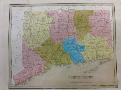
Sold2018Bradford: Antique Map of Connecticut, 1838Title/Content of Map: Connecticut by Bradford Date Printed: 1838 Cartographer: Thomas G. Bradford Size: 14" x17" Material/Medium: Paper Provenance: New York A General Atlas of the World with a separatSee Sold Price
Sold2017Bradford: Antique Map of Alabama, 1838Title/Content of Map: Alabama by Bradford Date Printed: 1838/1841 Cartographer: Thomas G. Bradford Material/Medium: Paper Size: 13" x 16 1/2" Hand colored. A General Atlas of the World with a SeparateSee Sold Price
Sold2017Bradford: Antique Map of Pennsylvania, 1838Title/Content of Map: Pennsylvania by Bradford Date Printed: 1838/1841 Cartographer: Thomas G. Bradford Material/Medium: Paper Size: 16 1/2" x 13" Hand colored. A General Atlas of the World with a SepSee Sold Price
Sold2017Bradford: Antique Map of Indiana, 1838Title/Content of Map: Indiana by Bradford Date Printed: 1838/1841 Cartographer: Thomas G. Bradford Material/Medium: Paper Size: 13" x 16 1/2" Hand colored. A General Atlas of the World with a SeparateSee Sold Price
Sold2017Bradford: Antique Map of Massachusets, 1838Title/Content of Map: Massachusets by Bradford Date Printed: 1838/1841 Cartographer: Thomas G. Bradford Material/Medium: Paper Size: 13" x 16 1/2" Hand colored. A General Atlas of the World with a SepSee Sold Price
2017Bradford: Antique Map of Conneticut, 1838Title/Content of Map: Conneticut by Bradford Date Printed: 1838/1841 Cartographer: Thomas G. Bradford Material/Medium: Paper Size: 13" x 16 1/2" Hand colored. A General Atlas of the World with a SeparSee Sold Price
Sold2017Bradford: Antique Map of Vermont, 1838Title/Content of Map: Vermont by Bradford Date Printed: 1838/1841 Cartographer: Thomas G. Bradford Material/Medium: Paper Size: 13" x 15" A General Atlas of the World with a seperate Map of each of thSee Sold Price
Sold2017van der Aa: Antique Explorers Map of the Atlantic OceanTitle: H. Benzos Scheep-togt uit Italie over Spanje na de Westindize Eylanden, en Kusten van't Zuider America. Lovely 1707 explorers' map set in a decorative border Map maker: Pieter van der Aa PlaceSee Sold Price
Sold2017Bradford: Antique Map of Iowa & Wisconsin, 1838Title/Content of Map: Rare and Important early Iowa and Wisconsin Date Printed: 1838/1841 Cartographer: Thomas G. Bradford Material/Medium: Paper Size: 13" x 16 1/2" Hand colored. A General Atlas of tSee Sold Price
Sold2017T.G Bradford: Antique Map of United States, 1838Title: Map of United States by T.G Bradford Date: 1838 Medium: Wax Engraving Dimensions (in): 25 x 16 Condition: Excellent Condition Thomas G. Bradford was the author of the Illustrated Atlas of the USee Sold Price
Jun 08Early American History Auctions1853 Map, Basin of the St. Lawrence, by T. Keefer showing Natural + Artificial North American RoutesUS$220
Featured5 days LeftJasper521831 Woodbridge Map of South America and Africa -- Comparative, Geographical & Statistical Map ofUS$70
6 days LeftJasper52World War 2 Europe Battle of the Atlantic 1939-43 Axis Expansion limits 1959 mapUS$15
5 days LeftJasper521775-1780 South and Central America includes The Southern U.S. with Trade Winds. by Bonne & RaynalUS$120
6 days LeftJasper52COLONIAL GABON & CONGO. Afrique équatoriale française. Brazzaville plan 1938 mapUS$20
6 days LeftJasper52COLONIAL GABON & CONGO. Afrique équatoriale française. Brazzaville plan 1929 mapUS$20
6 days LeftJasper52Coste Orientale d’Afrique…' South Africa. Mozambique channel. BELLIN 1746 mapUS$25
Featured6 days LeftJasper52Coste Occidentale d’Afrique…' Namibia South Africa Angola coast BELLIN 1746 mapUS$45
6 days LeftJasper52Coste Occidentale d’Afrique…' West Africa. Gulf of Guinea. BELLIN 1746 mapUS$55