Sold2015U.S. Coast Survey Map of South Farallon Island and San(lot of 2) Alexander Dallas Bache (American, 1806 - 1867), South Farallon Island, 1855, and San Clemente Island, 1856, U.S. Coast Survey hand-colored copper engraved maps, overalls (with frames): 18"hSee Sold Price
Sold2017Florida Lithograph MapU.S. Coast Survey Sketch F Showing the Progress of the Survey in Section V. A.D. Bache (1806-1867). Lithographed map. Washington, D.C., 1855. 23 x 16 1/2 inches visible, 27 1/4 x 21 1/2 inches framedSee Sold Price
Sold2022LOT (3) VOLS. TREATISE PRACTICAL SURVEYING W/CHARTSLOT (3) VOLS. TREATISE PRACTICAL SURVEYING W/CHARTS 1792, TREATISE PRACTICAL SURVEYING W/CHARTS 1806, AMERICAN UNIVERSAL GEOGRAPHY BOSTON W/PULL-OUT MAPS & CHARTS 1812See Sold Price
Sold2017USCGS: Antique Coastal Chart Map of Suisun Bay, 1870Title/Content of Map: 'Suisunbay California from a Trigonometrical survey under the direction of A.D. Bache, Superintendent of the survey of the Coast of the United States Published by 1872' COASTAL CSee Sold Price
Sold2022c. 1781 Captain Cook Voyages Map, London by Alexander HoggHistoric Maps "A Plan of Success Bay in Strait Le Maire / A Chart of the S.E. part of Terra del Fuego... by Captn. Cook 1769" c. 1781, A "Dual" Map from Captain Cook's Voyages, titled: "A Plan of SuccSee Sold Price
Sold2022c. 1781 Captain Cook Voyages Map, London by Alexander HoggHistoric Maps "A Plan of Success Bay in Strait Le Maire / A Chart of the S.E. part of Terra del Fuego... by Captn. Cook 1769" c. 1781, Dual Map from Captain Cook's Voyages, titled: "A Plan of SuccessSee Sold Price
Sold2016(2) ANTIQUE IRELAND MAPSCarte D' Irlande map published in 1867 by Alvin J. Johnson New York. Measures 10 3/4" x 15 3/4" (Framed 19 1/2" x 23 1/2") and a Jacques Nicolas Bellin A Chart of Ireland 1803 hand colored map. MeasurSee Sold Price
Sold2021Antique Coast Survey Map of the Atchafalaya BayAntique Coast Survey Map of the Atchafalaya Bay , "Preliminary Chart of Atchafalaya Bay Louisiana... A.D. Bache, Superintendant", 1858, lithograph, with later hand-coloring, sight 24 1/2 in. x 31 1/4See Sold Price
Sold2018Mare Island StraitsTitle/Content of Map: Mare Island Straits Date Printed: 1851 Cartographer: BACHE, A.D. Size: 6.5X12.5 Chart of Mare Island, straits with soundings and "Site of vallejo Seat of Government of CaliforniaSee Sold Price
Sold2021Three South Carolina MapsPreliminary Chart of Port Royal Entrance, Beaufort Chechessee and Colleton Rivers... U.S. Coast Survey Office, Superintendent A. D. Bache, triangulation by C. O. Boutelle... 1859, single sheet, engravSee Sold Price
Sold2021RINGGOLD - Bay of San Francisco Map 1850RINGGOLD, Cadwalader (1802-1867, surveyor). Chart of the Bay of San Pablo Straits of Carquines and part of the Bay of San Francisco California by ... Ringgold assisited by Simon F. Blunt ... ProjectedSee Sold Price
Sold2023Lysons, Daniel & Samuel 1822 Map of Dartmouth Haven, Devon, UK"Dartmouth Haven &c. From a Chart Drawn in the Reign of K. Hen. VIII..." Copper Plate Published 1806-22, London for "Magna Britannia; Being A Concise Topographical Account of The Several Counties of GSee Sold Price
Sold20151867 Map of California and NevadaLeander Ransom & Amos Doolittle: A New Map of the States of California and Nevada, Exhibiting the Rivers, Lakes, Bays and Islands, with the principal Towns, Roads, Railroads and Transit Routes to theSee Sold Price
Sold2022LARGE ARCHITECTS PRINT / MAP / CHART CABINETFantastic very large Architectural draftsman/chart/map/print flat file - George III-Style mahogany with satinwood inlay, inset tooled leather top. 8 Drawer over 4 drawer. from the Audubon Gallery, KinSee Sold Price
Sold2023TWO MARTHA'S VINEYARD MAPS/CHARTS 19th Century 28.5” x 20.5” and 18.5” x 14”TWO MARTHA'S VINEYARD MAPS/CHARTS19th Century“Muskeget Channel” and “Edgartown Harbor”.28.5” x 20.5” and 18.5” x 14”. Framed 31” x 23” and 2See Sold Price
Sold2019Attributed to Horatio McCulloch "Walking down the Road"Attributed to HORATIO MCCULLOCH (Scottish 1806-1867) "Walking Down the Road" Oil on canvas. 24 1/4 x 36 inches; Frame: 30 1/4 x 42 1/8 inches. No visible signature. Partial label verso lower left cornSee Sold Price
Sold20212 Antique 19thC. Leather Family Bibles 1825Lot of two antique Bibles. With ornate gold embossed details on spine, gorgeous marbled endpapers. Marked Family Bibles of previous owners. Includes maps, charts, and etchings. Publisher: BrattleboroSee Sold Price
Sold2023Horatio McCulloch, Sunset Over the WaterHoratio McCulloch (Scottish, 1806-1867), oil on canvas depicting two men at the edge of the water, one gesturing toward the setting sun, signed l.l., 23" x 35" canvas, 33 1/4" x 45 1/4" framed.See Sold Price
Sold2024NW Coast of America & NE Coast of Asia… ROBERTS / DELAROCHETTE. Pacific 1794 mapTITLE/CONTENT OF MAP: 'Chart of the N.W.Coast of America and the N.E. Coast of Asia explored in the years 1778 and 1779 prepared by Lieut. Henry Robert under the immediate inspection of Capt. Cook' DASee Sold Price
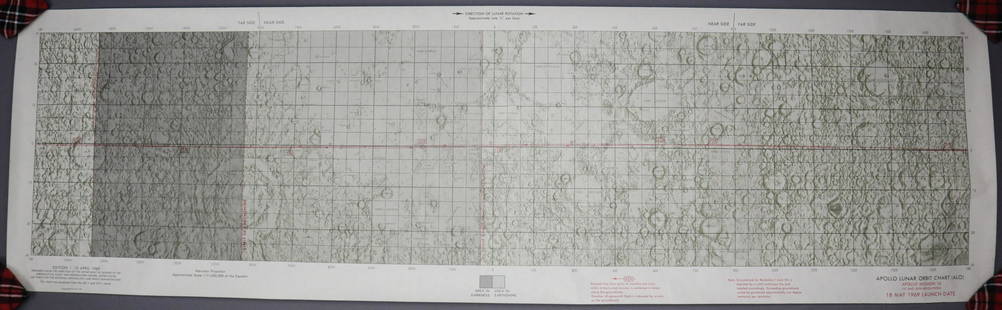
Sold2023Apollo 10 Lunar Orbit ChartThis item is from the personal collection of Grumman Test Astronaut Glennon Kingsley. This original Apollo 10 Lunar Orbit Chart is dated 10 April 1969 for the 18 May 1969 Launch Date. This map chart sSee Sold Price
Sold20241766 Emanuel Bowen "The Maps And Charts Of The Modern Part Of The Universal History"Printed for T. Osborne, A. Millar, J Rivington, B. Law And Co., T. Longman, C. Ware, and S. BladonSee Sold Price
Sold2021MITCHELL - New General Atlas [35 American maps] 1867MITCHELL, S. Augustus, Jr.. Mitchell's New General Atlas, containing maps of various countries of the world, plans of cities, etc., ... together with valuable statistical tables. Philadelphia: S. AuguSee Sold Price
Sold2021Land office report w/ large colored map 1867Heading: (General Land Office) Author: Title: Report of the Commissioner of the General Land Office for the Year 1866. Place Published: [Washington, D.C.] Publisher:Government Printing Office DaSee Sold Price
BonhamsANSON, GEORGE, BARON. 1697-1762. A Voyage Round the World, in the Years MDCCXL, I, II, III, IV. ...US$800
18 hrs LeftJasper521806 Cary Map of India, Pakistan and Sri Lanka -- A New Map of Hindoostan, from the LatestUS$70
17 hrs LeftJasper521816 MAP NORTHERN PART OF RUSSIA or MUSCOVY in EUROPE copper engraving ANTIQUEUS$35
Featured2 days LeftJasper52Marshall Islands North Pacific Ocean Micronesia ADMIRALTY chart 1891 (1953) mapUS$120
2 days LeftJasper52Hawaiian–Emperor seamount chain Midway-Kauai ADMIRALTY chart 1950 (1955) mapUS$140(1 bid)
2 days LeftJasper52South west Pacific Ocean Melanesia Polynesia ADMIRALTY sea chart 1875 (1968) mapUS$120
2 days LeftJasper52Caroline Islands Palau Malakal Ngulu Angaur. ADMIRALTY sea chart 1928 (1956) mapUS$120
Featured2 days LeftJasper52Fiji - Samoa Melanesia Polynesia Pacific ADMIRALTY sea chart 1896 (1954) mapUS$140
Jun 26University Archives(2) Apollo XI Orbital Photo Charts Likely Used in Training, 58" in Length!US$200
2 days LeftJasper52Mariana Islands. Guam Saipan Tinian. ADMIRALTY sea chart 1953 (1955) old mapUS$120
2 days LeftJasper52Islands in the Pacific Ocean. Hawaii. Phantom Jardines islands. THOMSON 1830 mapUS$75
BonhamsWight, Alexander An Inquiry into the Rise and Progress of Parliament chiefly in Scotland£90(2 bids)


![MITCHELL - New General Atlas [35 American maps] 1867: MITCHELL, S. Augustus, Jr.. Mitchell's New General Atlas, containing maps of various countries of the world, plans of cities, etc., ... together with valuable statistical tables. Philadelphia: S. Augu](https://p1.liveauctioneers.com/7533/208644/106251073_1_x.jpg?height=310&quality=70&version=1624641782)

![Land office report w/ large colored map 1867: Heading: (General Land Office) Author: Title: Report of the Commissioner of the General Land Office for the Year 1866. Place Published: [Washington, D.C.] Publisher:Government Printing Office Da](https://p1.liveauctioneers.com/642/218849/112379315_1_x.jpg?height=310&quality=70&version=1631923877)


