Sold2019Unusual 1872 World map by LloydFrom an 1872 Ohio atlas by H. H. Lloyd comes this unusual hand colored map of the world. With ocean currents, trade winds, monsoons, sargassos, volcanoes and steam ship routes marked. Clean and excellSee Sold Price
Sold2017Lloyd: Map of Kansas and Other Territories, 1872Map: Kansas, and the Territories of Arizona, Colorado, New Mexico, Utah and Indian Territory (antique map) Cartographer: H.H. Lloyd Publisher: Stedman, Brown & Lyon Date: 1872 Size: 15.375 x 24.5 inchSee Sold Price
Sold2022Wonderful 1872 map of Alaska with orig. hand coloringVery nice and uncommon two-page map titled “Northwestern America showing the Territory ceded by Russia to the United States.” Map was published by H. H. Lloyd in 1872, just five years afteSee Sold Price
Sold2017Mitchell: Plan of BostonMap: Plan of Boston (original Antique map) Maker/Publisher: S. Augustus Mitchell Publishing Date: 1872 Size: 13.5 x 20.75 inches Hard-to-find 1872 Mitchll map of Boston in the more unusual 2-page formSee Sold Price
Sold2021Scarce 1876 map of Florida with unusual layoutTitle: Scarce 1876 map of Florida with unusual layout Description: From the very scarce Jones & Hamilton Historical Atlas of the World Illustrated comes this unusual map of Florida. The only other exaSee Sold Price
Sold20181872 Asher and Adams Map of the World -- Asher & Adams'Reserve Reduced! Title/Content of Map: 1872 Asher and Adams Map of the World -- Asher & Adams' World on Mercator's Projection Date: 1872 New York Cartographer: Asher & Adams Size: 15.8 x 22.8 in. A veSee Sold Price
Sold2019Old' and 'New' hemispheresTitle/Content of Map: Old' and 'New' hemispheres. Cartographer: Pierre Tardieu Date Printed:1830 Material/Medium: Paper Size: Size Image 40 x 21 cm. Size Frame 55 x 36 An unusual double hemisphere worSee Sold Price
Sold2022[CIVIL WAR-MAPS] The New York Herald War Maps and Diagrams. New York: Edward Lloyd, n.d., circa[CIVIL WAR-MAPS] The New York Herald War Maps and Diagrams. New York: Edward Lloyd, n.d., circa 1861. An unusual compilation of lithographed maps within a black border, appears to be four sheets joineSee Sold Price
Sold2021Fascinating Lakes & Islands comparison, 1886Title: Fascinating Lakes & Islands comparison, 1886 Description: Highly unusual and visually pleasing comparative map of the world’s lakes and islands. This pictorial map came from the very scarce CSee Sold Price
Sold2017Wilkinson: Antique Text Map of Empires of World, 18141814 Map/Text Map of Empires of the World by Wilkinson. Fascinating and unusual chart/map showing the great empires and nations in man’s history. Vertical sections depict each century starting beforSee Sold Price
Sold2022Scarce Walling's map of Pacific States andWalling's Atlas Pacific States and Territories, published 1872 by H. H. Lloyd. Scarce and highly informative map shows the states of Oregon, California and Nevada, and the territories of Washington anSee Sold Price
Sold2022Scarce hand-colored map of California and Nevada (1872)An excellent and quite scarce early map from H. H. Lloyd’s “Atlas of the United States.” Lloyd's Atlas of the United States was never issued as a separate Atlas. Its only appearanceSee Sold Price
Sold2023Fascinating geological map of the United States, 1872Unusual map with intricate hand coloring delineating various geological formations and features in the United States. Shows numerous volcanoes running along the California coast, plus one each in ArizSee Sold Price
Sold2022Antique Map Print - Map of Bohemia - Map of Czech Republic - KingdomAntique outline hand colored map from edition of Meyer’s world atlas, edited by Ludwig Ravenstein, published by Bibliographic Institute in 1872. Technique: Engraving. Place: Leipzig, Germany. SSee Sold Price
Sold2022Original Antique Map -Pommern Provinz - Map of Bornholm Island Baltic SeaAntique outline hand colored map from edition of Meyer’s world atlas, edited by Ludwig Ravenstein, published by Bibliographic Institute in 1872. Technique: Engraving. Place: Leipzig, Germany. SSee Sold Price
Sold2022Original Antique Map - Mecklenburg-Schwerin - Map of Northern GermanyAntique outline hand colored map from edition of Meyer’s world atlas, edited by Ludwig Ravenstein, published by Bibliographic Institute in 1872. Technique: Engraving. Place: Leipzig, Germany. SSee Sold Price
Sold2022Original Antique Map -Bremen Oldenburg - Map of Bremen OldenburgAntique outline hand colored map from edition of Meyer’s world atlas, edited by Ludwig Ravenstein, published by Bibliographic Institute in 1872. Technique: Engraving. Place: Leipzig, Germany. SSee Sold Price
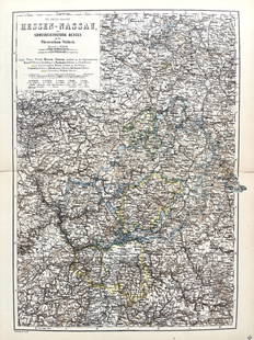
Sold2022Original Antique Map -Hessen Nassau - Map of Furstenthum WaldeckAntique outline hand colored map from edition of Meyer’s world atlas, edited by Ludwig Ravenstein, published by Bibliographic Institute in 1872. Technique: Engraving. Place: Leipzig, Germany. SSee Sold Price
Sold2022Antique Map Print - Map of Schleswig - Holstein - Map of Germany - LauenburgAntique outline hand colored map from edition of Meyer’s world atlas, edited by Ludwig Ravenstein, published by Bibliographic Institute in 1872. Technique: Engraving. Place: Leipzig, Germany. SSee Sold Price
Sold2022Antique Map Print - Map of Mecklenburg-Schwerin - Map of Germany - Roman EmpireAntique outline hand colored map from edition of Meyer’s world atlas, edited by Ludwig Ravenstein, published by Bibliographic Institute in 1872. Technique: Engraving. Place: Leipzig, Germany. SSee Sold Price
Sold2022Original Antique Map - Konicreich Bohmen - Map of Bohmen - Prague - CarlsbadAntique outline hand colored map from edition of Meyer’s world atlas, edited by Ludwig Ravenstein, published by Bibliographic Institute in 1872. Technique: Engraving. Place: Leipzig, Germany. SSee Sold Price
Sold2022Antique Map Print - Map of Rheinprovinz - Map of Germany - Prussian StateAntique outline hand colored map from edition of Meyer’s world atlas, edited by Ludwig Ravenstein, published by Bibliographic Institute in 1872. Technique: Engraving. Place: Leipzig, Germany. SSee Sold Price
Sold2022Antique Map Print - Map of Pomerania - Map of Germany - South of the Baltic SeaAntique outline hand colored map from edition of Meyer’s world atlas, edited by Ludwig Ravenstein, published by Bibliographic Institute in 1872. Technique: Engraving. Place: Leipzig, Germany. SSee Sold Price
Sold2022Antique Map Print - Map of Oldenburg - Map of Germany - Lower Saxony - HunteAntique outline hand colored map from edition of Meyer’s world atlas, edited by Ludwig Ravenstein, published by Bibliographic Institute in 1872. Technique: Engraving. Place: Leipzig, Germany. SSee Sold Price
BonhamsMITCHELL (SAMUEL AUGUSTUS) Mitchell's New General Atlas, Containing Maps of the Various Countrie...£500
BonhamsASHER AND ADAMS Asher & Adams' New Historical and Topographical Atlas of the United States. With...£300
BonhamsCHURCHILL (WINSTON S.) Photograph of Winston Churchill (as Secretary of State of War) seated wit...£1,800
1 day LeftActivity AuctionsRare 1976**Franklin Mint*Sterling Silver**925/Gold World Map Old Art PieceUS$1,100
4 days LeftWorthington Galleries19th c. Hemisphere World Map, Hohen und Tiefen der Erde in Lambert’s Zenithal-Projection vonUS$10
Jun 13Swann Auction Galleries(WORLD.) Group of 6 eighteenth-century engraved double-hemispheric world maps.US$900
3 days LeftRapid Estate Liquidators and Auction GalleryLaminated Unique Media The World Map 1996 EditionUS$15
7 days LeftJasper521817 3 VOYAGES of CAPTAIN COOK 6 vols ILLUSTRATED w/ WORLD MAP antique in FRENCHUS$1,000
Jun 15Fine Arts OutletYoung Couple Reviewing a World Map Bronze Statue - Size: 32"L x 47"W x 42"H.US$3,150


![[CIVIL WAR-MAPS] The New York Herald War Maps and Diagrams. New York: Edward Lloyd, n.d., circa: [CIVIL WAR-MAPS] The New York Herald War Maps and Diagrams. New York: Edward Lloyd, n.d., circa 1861. An unusual compilation of lithographed maps within a black border, appears to be four sheets joine](https://p1.liveauctioneers.com/292/250642/130213465_1_x.jpg?height=310&quality=70&version=1654271664)