Sold2023Antique 19th C. Map of East Los Angeles CountyAntique 19th Century panoramic map of East Los Angeles County, California, depicting a bird's-eye view from Los Angeles River looking towards the Sierra Madre Mountains. Printed by H.S. Crocker & Co.,See Sold Price
Sold202119TH C. MAP OF NEW YORK & BROOKLYN (TEAR)19TH C. MAP OF NEW YORK & BROOKLYN (TEAR) 25.5" X 40"See Sold Price
Sold2021(16) 19TH C. MAPS OF THE WEST INDIES IN FOLIO,Including: "L'Isle de Ste. Domingue, et celle de Porto Rico", by Bonne, hand colored engraving,1778, 10" x 14 1/2"; PLUS "West Indies", Smith's Atlas, 1808, hand colored engraving, 1808, 11" x 14"; PLSee Sold Price
Sold202319thC "Historical Map of Nantucket Surveyed and Drawn by The Rev. E.C. Ewer 1869" - overall framed19thC "Historical Map of Nantucket Surveyed and Drawn by The Rev. E.C. Ewer 1869" - overall framed size 10"x14"See Sold Price
Sold202419th C. Thomas Holme Province of Pennsylvania MapA 19th C. facsimile map of a 1681 issued map titled "A Map of the Improved Part of the Province of Pennsilvania in America". Includes a note from a Philadelphia print shop. Frame opening: 34in x 56-1/See Sold Price
Sold2023Six Antique Maps of America Engravings, 19th c., H.- 7 1/4 in., W.- 4 1/2 in., Framed- H.- 15 in.,Six Antique Maps of America Engravings, 19th c., includes: "Map 8 1776 / Framing Declaration," "Map 5 1692 / New France: Map of the Discoveries of Marquette, La Salle and Other Frenchmen," "Map No. 12See Sold Price
Sold2017Texas nach den Besten Quellen Map, 19th CMap: Texas nach den Besten Quellen Cartographer: Bibliographischen Instituts. / Radefeld Place & Date: Hildburghausen / 1849/1857 Size: 13 7/8" x 11 1/2" Condition: original outline color The scarce sSee Sold Price
Sold2020Japanese 6-Panel Screen Map, c. 19th CenturyA Japanese hand painted screen possibly depicting a map of bay regions in Japan. The piece is presented predominantly in shades of blue and brown with vibrant gilt detailing. The screen features six pSee Sold Price
Sold2021EARLY AMERICAN 3 DRAWER MAP CHEST, 19TH C.EARLY AMERICAN 3 DRAWER MAP CHEST HAVING GALLERY TOP RESTING ON TURNED FEET, 19TH C.;; 27.5"H X 31"W X 30"DSee Sold Price
Sold202019th C 42 Drawer Ok Map CabinetR sections, original hardware, 64 tall x 41 wide x 13 deep top, 17.5 deep baseSee Sold Price
Sold2021Schotte and Co. mini terrestrial globeSchotte and Co. mini terrestrial globe, Mid-19th c., France, hand-tinted map engraving over papier-mache, rotating on turned wood stand, signed in engraving "Globe Schotte de Berlin revu et corrige paSee Sold Price
Sold202370304: A Marshall Islands Navigation Map Micronesia, 1A Marshall Islands Navigation Map Micronesia, 19th century Constructed of coconut palm leaf midribs and shells. Such maps or charts were for navigating specific atolls and islands in MicrSee Sold Price
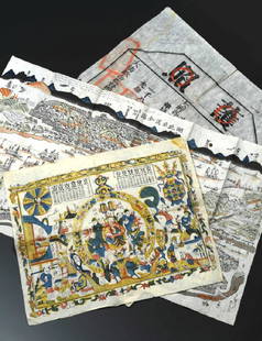
Sold2016Traditional Map with Inscription, Korea, 19th C.Ink and color on paper Korea, 19th century Zodiac with designations such as city, mountain and river names Presumably based on the Chinese work ‘classic of mountains and seas’ (Shanhaijing), the oSee Sold Price
Sold2022A. Dunsford, hand-drawn world map, 1859A. Dunsford, hand-drawn world map, 1859, A. Dunsford (19th c., likely American), ink, gouache and watercolor on paper, mounted on linen, dated "Xmas 1859" and marked "A. Dunsford - Wellington Academy"See Sold Price
Sold2024Anna Pottery Railroad and River Guide FlaskAmerican Second Half 19th Century. Pig Shaped with river and railroad map and inscribed "With a little good old rye in hogs.."See Sold Price
Sold2020Grp: 10 Maps of New York City 18th-Early 20th c.Group of 18th to early 20th century maps of New York City. Multiple are 19th-20th c. reprints of 17th-18th c. maps. Includes a small census map of New York City from 1850 with populations of New YorkSee Sold Price
Sold2022MAHOGANY FOLIO STAND19th c. Adjustable Rack, for documents, prints and maps, with hinged latticework adjustable wings, set on a trestle base with turned stretchers, 31 1/4" high, 25" x 21". Good condition. From the HayneSee Sold Price
Sold2022SET OF (2) HUNTINGTON CIRCUMPOLAR MAPS BY ELIJAH BURRITTLot of (2) Early 19th c. Hand Colored Northern and Southern Circumpolar Maps For Each Month of the Year, depicting the constellations of the northern and southern hemispheres, by cartographer Elijah BSee Sold Price
Sold2019China Missions, late 19th century, a small box ofChina Missions, late 19th century, a small box of various China Missionary items and ephemera, including a tissue paper map, passport to Rev. A W Nightingale expiring 1880, signed 'Bullock', printed sSee Sold Price
Sold2024Tasso Italian Map the United States 1832TASSO, G. (19th Century). Stati-Uniti dell' America Settentrionale dalle Piu Recenti Mappe... Engraved map with original hand color. Venice, 1832. 15 1/4" x 19 3/4" sheet. Scarce map from an Italian eSee Sold Price
Sold2017J. J. Stoner, Birds-eye map of Helena, MontanaJ. J. Stoner, Birds-eye map of Helena, Montana, J.J. Stoner (American, 19th c.), "Bird's Eye View of Helena, 1883", illustrated and with index of points of interest, hand-colored engraving, publishedSee Sold Price
Sold2017George E. Norris, birdseye map Tallapoosa GAGeorge E. Norris, birdseye map Tallapoosa GA, George E. Norris (American, 19th c.), "1892 Tallapoosa, GA. Haralson Co. Looking Northwest", hand-colored engraving, Kennedy Galleries label verso, 24"h xSee Sold Price
Sold2016OTTAVIO SCHEGGI (19TH C.) ALABASTER SCULPTURE NAPOLEONA carved sculpture of Napoleon Bonaparte on the battlefield in bicorn hat holding binoculars along with a rolled map, allegories of cannonry along his right side. Signed back side of the base. MeasureSee Sold Price
6 days LeftSchilb Antiquarian Rare Books1848 Emory Military Reconnaissance 1ed California MAP Indians Texas New MexicoUS$5(5 bids)
6 days LeftSchilb Antiquarian Rare Books1870 BEAUTIFUL Life of Jesus Christ Fleetwood Bible ART Miracles Jerusalem MapUS$150(7 bids)
1 day LeftJasper521760 MAP CARTE PARTICULIERE DE L'ISLE DE JUAN FERNANDES antique Robinson CrusoeUS$55(1 bid)
1 day LeftJasper521772 GREEK BIBLE NEW TESTAMENT antique BIBLIA LATIN text MAP NOVUM TESTAMENTUMUS$360
6 days LeftSchilb Antiquarian Rare Books1877 Geology Geography Surveys 1ed Nevada Wyoming Utah George Wheeler US West 2vUS$1(1 bid)
Featured1 day LeftJasper521749-59 21 volumes NETHERLANDS HISTORY ILLUSTRATED antique VELLUM BOUNDUS$1,400