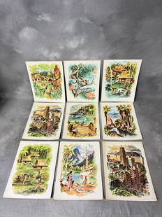
Sold20211888 Isles of Pacific Ocean New Zealand Fiji Tahiti1888 Isles of Pacific Ocean New Zealand Fiji Tahiti Easter Island Moai Hawaii “The Isles of the Pacific” is a late 19th-century history of the geography and wonders of the islands in the South PacSee Sold Price
Sold2021[Pacific Islands] Oceanic Steamship Co. Playing Cards.[Pacific Islands] Oceanic Steamship Co. Playing Cards. San Francisco, ca. 1920. 52 + J + EC + OB. Joker advertises the ocean liner’s service to Hawaii, Samoa, Tahiti, New Zealand, Australia, andSee Sold Price
Sold2023PACIFIC OCEAN. Australia New Zealand Polynesia Micronesia. BLACKIE 1893 mapTITLE/CONTENT OF MAP: 'The Pacific Ocean, general map' DATE PRINTED: 1893 IMAGE SIZE: Approx 35.0 x 51.5cm, 13.75 x 20.25 inches (Large); Please note that this is a folding map. TYPE: Colour Antique mSee Sold Price
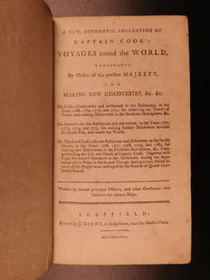
Sold20231797 Captain James Cook Pacific Voyages New Zealand Australia Tahiti Tasmania1797 Captain James Cook Pacific Voyages New Zealand Australia Tahiti Tasmania “Remember, the greater the opportunity, the fewer are those who see it.” – James Cook James Cook was anSee Sold Price
Sold2023PACIFIC OCEAN Sandwich Islands/Hawaii Australia New Zealand &c. WELLER 1863 mapTITLE/CONTENT OF MAP: 'The Pacific Ocean' DATE PRINTED: 1863 IMAGE SIZE: Approx 47.0 x 65.0cm, 18.5 x 25.75 inches (Large); Please note that this is a folding map. TYPE: Antique map with original outlSee Sold Price
Sold2017Weller: Map of Pacific, Hawaii Australia New ZealandTITLE/CONTENT OF MAP: 'The Pacific Ocean'. Sandwich Islands/Hawaii Australia New Zealand This map is folding hence the centrefold line may show on the image below DATE PRINTED: 1862 IMAGE SIZE: ApproxSee Sold Price
Sold2016Hawaiian & Pacific Polynesian Islands, Australia, 1850Original engraving by Samuel Augustus Mitchell from Mitchell’s Universal Atlas, 1850. Map highlights the Pacific ocean & surrounding islands; Hawaii, Polynesian, Australia & New Zealand. Dimensions:See Sold Price
Sold2022(16)1940s-60s Matson Lines Ship Menus - Hawaii, San Francisco, Fiji, Tahiti, Southern California,(16)1940s-60s Matson Lines Ship Menus - Hawaii, San Francisco, Fiji, Tahiti, Southern California, Samoa, New Zealand, Australia - by Louis MacouillardSee Sold Price
Sold2019Three Maps by the Hydrographic Office U. S. Navy,Three Maps by the Hydrographic Office U. S. Navy, consisting of "South Pacific Ocean, New Caledonia, New Caledonia Isle of Pines to Ven Island," 1921, H. - 42 in., W. -29 in.; with "South Pacific OceaSee Sold Price
Sold2018Pacific OceanTitle/Content of Map: Pacific Ocean Date Printed: 1840-05-15 Cartographer: WALKER, J. & C. Size: 12.2X15.5 Details from the Aleutian Island to Australia/New Zealand and to Cape Horn/South America. DetSee Sold Price
Sold2018Reclus, Elisee C1880 Lot of 28 Wood Eng Maps, GoodIncl Australia, Tasmania, New Zealand, Philippines, Reunion, Madeira, Madagascar, Indian & Pacific Ocean. Wood Engraved Maps with surrounding and verso text. Published 1875-94, Paris for "La NouvelleSee Sold Price
Sold2018POLYNESIA/PACIFIC ISLANDS. inc Sandwich/HawaiianTITLE/CONTENT OF MAP: 'Polynesia or Islands in the Pacific Ocean' Vignettes: Resolution Bay, Marquesas; Harbour of Dory, New Guinea; Otaheite [Tahiti]; Kalakakooa, Sandwich Islands [Hawaiian islands].See Sold Price
Sold2023POLYNESIA/PACIFIC ISLANDS. inc Sandwich/Hawaiian islands. RAPKIN/TALLIS 1851 mapCAPTION PRINTED BELOW PICTURE: 'Polynesia or Islands in the Pacific Ocean' Vignettes: Resolution Bay, Marquesas; Harbour of Dory, New Guinea; Otaheite [Tahiti]; Kalakakooa, Sandwich Islands [HawaiianSee Sold Price
2018POLYNESIA/PACIFIC ISLANDS. inc Sandwich/HawaiianReserve Reduced! TITLE/CONTENT OF MAP: 'Polynesia or Islands in the Pacific Ocean' Vignettes: Resolution Bay, Marquesas; Harbour of Dory, New Guinea; Otaheite [Tahiti]; Kalakakooa, Sandwich Islands [HSee Sold Price
Sold20191786 VERY RARE Voyages of Captain James Cook Hawaii1786 VERY RARE Voyages of Captain James Cook Hawaii Pacific Australia New Zealand “Remember, the greater the opportunity, the fewer are those who see it.” – James Cook James Cook was an 18th-cenSee Sold Price
20201794 Voyages of Captain James Cook Australia1794 Voyages of Captain James Cook Australia New Zealand Hawaii Pacific Berenger “Remember, the greater the opportunity, the fewer are those who see it.” – James Cook James Cook was an 18th-centSee Sold Price
Sold202220th C. Polynesian Tokelau Wood Fishing Box / TulumaSouth Pacific, Polynesia, Tokelau Island (New Zealand territory), ca. early to mid-20th century CE. A hand-carved wooden container known as a tuluma, with a lid and sennit (coconut) fiber cord. The tuSee Sold Price
Sold2016Reinecke: Australia/ New Zealand/ Hawaii Map 1804Map: Australia/ New Zealand/ Hawaii/ South Pacific "General Charte von Australien" Publishing: Reinecke, Johann Matthias: Weimar Date: 1804 Size: 17.75 x 24 inches An uncommon map described by TooleySee Sold Price
Sold20161848 MAP OF THE UNITED STATES AND MEXICOPortraits of Washington, Gen. Taylor and Gen Scott", 'Panoramic View from New York to the Pacific Ocean by the Contemplated Oregon Railroad. Brief entries for the States and Territories of the UnitedSee Sold Price
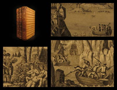
Sold2017Buller Second Ed. History of the Birds of New ZealandA History of the Birds of New Zealand. Sir Walter Lawry Buller (1838-1906). London: published by the author, [1887] - 1888. Guidance: Christie's, 2013, 6,000 EUR. 2 volumes. Folio (14 6/8 x 11 inches)See Sold Price
Sold2023Buller's History New Zealand Birds w/ sup. vols.Heading: Author: Buller, Walter Lawry Title: A History of the Birds of New Zealand Place Published: London Publisher:Published (for the subscribers) by the Author Date Published: 1888-1905See Sold Price
Sold2020J. M. MaddenJ. M. Madden New Zealand Lake Scene ink and wash and bodycolour on paper signed and dated 1888 220 x 295mmSee Sold Price
Sold2022Currier & Ives - Through to the PacificCURRIER, Nathaniel (1813-1888) & IVES, James (1824-1895). Through to the Pacific. Lithograph with original hand color. New York, Currier & Ives, 1870. 9 1/4" x 13 1/4" sheet, 19" x 22 3/4" framed. GalSee Sold Price
Sold2024Joseph Yoakum. Junction Point of South Atlantic Ocean and South Pacific Ocean.Joseph Yoakum. (1891-1972). The Junction Point of South Atlantic Ocean and South Pacific Ocean Near Delfulgo, Argentina and Pairgona. Signed and titled. Ink, colored pencil and graphite on paper. MastSee Sold Price
Jun 23Schilb Antiquarian Rare Books1786 Voyages James Cook New Zealand Tahiti Palestine Palmyra Temple SYRIA 4vUS$1(1 bid)
1 day LeftJasper52Orient. Western Pacific Islands. Fiji Tonga Melanesia Micronesia. TIMES 1958 mapUS$30
5 days LeftPacific Global Auction1967 New Zealand Dollar Elizabeth II BU (Decimalization Commem)US$21
3 days LeftPacific Global Auction1 oz New Zealand Silver $2 Niue Hawksbill Turtle Coin (Random Year)US$40
4 days LeftPacific Global Auction2022 1 oz Proof Niue Colorized Silver Disney Bambi and Flower CoinUS$115
Jun 02Schilb Antiquarian Rare Books1880 Captain James Cook Voyages Hawaii Pacific Australia Kippis South Sea NavyUS$50(3 bids)
Jun 07Freeman's | HindmanROSENTHAL, Joe. Flag Raising on Mt. Suribachi, Iwo Jima. -- Aerial View of a Pacific Island. -- TheUS$1,000
Jun 08Leon GalleryVincenzo Maria Coronelli (1650-1718) - Asia Divisa Nelle sue Parti Secondo lo Stato Presente₱220,000
Featured1 day LeftJasper52Suite de l’Ocean Oriental…' East Asia/Indies. Western Pacific. BELLIN 1746 mapUS$200
Jun 06Austin Auction GalleryMICHAEL WAYSMITH (NEW ZEALAND, 20TH C) STUDIO ART GLASS MURRINE VASEUS$325(3 bids)
22 hrs LeftConcept Art Gallery2 Zane Grey Fishing Tales 1st Editions New Zealand and Fresh-WaterUS$175(3 bids)
Jun 06Austin Auction GalleryMICHAEL WAYSMITH (NEW ZEALAND, 20TH C) STUDIO ART GLASS MURRINE VASEUS$150(3 bids)
Jun 06Austin Auction GalleryMICHAEL WAYSMITH (NEW ZEALAND, 20TH C) STUDIO ART GLASS MURRINE VASEUS$125(2 bids)


![[Pacific Islands] Oceanic Steamship Co. Playing Cards.: [Pacific Islands] Oceanic Steamship Co. Playing Cards. San Francisco, ca. 1920. 52 + J + EC + OB. Joker advertises the ocean liner’s service to Hawaii, Samoa, Tahiti, New Zealand, Australia, and](https://p1.liveauctioneers.com/928/188932/95239653_1_x.jpg?height=310&quality=70&version=1609352044)


![POLYNESIA/PACIFIC ISLANDS. inc Sandwich/Hawaiian: TITLE/CONTENT OF MAP: 'Polynesia or Islands in the Pacific Ocean' Vignettes: Resolution Bay, Marquesas; Harbour of Dory, New Guinea; Otaheite [Tahiti]; Kalakakooa, Sandwich Islands [Hawaiian islands].](https://p1.liveauctioneers.com/5584/128489/65352606_1_x.jpg?height=310&quality=70&version=1538523113)
![POLYNESIA/PACIFIC ISLANDS. inc Sandwich/Hawaiian islands. RAPKIN/TALLIS 1851 map: CAPTION PRINTED BELOW PICTURE: 'Polynesia or Islands in the Pacific Ocean' Vignettes: Resolution Bay, Marquesas; Harbour of Dory, New Guinea; Otaheite [Tahiti]; Kalakakooa, Sandwich Islands [Hawaiian](https://p1.liveauctioneers.com/5584/298779/159029476_1_x.jpg?height=310&quality=70&version=1692132475)
![POLYNESIA/PACIFIC ISLANDS. inc Sandwich/Hawaiian: Reserve Reduced! TITLE/CONTENT OF MAP: 'Polynesia or Islands in the Pacific Ocean' Vignettes: Resolution Bay, Marquesas; Harbour of Dory, New Guinea; Otaheite [Tahiti]; Kalakakooa, Sandwich Islands [H](https://p1.liveauctioneers.com/5584/129679/65959649_1_x.jpg?height=310&quality=70&version=1540338370)


![Buller Second Ed. History of the Birds of New Zealand: A History of the Birds of New Zealand. Sir Walter Lawry Buller (1838-1906). London: published by the author, [1887] - 1888. Guidance: Christie's, 2013, 6,000 EUR. 2 volumes. Folio (14 6/8 x 11 inches)](https://p1.liveauctioneers.com/1968/103428/52944524_1_x.jpg?height=310&quality=70&version=1493741966)


![1892 Black Map of New Zealand and [on Separate Sheet] Pacific Ocean (1 of 2)](https://p1.liveauctioneers.com/5584/329422/177662236_1_x.jpg?height=282&quality=70&version=1715717898)


