Sold2017Weller: Map of Pacific, Hawaii Australia New ZealandTITLE/CONTENT OF MAP: 'The Pacific Ocean'. Sandwich Islands/Hawaii Australia New Zealand This map is folding hence the centrefold line may show on the image below DATE PRINTED: 1862 IMAGE SIZE: ApproxSee Sold Price
Sold2017Brockhaus: Antique Map of South Pacific, 1885Title/Content of Map: 1885 Brockhaus Map of South Pacific including Hawaii, Australia and New Zealand -- Ocenaien und Australisches Festland Date Printed: 1885, Leipzig Cartographer: F Brockhaus Size:See Sold Price
Sold2016Hawaiian & Pacific Polynesian Islands, Australia, 1850Original engraving by Samuel Augustus Mitchell from Mitchell’s Universal Atlas, 1850. Map highlights the Pacific ocean & surrounding islands; Hawaii, Polynesian, Australia & New Zealand. Dimensions:See Sold Price
Sold2016Reinecke: Australia/ New Zealand/ Hawaii Map 1804Map: Australia/ New Zealand/ Hawaii/ South Pacific "General Charte von Australien" Publishing: Reinecke, Johann Matthias: Weimar Date: 1804 Size: 17.75 x 24 inches An uncommon map described by TooleySee Sold Price
Sold2023PACIFIC OCEAN Sandwich Islands/Hawaii Australia New Zealand &c. WELLER 1863 mapTITLE/CONTENT OF MAP: 'The Pacific Ocean' DATE PRINTED: 1863 IMAGE SIZE: Approx 47.0 x 65.0cm, 18.5 x 25.75 inches (Large); Please note that this is a folding map. TYPE: Antique map with original outlSee Sold Price
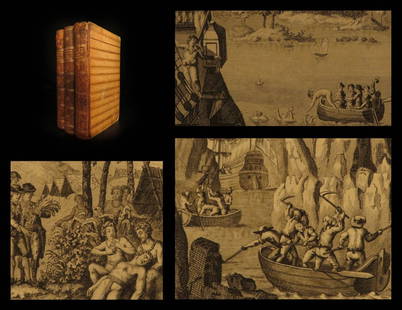
Sold20191786 VERY RARE Voyages of Captain James Cook Hawaii1786 VERY RARE Voyages of Captain James Cook Hawaii Pacific Australia New Zealand “Remember, the greater the opportunity, the fewer are those who see it.” – James Cook James Cook was an 18th-cenSee Sold Price
20201794 Voyages of Captain James Cook Australia1794 Voyages of Captain James Cook Australia New Zealand Hawaii Pacific Berenger “Remember, the greater the opportunity, the fewer are those who see it.” – James Cook James Cook was an 18th-centSee Sold Price
Sold20181796 Voyages of Captain James Cook Australia New Zealan1796 Voyages of Captain James Cook Australia New Zealand Hawaii Pacific Berenger “Remember, the greater the opportunity, the fewer are those who see it.” – James Cook James Cook was an 18th-centSee Sold Price
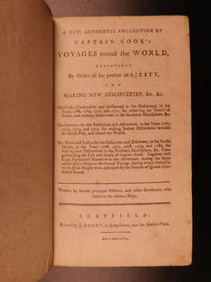
Sold20211893 Captain Cook Voyages Australia New Zealand Hawaii1893 Captain Cook Voyages Australia New Zealand Hawaii Pacific Illustrated “Remember, the greater the opportunity, the fewer are those who see it.” – James Cook James Cook was an 18th-century BrSee Sold Price
Sold20181893 Captain Cook Voyages Australia New Zealand Hawaii1893 Captain Cook Voyages Australia New Zealand Hawaii Pacific Illustrated “Remember, the greater the opportunity, the fewer are those who see it.” – James Cook James Cook was an 18th-century BrSee Sold Price
Sold2021Australien und Polynesien (Australia & Polynesia)Title: Australien und Polynesien (Australia & Polynesia) Publisher: Haack Height: 62 Width: 82 Handsome and enormous display map of the South Pacific from All of Australia, New Zealand through most ofSee Sold Price
Sold2018Pacific OceanTitle/Content of Map: Pacific Ocean Date Printed: 1840-05-15 Cartographer: WALKER, J. & C. Size: 12.2X15.5 Details from the Aleutian Island to Australia/New Zealand and to Cape Horn/South America. DetSee Sold Price
Sold2023PACIFIC OCEAN. Australia New Zealand Polynesia Micronesia. BLACKIE 1893 mapTITLE/CONTENT OF MAP: 'The Pacific Ocean, general map' DATE PRINTED: 1893 IMAGE SIZE: Approx 35.0 x 51.5cm, 13.75 x 20.25 inches (Large); Please note that this is a folding map. TYPE: Colour Antique mSee Sold Price
Sold2019Johnston, W. & A. K. 1903 Lot of 28 MapsLot of 28 Lithograph Maps, incl Twin Hemisphere, Europe, Argentina, Canada, New Guinea, New Zealand, Australia, Pacific, Abyssinia, Egypt, Rhodesia, Central Africa, Algeria, Africa, Tibet, Japan, RussSee Sold Price
Sold2019Johnston, W. & A. K. 1903 Lot of 28 MapsLot of 28 Lithograph Maps, incl Twin Hemisphere, Europe, Argentina, Canada, New Guinea, New Zealand, Australia, Pacific, Abyssinia, Egypt, Rhodesia, Central Africa, Algeria, Africa, Tibet, Japan, RussSee Sold Price
Sold2018Reclus, Elisee C1880 Lot of 28 Wood Eng Maps, GoodIncl Australia, Tasmania, New Zealand, Philippines, Reunion, Madeira, Madagascar, Indian & Pacific Ocean. Wood Engraved Maps with surrounding and verso text. Published 1875-94, Paris for "La NouvelleSee Sold Price
Sold2021[Pacific Islands] Oceanic Steamship Co. Playing Cards.[Pacific Islands] Oceanic Steamship Co. Playing Cards. San Francisco, ca. 1920. 52 + J + EC + OB. Joker advertises the ocean liner’s service to Hawaii, Samoa, Tahiti, New Zealand, Australia, andSee Sold Price
Sold2018Indian Ocean Map 1941Indian Ocean Map : Australia, New Zealand and Malaysia. National Geographic magazine. Date: 1941. Editor: Gilbert Grosvenor. Measurement approximate: 25 x 32. Shipping cost: $15.00 excluding Hawaii, ASee Sold Price
Sold2020Bartholomew, John 1922 Pair Maps. New Zealand & Pacific"New Zealand" and "Islands of Oceania" The latter showing Hawaii and other Pacific Islands. Large Lithograph Maps Published 1922 by The Times, London for "The Times Survey Atlas of the World" Maps bySee Sold Price
Sold2018Weller, F. S. C1890 Lot of 12 Antique MapsIncl German Empire, Switzerland, Holland/Belgium, Austria/Hungria, Russia, Asia, Africa, Sweden/Norway & Denmark, France, Australasia, Eastern Australia and New Zealand, and The World. Lot of 12 LithoSee Sold Price
Sold2022Times Atlas 1895 Pair of Maps. Australia & New ZealandLithograph Map Published 1895, London for "The Times Atlas" Centre fold as published. Paper Size: Up to 21 x 16 inch (53 x 41cm) Centre fold split on once, Otherwise fineSee Sold Price
Sold2022Nat. Encyclo. C1875 Pair Maps. Australia & New ZealandLithograph Map Published C1868-81 by William Mackenzie, London for "The National Encyclopedia: A dictionary of Universal Knowledge" Centre Fold as issued. Paper Size: 12 x 9.5 inch (31 x 24cm) Good CoSee Sold Price
Sold2019Butler, George 1874 Pair of Maps. Australia New ZealandLithograph Maps Published 1874, London for "The Public School Atlas of Modern Geography" by Rev. George Butler. Paper Size: 11 x 7 inch (28 x 17cm) Good ConditionSee Sold Price
Sold2018Colton: Antique Map of Hawaii, New Zealand, 1859Title/Content of Map: Hawaii, New Zealand & other islands Date Printed: 1859 Cartographer: H.J. Colton Material/Medium: Paper Size: 17 1/2" x 15" Hand colored engraved Map. Publsihed in New York in 'CSee Sold Price
May 17Albion AuctionsStieler, Adolf 1909 Antique Map. New Zealand - South Sea Islands, Pacific Australia HawaiiUS$5
2 days LeftTrillium Antique Prints & Rare BooksPrevost - Map of the South Pacific Ocean with New Holland (Australia), New Zealand, and part of theUS$50(1 bid)
Jun 02Schilb Antiquarian Rare Books1880 Captain James Cook Voyages Hawaii Pacific Australia Kippis South Sea NavyUS$1(1 bid)
May 17Albion AuctionsCooke, George 1801 Antique Map. Pacific Ocean - Australia etc (Fault)US$5(1 bid)
5 days LeftAkiba Galleries(2 Pc) Allain Manesson Mallet Description De L'Univers 2 Vol. German TranslationUS$200(1 bid)


![[Pacific Islands] Oceanic Steamship Co. Playing Cards.: [Pacific Islands] Oceanic Steamship Co. Playing Cards. San Francisco, ca. 1920. 52 + J + EC + OB. Joker advertises the ocean liner’s service to Hawaii, Samoa, Tahiti, New Zealand, Australia, and](https://p1.liveauctioneers.com/928/188932/95239653_1_x.jpg?height=310&quality=70&version=1609352044)


