Sold20211842 Map of FranceAuthor: Scott Title: 1842 Map of France Medium: Ink on Paper Dimensions: 11.5"X9" Map of France engraved by R. Scott dated 1842. Part of the New General Atlas of the World. Published by Thomas NelsonSee Sold Price
Sold2022Butler, Samuel 1842 Pair of Maps of FranceSteel Engraved Map Published 1842, London for "An Atlas of Modern Geography" by Samuel Butler. Drawn & Engraved by Sidney Hall. Centre fold as published. Original outline hand colour. Paper Size: 10.5See Sold Price
Sold2016[Wall map] FranceCarte de la France, 1790.Incisione in coloritura coeva, 1200x1160 mm.See Sold Price
Sold2021Jean Jolivet Map, FranceGalliae Regni Potentiss", hand colored engraving by Jean Olivet, with text verso. Toning, spotting, tears, pencil marks at the lower right, other wear. 18.5" x 23See Sold Price
Sold2024West India Islands. Caribbean. La Salle settlement in Texas. LIZARS 1842 mapTITLE/CONTENT OF MAP: 'West India Islands and adjacent coasts of the United States, Mexico, Guatimala & Colombia' The map notes anecdotally the location of René Robert Cavelier, Sieur de La SalleSee Sold Price
Sold2023South America /Atlantic Ocean. Gran Colombia. United Provinces. LIZARS 1842 mapTitle: South America /Atlantic Ocean. Gran Colombia. United Provinces. LIZARS 1842 map Description: South America' by William Home Lizars (1842). Antique 19th century atlas map with original hand coloSee Sold Price
Sold2024Antique Europe Map/ France. Pieced down in sections. Sight size 26-1/2 x 36 inches. Overall framedAntique Europe Map/ France. Pieced down in sections. Sight size 26-1/2 x 36 inches. Overall framed size is 32 x 42 inchesSee Sold Price
Sold2019Gallia Color Map [France]Galliae Regni Potentiss Color Map with written description in Latin on verso. Map of France with boarders to Germany, Spain and Italy. Appears to be a page from an atlas. Undated. Measures 14 in. x 20See Sold Price
Sold20201842 map of New York City, Sidney MorseFrom the very first cerographic atlas ever published. Two tiny very lightly discolored areas at top edge; corner crease. 12 x 15. Reserve: $90.00 Shipping: Domestic: Flat-rate of $6.00 to anywhere witSee Sold Price
Sold2024MAP, France, ValckNorthwestern France. Valck, Normannia Ducatus, tum Superior ad Ortum, tum Inferior ad Occasum, Praefectura Generalis; in qua Distinctissime Exhibentur ejus Archiepiscopatus Rothomagensis..., 1700 (cirSee Sold Price
Sold2024MAP, France, HomannWestern France. Johann Baptist Homann, Tabula Ducatus Britanniae Gallis le Gouvernemt. General de Bretagne in suos Novem Episcopatus..., 1720 (circa). Hand Color. Large and very detailed chart roughlySee Sold Price
Sold2016Antique Map : France - 1802Antique Map : France - 1802 from Walker's Geography Gazette. Size : 10.25" x 8.25"See Sold Price
Sold20201842 Map of North AmericaAuthor: Scott Title: 1842 Map of North America Medium: Ink on Paper Dimensions: 9"X11.5" Map of North America dated 1842. Engraved by R. Scott. Part of the New General Atlas of the World. Published bySee Sold Price
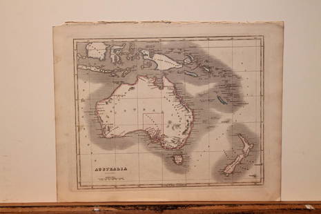
20201842 Map of AustraliaAuthor: Scott Title: 1842 Map of Australia Medium: Ink on Paper Dimensions: 11.5X9" Description: Map of Australia dated 1842. Copper plate map. Engraved by R. Scott. Published by Thomas Nelson in EdinSee Sold Price
Sold2023MAP, France, AaLyon, France. Pieter van der Aa, Lyon, Capitale du Lyonnois, 1710 (circa). Black & White. This rare and beautifully engraved view of Lyon is surrounded by an ornate architectural border, which was priSee Sold Price
Sold20201842 Map of AsiaAuthor: Scott Title: 1842 Map of Asia Medium: Ink on Paper Dimensions: 11.5"X 9" Description: Map of Asia dated 1842. Copper plate map. Engraved by R. Scott. Published by Thomas Nelson in Edinburgh. PSee Sold Price
Sold20201842 Map of AustraliaAuthor: Scott Title: 1842 Map of Australia Medium: Ink on Paper Dimensions: 11.5"X9" Map of Australia dated 1842. Copper plate map. Engraved by R. Scott. Published by Thomas Nelson in Edinburgh. PartSee Sold Price
Sold2016Engraving, Map "France in Departments"Published by John Thomson & Edinburgh. 9 1/2"h x 11 1/2"wSee Sold Price
Sold2020ANTIQUE MAP FRANCE SUTTON NICHOLLSFine antique map of British Isles by Sutton Nicholls 18th/19th century. Measuring framed 22 x 26 inches wide sight view 15 x 20 inches. Good condition. Printed on laid paper.See Sold Price
Sold20201842 Map of AfricaAuthor: Scott Title: 1842 Map of Africa Medium: Ink on Paper Dimensions: 11.5 X 9" Description: Map of Africa dated 1842. Copper plate map. Engraved by R. Scott. Published by Thomas Nelson in EdinburgSee Sold Price
Sold2018Early Map France Spain and PortugalC. 1850 by S. Augustus Mitchell Jr. in the Clerk's Office of the District Court of the U.S. for the Eastern District of Pa. Framed. 14" x 11"See Sold Price
Sold20201842 Map of North AmericaTitle: 1842 Map of North America Author: Nelson Medium: Ink on Paper Dimensions: 9"X11.5" Description: Map of North America dated 1842. Engraved by R. Scott. Part of the New General Atlas of the WorldSee Sold Price
Sold20201842 Map of ChinaAuthor: Scott Title: 1842 Map of China Medium: Ink on Paper Dimensions: 9"X11.5" Description: Map of China dated 1842. Copper plate map. Engraved by R. Scott. Published by Thomas Nelson in Edinburgh.See Sold Price
Sold20211842 Map of GreeceAuthor: Scott Title: 1842 Map of Greece Medium: Ink on Paper Dimensions: 11.5"X9" Map of Greece dated 1842. Engraved by R. Scott. Part of the New General Atlas of the World. Copper plate engraving. PuSee Sold Price
Jun 23East Coast Fine Arts LLC1777 US Revolutionary War Map French Brion de la Tour Theatre de GuerreUS$1,000
3 days LeftHolabird Western Americana CollectionsFrench Map of America Southwest & Mexico [179298]US$170
7 days LeftJasper521719 Senex Map of France -- A New Map of France, Showing the Roads & Post Stages Throout ThatUS$70
3 days LeftHolabird Western Americana CollectionsEarly French Map of East Coast & Canada [179301]US$200
Jun 16Broward Auction GalleryPaul Joseph Leyendecker (France,1842-1891) oil painting antiqueUS$100(2 bids)
4 days LeftWorthington GalleriesAntique H/C Map EUROPE SOUS CHARLEMAGNE EN 814: EMPIRES D'OCCIDENT ET D'ORIENTUS$25
22 hrs LeftJasper52L'Afrique Françoise ou du Senegal'. French West Africa. DE L’ISLE 1727 mapUS$100
6 days LeftWinter Associates Three historical engraved maps of the Caribbean, ranging from 1616-1814, each hand colored, framedUS$100(1 bid)


![[Wall map] France: Carte de la France, 1790.Incisione in coloritura coeva, 1200x1160 mm.](https://p1.liveauctioneers.com/3336/90951/46934974_1_x.jpg?height=310&quality=70&version=1473763184)


![Gallia Color Map [France]: Galliae Regni Potentiss Color Map with written description in Latin on verso. Map of France with boarders to Germany, Spain and Italy. Appears to be a page from an atlas. Undated. Measures 14 in. x 20](https://p1.liveauctioneers.com/5755/154409/77936853_1_x.jpg?height=310&quality=70&version=1573094011)


![French Map of America Southeast [179304] (1 of 1)](https://p1.liveauctioneers.com/2699/331495/178785746_1_x.jpg?height=282&quality=70&version=1717094933)
![Early French Map of Great Lakes [179300] (1 of 1)](https://p1.liveauctioneers.com/2699/331495/178785744_1_x.jpg?height=282&quality=70&version=1717094933)

![French Map of America Southwest & Mexico [179298] (1 of 1)](https://p1.liveauctioneers.com/2699/331495/178785763_1_x.jpg?height=282&quality=70&version=1717094933)


![Early French Map of East Coast & Canada [179301] (1 of 1)](https://p1.liveauctioneers.com/2699/331495/178785745_1_x.jpg?height=282&quality=70&version=1717094933)


