Sold20164 Anyique Framed MapsLot includes 4 gold framed antique maps, in order 1 map is marked on bottom Series M2 Hoffmann-Laroche Inc. Nutley 10, NJ and Totled at the top in the map Geographia Sacra emphasis on land continents,See Sold Price
Sold20164 Anyique Framed MapsLot includes 4 gold framed antique maps, in order 1 map is marked on bottom Series M2 Hoffmann-Laroche Inc. Nutley 10, NJ and Totled at the top in the map Geographia Sacra emphasis on land continents,See Sold Price
Sold2023ANTIQUE FLORIDA FRAMED MAPS - LOT OF 2148268 ANTIQUE FLORIDA FRAMED MAPS - LOT OF 2 Antique Florida map framed map to include one 1853 U.S. Coast Survey Chart or Map of St. George's Sound, Florida, and one unsigned map of Florida denotedSee Sold Price
Sold2020LOT OF THREE ANTIQUE c.1819 FRAMED MAPSLOT OF THREE ANTIQUE c.1819 FRAMED MAPS - EAST INDIES, DENMARK, SWEDEN, & NORWAY Height: 16 1/2 & 8 in. by Width: 18 1/2 & 10 in.See Sold Price
Sold2020(2 Pc) Framed Antique Celestial Map EngravingsDESCRIPTION: A lot of two antique celestial copperplate engravings from the series Harmonia Macrocosmica by Andreas Cellarius. The first "Sitvus Circvlis Cirvn Terra Coelestibvs Data" Engraved by JohaSee Sold Price
Sold2023Antique Framed Map of "Pars Scotiae Australi's"Description: This lot includes what appear to be an antique map titled "Pars Scotiae Australi's". The map is not dated however it appears to have age to it. See photos for details. Condition: ExpectedSee Sold Price
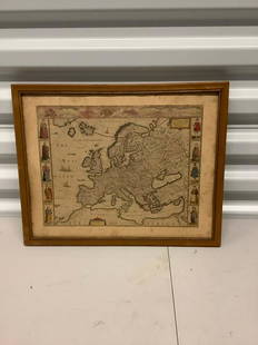
Sold2021Antique Framed Map of Europe, Europa Guilielmo BlaeuwAntique Color Map of Europe, Dutch Cartography. "Europa Recens Descripta" by Guilielmo Blaeuw, a cartographer for the Dutch East India Company. Lots of colorful detail of different nationalitiSee Sold Price
Sold2022Framed Needlepoint Old World Map Antique needlepoint of the world featuring the oceans and nauticalAntique needlepoint of the world featuring the oceans and nautical references.Framed 20.5" x 20"STERLING ASSOCIATES STRIVES TO PROVIDE ACCURATE, OBJECTIVE, & FAIR INFORMATION ON ALL LOTS. WE WILL BE HSee Sold Price
Sold2017Antique Framed Copper-Plate Engraving of Dutch BrazilThis lot consists of an antique engraving of a map of Dutch Brazil shows Povo and Olinda with numerous Dutch sailing ships in the attack on the Portuguese Olinda in 1630. Throughout most of the 17th cSee Sold Price
Sold2017Antique European Map Alsatia, 15th CenturyAntique European Map Alsatia. Hand colored accents 15th century map Latin descriptions. Ca 30x24 inches framed dimensions.Frame included with purchase. Please note that this lot has a confidential resSee Sold Price
Sold2023MAPS CARTOGRAPHY ITEMS WITH 2 HAND DRAWINGSThe lot includes a framed mid century American map Penobscot Bay And Approaches, United States - East Coast - Maine, Scale 1:80 000; Raritan River From Raritan Bay to New Brunswick New Jersey, Scale 2See Sold Price
Sold2024Antique Hawaiian Islands Government Survey Maps (Set of 6)Lot of 6 antique Hawaiian governmental survey maps (Hawaii, Lanai, Kaho'olawe, Maui, Moloka'I, Oahu, and the full island chain), signed by W.A.Wall. Framed w/ glass and single matted. (14"H 11.5"W 1"DSee Sold Price
Sold2020(3 Pc) Framed Vintage MapsDESCRIPTION: A lot of three vintage maps depicts Asia, Africa and the Mediterranean. Provenance: Purchased from Neville Sargent Gallery CIRCA: Early - Mid 20th Cent. DIMENSIONS: H: 15" W: 18" CONDITIOSee Sold Price
Sold20222 PC. FRAMED ANTIQUE MAPS OF ISRAEL2 PC. FRAMED ANTIQUE MAPS OF ISRAEL: Comprising; 1- Detailed Ortelius Map of the Holy Land, Based on Tilemann Stella's Extremely Rare Holy Land Maps. 1- Homann based this map of the Holy Land on the cSee Sold Price
Sold20182 Framed antique maps2 Framed antique maps, probably from an old atlas, British America & The United States, map drawn & engraved by J. Rapkin, illustrations by H. Warren & illustrations by R. Wallis, Maps are 10" x 13",See Sold Price
Sold2023Group of 4 Framed Antique MapsLargest overall is 24" x 21 1/2" Condition, some scratches and scuffs and missing paint to frames, some waves and creases to mapsSee Sold Price
Sold2021Lot Antique Maps Westchester CountyLot of Antique Maps of Westchester County. Includes 9 maps made in 19th century. Largest map measures 22.25 inches in height by 32.5 inches in width. This sale is online only - no public preview or liSee Sold Price
Sold2020Lot Antique Maps Of Connecticut State & TownsLot of Antique Maps Of Connecticut State & Towns. Includes 10 maps from 19th century. Largest map measures 23 inches in height by 20 inches in width.See Sold Price
Sold2020Framed Antique Map Orbis Vetus, Robert De VaugondyItem/Description: Old print. Map of the world by Robert de Vaugondy from 1752. Orbis vetus in utraque continente : In both the old continent / world map / Vaugondy 1752. Material: Print framed under gSee Sold Price
Sold2021Framed Antique Map of Northwest Germany, DeutschlandFramed Antique Map of Northwest Germany. Nicely framed in dark wood with an interior gold border and off-white mat. Tag on the back, which is wood-covered, shows the location of the map within DeutschSee Sold Price
Sold2020FRAMED ANTIQUE MAP OF THE WORLDFRAMED ANTIQUE MAP OF THE WORLD, ROBERT DE VAUGONDY, ORBIS VET US, 1752, GEOGRAPHO REGIS ORDINARIO. PAPER IS ACID BURNED AND FOLDED IN THE CENTER. Height: 27 & 19 1/2 in. by Width: 36 1/2 & 29 in.See Sold Price
Sold2023"Orbis Romani Pars Occidentalis" Framed Antique Map by Charles Smith c1820s"Orbis Romani Pars Occidentalis" Framed Antique Map by Charles Smith c1820s.See Sold Price
458 Lots AwayRapid Estate Liquidators and Auction GalleryAntique Framed Medieval Period Music Sheet On Animal ParchmentUS$400
471 Lots AwayBright Star Antiques Co.3pc. Lot of Framed Owl Prints 51 3/4"H x 38"L / 50"H x 36 1/2"LUS$25(1 bid)
20 hrs LeftBright Star Antiques Co.2pc. Lot of Framed Floral Paintings 14 1/4"H x 17 3/4"LUS$50(2 bids)
20 hrs LeftBright Star Antiques Co.4pc. Lot of Architectural Framed Mirrors 115 1/2"(9 ft. 7 1/2 in.) x 13" eachUS$25(1 bid)
May 13Flying Pig AuctionsLot of 2 framed items incl Primitives By Kathy print of an eagle by Pamela Hults & an antiqueUS$25