Sold2021Lochhead (Pub) 1811 Rare Map. England and WalesCopper Engraved Map Published 1811 by William Lochhead, Berwick for "Modern Geography: And a Compendious General Gazetteer" Rare. Folds as issued. Paper Size: 10.5 x 9.5 inch (27 x 24cm) Very minor toSee Sold Price
Sold2021Lochhead (Pub) 1811 Rare Map. Mexico, West Indies, USA"New Mexico New Spain with the West Indies" Showing Unmapped Southern States around the Guld of Mexico, New Mexico, Mexico, New Spain, Cuba, Haiti and The West Indies. Copper Engraved Map Published 18See Sold Price
Sold2021Lochhead (Pub) 1811 Rare Map. AfricaCopper Engraved Map Published 1811 by William Lochhead, Berwick for "Modern Geography: And a Compendious General Gazetteer" Rare. Folds as issued. Paper Size: 12 x 10 inch (30 x 26cm) Very minor toninSee Sold Price
Sold2021Lochhead (Pub) 1811 Rare Map. World HemisphereCopper Engraved Map Published 1811 by William Lochhead, Berwick for "Modern Geography: And a Compendious General Gazetteer" Rare. Folds as issued. Paper Size: 17 x 11 inch (43 x 28cm) Some creasing. VSee Sold Price
Sold2021Lochhead (Pub) 1811 Rare Map. Russia in Europe"The Southern Part of Russia in Europe with Russian and Little Tartary" Copper Engraved Map Published 1811 by William Lochhead, Berwick for "Modern Geography: And a Compendious General Gazetteer" RareSee Sold Price
Sold2021Lochhead (Pub) 1811 Rare Map. IrelandCopper Engraved Map Published 1811 by William Lochhead, Berwick for "Modern Geography: And a Compendious General Gazetteer" Rare. Folds as issued. Paper Size: 10 x 8.5 inch (26 x 22cm) Very minor toniSee Sold Price
Sold2021Lochhead (Pub) 1811 Rare Map. AsiaCopper Engraved Map Published 1811 by William Lochhead, Berwick for "Modern Geography: And a Compendious General Gazetteer" Rare. Folds as issued. Paper Size: 12 x 10 inch (30 x 26cm) Very minor toninSee Sold Price
Sold2021Lochhead (Pub) 1811 Rare Map. EgyptCopper Engraved Map Published 1811 by William Lochhead, Berwick for "Modern Geography: And a Compendious General Gazetteer" Rare. Folds as issued. Paper Size: 11 x 8.5 inch (28 x 22cm) Good ConditionSee Sold Price
Sold2021Lochhead (Pub) 1811 Rare Map. South America"The Southern Part of South America" Copper Engraved Map Published 1811 by William Lochhead, Berwick for "Modern Geography: And a Compendious General Gazetteer" Rare. Folds as issued. Paper Size: 10.5See Sold Price
Sold2021Lochhead (Pub) 1811 Rare Map. FranceCopper Engraved Map Published 1811 by William Lochhead, Berwick for "Modern Geography: And a Compendious General Gazetteer" Rare. Folds as issued. Paper Size: 11 x 10 inch (28 x 26cm) Good ConditionSee Sold Price
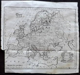
Sold2021Lochhead (Pub) 1811 Rare Map. EuropeCopper Engraved Map Published 1811 by William Lochhead, Berwick for "Modern Geography: And a Compendious General Gazetteer" Rare. Folds as issued. Paper Size: 12 x 10.5 inch (30 x 27cm) Some tone spotSee Sold Price
Sold2021Lochhead (Pub) 1811 Rare Map. ItalyCopper Engraved Map Published 1811 by William Lochhead, Berwick for "Modern Geography: And a Compendious General Gazetteer" Rare. Folds as issued. Paper Size: 10.5 x 10 inch (27 x 26cm) Very minor tonSee Sold Price
Sold2021Lochhead (Pub) 1811 Rare Map. Netherlands Holland"The Severn United Provinces with the Dutch and Austrian Netherlands" Copper Engraved Map Published 1811 by William Lochhead, Berwick for "Modern Geography: And a Compendious General Gazetteer" Rare.See Sold Price
Sold2021Tallis, John (Pub) 1852 Map. England & WalesSteel Engraved Map with Original Outline Hand Color Published 1852-56 by John Tallis, London for "The Universal Pronouncing Dictionary" by Thomas Wright. Drawn & Engraved by John Rapkin. Centre fold aSee Sold Price
Sold2024Russell & Allen (Pub) 1812 Map. England & WalesFolio Copper Engraved Map Published 1812 by Russell and Allen, Manchester for "A New And Commercial System Of Geography" Paper Size: 15.5 x 9 inch (39 x 23cm) Some toning presentSee Sold Price
Sold2021Tallis, John (Pub) 1852 Map. England and WalesSteel Engraved Map with Original Outline Hand Color Published 1852-56 by John Tallis, London for "The Universal Pronouncing Dictionary" by Thomas Wright. Drawn & Engraved by John Rapkin. Centre fold aSee Sold Price
Sold2022Kearsley (Pub) 1802 Map. England and WalesCopper Engraved Map Published 1802 by George Kearsley, London for "The English Encyclopaedia..." Paper Size: 10.5 x 8 inch (27 x 21cm) Very minor toning. Good ConditionSee Sold Price
Sold2021Lochhead (Pub) 1811 Lot of 3 Ethnic/Costume PrintsCopper Plates Published 1811 by William Lochhead, Berwick for "Modern Geography: And a Compendious General Gazetteer" Rare. Paper Size: 8 x 5 inch (21 x 13cm) Very minor toning. One with tiny Ink annoSee Sold Price
Sold20181814 ATLAS Maps of England & Wales Scotland Color Nav1814 ATLAS Maps of England & Wales Scotland Color Navigation Travel John Cary An incredible atlas consisting of 42 color maps of Great Britain by John Cary. The atlas covers cities in England, Wales,See Sold Price
Sold20201798 1ed Cary ROADS New Itinerary England Wales1798 1ed Cary ROADS New Itinerary England Wales Topography Atlas Travel Guide John Cary was a famous English cartographer from the 18th-century. Cary gained his reputation as a map maker from his workSee Sold Price
Sold2024Ptolemy & Magini, pub. 1620 - Map of the British Isles (England, Scotland, Ireland) / Verso: Map ofThis early map engraving is from Claudius Ptolemaeus (Ptolemy) and Giovanni Antonio Magini's Geografia cio? Descrittione Universale della Terra Partita in due volumni, Nel Primo de' quali si contengonSee Sold Price
Sold2018Bacons Motor Road Map: England & Wales, North. c.1920sTitle/Content of Map:Bacons Motor Road Map: England & Wales, North. c.1920s Date: c.1920s Cartographer: Bacons Motor Road Maps Material/Medium: Folded in boards color map reinforced with original gauzSee Sold Price
Sold2018Johnson and Ward Colored Map England & WalesEngland and Wales. With list of English and Welsh counties. Foxing. 25" X 17" (33" X 24")See Sold Price
Sold2021Guthrie, William 1806 Map. England & WalesCopper Engraved Map Published 1806, London for "A New Geographical, Historical and Commercial Grammar..." by William Guthrie. The maps are by John Senex, Thomas Kitchin and others. Folds as issued. PaSee Sold Price
Jun 07Freeman's | HindmanMURCHISON, Roderick Impey, Sir. The Silurian System. 1839. COMPLETE WITH VERY RARE HAND-COLOREDUS$1,500
22 hrs LeftTrillium Antique Prints & Rare BooksDe Jode, Rare, pub. 1593 - Map of the Holy Land (Descriptio Et Situs Terrae Sanctae Alio NomineUS$100(1 bid)
22 hrs LeftTrillium Antique Prints & Rare BooksDe Jode, Rare, pub. 1593 - Map of Kingdom of Napoli, Italy (Neapolitani Regni exacta ac diligensUS$130(3 bids)
22 hrs LeftTrillium Antique Prints & Rare BooksDe Jode, Rare, pub. 1593 - Map of Hainut, Belgium (Hannoniae Comitatus Descriptio)US$100(1 bid)
May 25Trillium Antique Prints & Rare BooksDe Jode, Rare, pub. 1593 - Map of Europe (Nova Totius Europae Tabula)US$100
Jun 02Schilb Antiquarian Rare Books1871 Alfred the Great King of England MAP Battle of Ashdown Vikings Thom HughesUS$125(3 bids)
May 25Trillium Antique Prints & Rare BooksDe Jode, Rare, pub. 1593 - Electors of the Holy Roman Empire (Ordines Sacri Romani Imp: Ab OttoneUS$100
Jun 02Schilb Antiquarian Rare Books1797 Polwhele DEVONSHIRE Devon England Exeter Archbishops South Wales HUGE FOLIOUS$2(2 bids)
6 days LeftPotter & Potter Auctions[BRITISH CAVALRY]. British Officer’s Sabretache, 10th (Prin...US$1,000
Jun 02Schilb Antiquarian Rare Books1803 King Charles II Escape from Worcester English Civil War Samuel Pepys RAREUS$3(3 bids)
22 hrs LeftTrillium Antique Prints & Rare BooksPtolemy & Magini, pub. 1620 - 4 Maps of the Holy Land, Palestine, Persia, Turkey, EgyptUS$50
22 hrs LeftTrillium Antique Prints & Rare BooksPtolemy & Magini, pub. 1620 - 3 Maps of part of AfricaUS$50
May 25Trillium Antique Prints & Rare BooksPtolemy & Magini, pub. 1620 - 4 Maps of European Countries: Spain, Portugal, France, & GreeceUS$50
May 25Trillium Antique Prints & Rare BooksPtolemy & Magini, pub. 1620 - 3 Maps of Italy: Rome, Naples, LombardiaUS$50
6 days LeftPotter & Potter Auctions[POTTERY]. [NELSON, Lord Horatio (1758-1805), subject]. Eng...US$300
1818 AuctioneersTopography. Roscoe, Thomas - Wanderings and Excursions in North Wales. London: C. Tilt; et al. No£5
1818 AuctioneersDecorative cloth bindings. Four books: The Empire Annual for Girls. London: 1910; Other Men's Minds.£24(5 bids)
Jun 02Schilb Antiquarian Rare Books1897 History of British Empire England Scotland Canada James II MAPS India 6vUS$3(2 bids)
22 hrs LeftTrillium Antique Prints & Rare BooksBraun & Hogenberg, pub. 1575 - View of Chios, GreeceUS$120(2 bids)


![[BRITISH CAVALRY]. British Officer’s Sabretache, 10th (Prin... (1 of 3)](https://p1.liveauctioneers.com/928/328184/176813488_1_x.jpg?height=282&quality=70&version=1714496988)


![[POTTERY]. [NELSON, Lord Horatio (1758-1805), subject]. Eng... (1 of 2)](https://p1.liveauctioneers.com/928/328184/176813314_1_x.jpg?height=282&quality=70&version=1714496988)


