Sold2016Bowen map of North Africa 1747Heading: (Map) Author: Bowen, Emanuel Title: A New & Accurate Map of the Western Parts of Barbary [on sheet with] A New & Accurate Map of the Eastern Parts of Barbary Place Published: London PublisherSee Sold Price
Sold2017Antique Britannica War/Battle Map of New York, 1903Title/Content of Map: 'New York, Northern and Eastern part' The sites of important battles and their dates are marked on this map for the following conflicts: War of 1812, American Revolutionary War (See Sold Price
Sold2016MAP OF NEW YORK, THOMAS KITCHIN, 1756A MAP OF THE EASTERN PART OF THE PROVINCE OF NEW YORK, WITH PART OF NEW JERSEY, showing Pennsylvania, New York state, Long Island, Connecticut and New Hampshire, with Lake OntarioSee Sold Price
Sold2022[MAPS & ATLASES]. COLTON, J.H. (1800-1893). Colton's New Topographical Map of The States Of[MAPS & ATLASES]. COLTON, J.H. (1800-1893). Colton's New Topographical Map of The States Of Virginia, Maryland and Delaware, Showing Also Eastern Tennessee & Parts Of Other Adjoining States. New York:See Sold Price
Sold20201873 Lloyd Map of Parts of Eastern and Midwestern US --Title/Content of Map: 1873 Lloyd Map of Parts of Eastern and Midwestern US -- County Map of New York, New Jersey, Pennsylvania, Ohio, Deleware, Maryland, Virginia, West Virginia, Province of Ontario CSee Sold Price
Sold2021Dolph & Stewart 30s Map Columbia County NY Large FolioMap of Columbia County with Eastern part of Greene County, New York, by Dolph & Stewart, circa 1930s. This is a oversized hardcover bound version of what would be tiles from a large wall-mounted mSee Sold Price
Sold2023MAP: United States - East Coast. Connecticut - New York. Long Island Sound - Eastern PartDescription: United States - East Coast. . Connecticut - New York. Long Island Sound - Eastern Part. Published at Washington D.C. US Department of Commerce, Environmental Science services AdministratiSee Sold Price
Sold2018Cassini: Antique Map of Central America, 1798Title/Content of Map: La Parte Orientale Dell'Antico, E Nuovo Messico Con Florida E La Bassa Luigiana . . . 1798 The Eastern Part Of Ancient And New Mexico With Florida And Lower Luisiana Date PrintedSee Sold Price
Sold2020Nautical Map / Sea Chart, #1212 Eastern Long IslandDescription: Nautical Map / Sea Chart, United States East Coast, Connecticut - New York, Long Island Sound, Eastern Part, 12th edition feb 10 / 69 ; all measurements are approximate; Folded; ShippingSee Sold Price
Sold2024A framed 1844 Mitchell map of New EnglandA hand colored copy of S. Augustus Mitchell's Map of the New England or Eastern States, published in 1844, showing also parts of New York, New Brunswick and "Canada East", as Lower Canada was known frSee Sold Price
Sold2022Scarce 1757 map of America in Seven Years' WarMap published in the middle of the French and Indian War. Shows the theater of conflict between eastern Lake Ontario and New England. The war was fought between 1754 and 1763 and was part of a broaderSee Sold Price
Sold2022Scarce Texas map (eastern part) from Asher & Adams,County map of Eastern Texas extends from Louisiana west to beyond San Antonio and features the railroad system of that time. Features numerous railroads still in their infancy, along with proposed futSee Sold Price
Sold2016George Cram: Map of Eastern Part of Quebec, 1891Map: Eastern Part of Quebec Maker: George Cram Date: 1891 Size: 13.5 x 21.75 inches For "The Home Knowledge Atlas" George F. Cram (1842-1928) served in the U.S. Army during the American Civil War. AftSee Sold Price
Sold2022Map AssortmentMap Assortment (4) items including 'A New Map of Part of the United States of North America, Exhibiting The Western Territory' by John Carey, London 1805; 'Geographical, Statistical and Historical MapSee Sold Price
Sold2017Cary Map of the Western Territory, Kentucky,Cary, John (British, 1754-1835). A New Map of Part of the United States of North America, Exhibiting the Western Territory, Kentucky, Pennsylvania, Maryland, Virginia &c. Also, the Lakes Superior, MicSee Sold Price
Sold2017Cary: US Western Territory/Great Lakes Region Map, 1805Map: A New Map of Part of the United States of North America, exhibiting the Western Territory, Kentucky, Pennsylvania, Maryland, Virginia &c., also the lakes Superior, Michigan, Huron, Ontario & ErieSee Sold Price
Sold2023John Cary, Map of Part of United States, C1800John Cary, "A New Map of Part of the United States of North America" (northeast coast), hand-colored engraving, London 1799-1807, 18" x 20", matted and framed 22 1/2" x 25 1/2". Provenance: MarbleheadSee Sold Price
Sold20161806 John Carey Map of North AmericaDESCRIPTION: 1806 John Carey A New Map of Part of the United States of North America in two parts. Handcolored engraving on wove paper. MEASUREMENTS: 20-7/8" x 25" CONDITION: Hinged at center. Two minSee Sold Price
Sold2020IRAN IRAQ The Eastern part of the Ancient PersianTITLE/CONTENT OF MAP: 'THE EASTERN PART OF THE ANCIENT PERSIAN EMPIRE' The top image on the right hand side shows the entire map. To view a close up of the map showing the level of printed detail, pleSee Sold Price
Sold20201889 Map of Eastern TexasAuthor: Cram Title: 1889 Map of Eastern Texas Medium: Ink on Paper Dimensions: 14.5"X22" Map of Eastern part of Texas dated 1889. Engraved and published by George Cram in Chicago. Double folio map. VeSee Sold Price
Sold2017Antique Britannica War/Battle Map of Pennsylvania, 1903Title/Content of Map: 'Pennsylvania, Eastern part; Inset map of Philadelphia and Vicinity' The sites of important battles and their dates are marked on this map for the following conflicts: American RSee Sold Price
Sold20231817 Hall Map of Persia to Kazakhstan -- Map of the Eastern Part of Persia with Afghanistan,Title: 1817 Hall Map of Persia to Kazakhstan -- Map of the Eastern Part of Persia with Afghanistan, Bactriana, Trans-Oxiana &c Cartographer: S Hall Year / Place: 1817, London Map Dimension (in.): 20x1See Sold Price
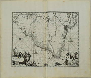
Sold20231671 Ogilby Map of Brazil -- BrasiliaTitle: 1671 Ogilby Map of Brazil -- Brasilia Cartographer: J Ogilby Year / Place: 1671, London Map Dimension (in.): 11.3 X 13.8 in. This is an excellent map of the eastern part of Brazil. There is anSee Sold Price
Sold2022La Polonia divisa ne' suoi Palatinati…. Poland Lithuania &c. ZATTA 1783 mapTITLE/CONTENT OF MAP: 'La Polonia divisa ne' suoi Palatinati tratta dall' Atlante Polacco del Sig. Rizzi Zanoni' "Poland divided into its Palatinates or Voivodeships". The map covers the eastern partSee Sold Price
Jun 08Early American History Auctions1853 Map of Portion of British North America and Gulf of St. Lawrence, by Henry PerleyUS$260
2 days LeftJasper52BRAZIL.Shows"Proposed Federal District" (now Brasilia);Rio de Janeiro 1903 mapUS$8
2 days LeftJasper52Extremité Meridionale de l'Amérique Tierra del Fuego Magellan Str BONNE 1788 mapUS$35
Jun 06Freeman's | HindmanMELVILLE, Herbert (1819-1891). Typee: A Peep at Polynesian Life. During a Four Months' Residence inUS$200
Jun 08Simpson Galleries, LLC.JULIUS BIEN (1826-1909) AN AMERICAN CIVIL WAR RECONNAISSANCE MAP, "Map of Texas and Part of NewUS$100
2 days LeftJasper52SOUTHERN CENTRAL AMERICA. Mosquito New Granada Venezuela. ETTLING 1863 old mapUS$35
2 days LeftJasper52Amér Mér Colombie & Brésil 9 Peru Colombia Amazonas Brazil VANDERMAELEN 1827 mapUS$70
2 days LeftJasper52AMAZONIA showing "El Dorado?" & Missions. Brazil Ecuador Colombia SDUK 1874 mapUS$120
2 days LeftJasper52AMAZONIA.Showing "El Dorado?", missions & tribes. Brazil Ecuador.SDUK 1844 mapUS$130


![Bowen map of North Africa 1747: Heading: (Map) Author: Bowen, Emanuel Title: A New & Accurate Map of the Western Parts of Barbary [on sheet with] A New & Accurate Map of the Eastern Parts of Barbary Place Published: London Publisher](https://p1.liveauctioneers.com/642/86438/44449747_1_x.jpg?height=310&quality=70&version=1458591928)


![[MAPS & ATLASES]. COLTON, J.H. (1800-1893). Colton's New Topographical Map of The States Of: [MAPS & ATLASES]. COLTON, J.H. (1800-1893). Colton's New Topographical Map of The States Of Virginia, Maryland and Delaware, Showing Also Eastern Tennessee & Parts Of Other Adjoining States. New York:](https://p1.liveauctioneers.com/197/265299/138516337_1_x.jpg?height=310&quality=70&version=1666051328)