Sold2022Hamilton Farm James Cox Brady ResidenceHunterdon Somerset & Morris Counties Map is approx 33 1/2" x 43 1/2"See Sold Price
Sold2018MAP OF NEW JERSEY COUNTIESOf Hamilton Farm, Hunterton, Morris, and Somerset Counties. Frame size: 27"h x 22 1/2"wSee Sold Price
Sold2023"Counties of England" Book, Circa 1834"Atlas of the Counties of England" by C&J Greenwood, 1834, comprising partially colored surveys and maps, with folio binding. Provenance: Phyllis Lucas Gallery, NYC. [25 3/4" H x 17 1/4" W]. Cover disSee Sold Price
Sold2022Yorkshire.- Greenwood (Christopher) Map of the County of York, made on the Basis of Triangles in theNO RESERVE Yorkshire.- Greenwood (Christopher) Map of the County of York, made on the Basis of Triangles in the County, determined by Lieut. Col. Wm. Mudge, county map in six sections, with calligraphSee Sold Price
Sold2023Map of Somerset County, New JerseyMap of Somerset County with inset of Somerville lower right, hand-colored lithograph by J. W. Otley and J. Keily, printed by Lloyd Van Derveer, Camden, NJ, 1850 Overall: 47-3/4"h x 40"w Sight: 44-3/4"See Sold Price
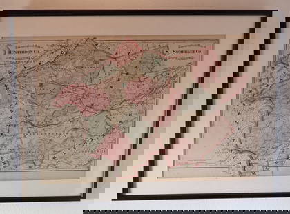
Sold2023Hearne Brothers Somerset County NJ MapPolyconic Projection map. Approx 50" x 65"See Sold Price
Sold20211872 Morgan County, Illinois Atlas & History Book1872 Morgan County, Illinois Atlas & History Book. (1) Atlas Map of Morgan County Illinois, by Townships, 1872. Measures 17 3/4" x 14 3/4". (1) A History of Lawrence, Kansas: From the First SettlementSee Sold Price
Sold2016Map of Colorado, 1895Title: Map of Colorado Original engraving from "Atlas of the World" by Rand McNally Date: 1895 Dimensions: 21 x 27 1/2 inches Description: Map includes counties, geographical landmarks, streets and poSee Sold Price
Sold2016Map of Utah, 1895Title: Map of Utah Original engraving from "Atlas of the World" by Rand McNally Date: 1895 Dimensions: 14 x 21 1/4 inches Description: Map includes counties, geographical landmarks, streets and populaSee Sold Price
Sold2016Map of Idaho, 1895Title: Map of Idaho Original engraving from "Atlas of the World" by Rand McNally Date: 1895 Dimensions: 14 x 21 1/4 inches Description: Map includes counties, geographical landmarks, streets and populSee Sold Price
Sold2022Surrey.- Greenwood (C. & J.) Map of the County of Surrey from an actual Survey, made in the yearsNO RESERVE Surrey.- Greenwood (C. & J.) Map of the County of Surrey from an actual Survey, made in the years 1822 and 1823..., large county map, with vignette of Kew Palace, compass rose, calligraphicSee Sold Price
Sold2016Antique Map, County of Southampton, Greenwood & Co.Greenwood & Co. (British, 19th century), "Map of the county of Southampton from an Actual Survey, made in the years 1825 & 1826," hand-colored copper-engraved map, engraved by J. and J. Neele, publishSee Sold Price
Sold20222 PC. FRAMED EARLY ENGLISH MAPS2 PC. FRAMED EARLY ENGLISH MAPS: Comprising; 1- Hand-colored Oxford Shire map, by Robert Morden. 1- An accurate map of the county of Bedford divided into its hundreds. Drawn from a late survey, & illuSee Sold Price
Sold20232 Vintage Massachusetts Maps Lunenburg & Fitchburg2 vintage, possibly antique maps of county’s within Massachusetts. 1 map reads Lunenburg, written on lower half in graphite, 1870 the other reads Fitchburg. Both maps appear pulled from a book withSee Sold Price
Sold20242 19th Century New York Maps Gamble & Colton2 19th century maps of New York. Colton's Map of New York and the Adjacent Cities, J.H. Colton 1855, 16 1/4" x 26 1/4" (with frame 28 1/8" x 38"); County Map of the State of New York, W.H. Gamble, 187See Sold Price
Sold2019Christopher Greenwood (1786-1855) and John GreenwoodChristopher Greenwood (1786-1855) and John Greenwood (fl. 1821-1840) Map of the County of Essex, from an actual Survey made in the year 1824, by C & J Greenwood, 13, Regent St. Pall Mall, London, corrSee Sold Price
Sold2019Vintage Road Maps (14)Including 1980-1981 New Jersey map & guide; (3) Somerset & Hunterdon Counties New Jersey map; Burlington Bridges Area Road map; Northern Hunterdon County, NJ map; Sunoco New York map; Texaco Florida,See Sold Price
Sold20223 FRAMED CHARLESTON COUNTY MAPSThree (3) Framed Charleston County Maps showing Neighborhoods. Includes 1- The Peninsula of Charleston.2- East Cooper; Mt. Pleasant, Isle of Palms, Sullivans Island. 3- Sea Islands; Kiawah, Seabrook,See Sold Price
Sold2021Colton's Pennsylvania Virginia Delaware and MarylandTitle: Colton's Pennsylvania Virginia Delaware and Maryland Cartographer: JOHNSON & BROWNING Publisher: JOHNSON & BROWNING Size: 17.1 X 23.75 Pastel map showing counties separately colored, towns, towSee Sold Price
Sold2016Map of Wyoming, 1895Title: Map of Wyoming Original engraving from "Atlas of the World" by Rand McNally Date: 1895 Dimensions: 21 1/4 x 14 inches Description: Map includes counties, geographical landmarks, streets and popSee Sold Price
Sold2016Antique Map, County of Dorset from an Actual Survey,Greenwood & Co. (British, 19th century), "Map of the county of Dorset from an Actual Survey, made in the years 1825 & 1826," 1829, hand-colored copper-engraved map, engraved by H. Frost, published inSee Sold Price
Sold2023An 1860 Map, Counties of New York, New Hampshire, Etc...Hand colored lithograph, by Samuel Augustus Mitchell (1790-1868). :County Map of the States of New York, New Hampshire, Vermont, Massachusetts, Rhode Island and Connecticut". Dimensions:15 1/2" x 23 1See Sold Price
Sold2017Mitchell: Antique County Map of Texas, 1870Map: County Map of Texas Cartographer: S. A. Mitchell Place & Date: Philadelphia / 1870 Size: 13 1/4" x 10 3/4" Condition: full color; light overall age toning The beautifully detailed and colored couSee Sold Price
Jun 08Early American History Auctions1720 Colonial Northumberland County Virginia Manuscript Deed and Map PlotUS$400


!["Counties of England" Book, Circa 1834: "Atlas of the Counties of England" by C&J Greenwood, 1834, comprising partially colored surveys and maps, with folio binding. Provenance: Phyllis Lucas Gallery, NYC. [25 3/4" H x 17 1/4" W]. Cover dis](https://p1.liveauctioneers.com/1221/310017/167287172_1_x.jpg?height=310&quality=70&version=1702345351)


