Sold2021Blaeu 1647 Map of Near & Middle EastDESCRIPTION: This map, created by Willem Blaeu and Joan Blaeu, features a title cartouche " Turcicum Imperium " showing a Turkish Sultan on his throne, flanked by armed allegorical figures. Also incluSee Sold Price
Sold2024Antique map of Virginia - Florida by Blaeu W. 1642-43Virginia and Florida. "Virginiae partis australis, et Floridae partis orientalis, interjacentiumque regionum nova descriptio". Orig. copperplate engraving, W. J. Blaeu, published by C. and J. Blaeu inSee Sold Price
Sold2016Blaeu, W.: Walachia, Servia, Bulgaria, Romania Map 1635Map: Walachia, Servia, Bulgaria, Romania Publishing: Blaeu, W.: Amsterdam Date: 1635 Size: 15 x 20 inches Early edition of a very attractive map of the Balkans, shown during the occupation by the OttoSee Sold Price
Sold2021Two Early Maps of PolandA map of Poland and Silesia, by W. & J. Blaeu circa 1640 and a map of Poland - Grodków and Nysa by J. Blaeu circa 1660. Dimensions: The frames are 17" x 23" and 19" x 23".See Sold Price
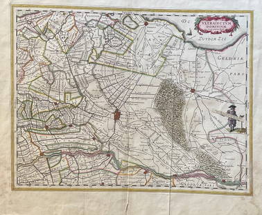
Sold2023The Netherlands Map. The region Around the city of Utrecht. 1660?s by W. BlaeuTitle: The Netherlands Map. The region Around the city of Utrecht. 1660?s by W. Blaeu Date/Period: 1660?s Materials: Hand colored copper plate engraved Size: 22 x 19 1/2'' Netherlands regional map cenSee Sold Price
2016Montgomery County, Wales 1646Map Title: Mervinia et Montgomeria Comitatus Publisher: Blaeu, W. Amsterdam Date: 1646 Size: 15 x 19.75 inches. Attractive map of part of Wales showing what is now part of the county of Powys. The carSee Sold Price
Sold2017Blaeu Map of BrazilMaritima Brasiliae Universa. Joan Blaeu (1596-1673). Engraved map with original color in part. Amsterdam: Blaeu, 1647. 21 x 24 1/2 inches sheet, 32 1/2 x 36 inches framed. This separately issued and rSee Sold Price
2022Blaeu, Johannes (Netherlands, 1596-1673) "The New World Map" Double Hemisphere World Map C. 1664Nova et Accuratissima Totius Terrarum Orbis Tabula Translated "The New World Map", Hand Colored w/ Elaborately Decorated Spandrels.   Sight View 16" x 21-1/2", Overall View 21" x 25-1/2"See Sold Price
Sold20241640 Blaeu Map of Sicily -- Sicilia RegnumTitle: 1640 Blaeu Map of Sicily -- Sicilia Regnum Cartographer: W Baeu Year / Place: 1640 c., Amsterdam Map Dimension (in.): 14.9 X 19.5 in. This is a strikingly attractive larger map of the Kingdom oSee Sold Price
Sold2019France Antique Map & View, 17th C.Descriptio Veromanduorum, Antique map, Blaeu, Amsterdam, mid 17th C. W/ view Mommedy on 2 separate sheets, engraving by Israel Silvestre, 1669. 19 1/2" x 26 1/4".See Sold Price
Sold2018Blaeu: Antique Map of Europe, 1650Title/Content of Map: Highly decorative Map by Blaeu Date Printed: c1650 Cartographer: W. Blaeu Material/Medium: Paper Size: 19" x 24" Hand colored engraved Map. French text on Verso. Magnificent examSee Sold Price
Sold2016G. BLAEU ENGRAVED MAP ANGLICA REGNUMG. BLAEU, ENGRAVED MAP, ANGLICA REGNUM, 15" X 21":Hand colored. Paul Victorius custom frame. Engraved map H 15 1/4", W 21". Custom frame 26" x 30".See Sold Price
Sold2022TWO EUROPEAN MAPS.Mid 17th century, hand colored engravings on laid paper. William Blaeu map of "Karstia, Carniola, Histria et Windorum Marchia". Text on back. Crease. 18.5"h. 22.75"w. And Nicolaum Visscher map of "BelSee Sold Price
Sold2015Vintage Map, Willem Janszoon Blaeu, Virginae PartisWillem Janszoon Blaeu (Dutch, 1571-1638) "Virginiae Partis Australis, et Floridae," copper engraved map, image: 15"h x 20"w, overall (with frame): 18.5"h x 23"wSee Sold Price
Sold2015Printed Map, Willem Janszoon BlaeuWillem Janszoon Blaeu (Dutch 1571-1638), "Stiria Steymourck," circa 1650, hand-colored copper engraved map, sheet: 16"h x 21"wSee Sold Price
Sold2018Blaeu: Antique Map of Anglo Saxon Britain, 1645Title/Content of Map: Map of Anglo Saxon Britian Date Printed: 1645 Cartographer: W. Blaeu Material/Medium: Paper Size: 19" x 23" Anglo Saxon Britian. Hand colored copperplate engraved. Latin text onSee Sold Price
Sold20231631 c. Blaeu Map of the Americas -- Americae nova TabulaTitle: 1631 c. Blaeu Map of the Americas -- Americae nova Tabula Cartographer: W Blaeu Year / Place: 1631 c., Amsterdam Map Dimension (in.): 14.3 X 18.3 in. This is a very nice map portraying the seveSee Sold Price
Sold2017Blaeu: Antique Map of Brazil, 1634Map: Novus Brasiliae Typus Cartographer: Blaeu Place & Date: Amsterdam / 1634 (circa) Size: 19 1/2" x 15" Condition: b&w; cleaned; some minor spotting; centerfold reinforced Blaeu's superb, Hondius-deSee Sold Price
Sold2024Willem Blaeu, Map of The AmericasAmsterdam, 1617. Together with "Early Maps" by Tony Campbell, Abbeville Press and "The United States in Old Maps and Prints, Eduard Van Ermen. 3 pieces Sight size: 16-1/2"h x 22"w Overall: 23-1/2"h xSee Sold Price
Sold2018Blaeu Map of Europe -- Europa Recens DescriptaTitle/Content of Map: Blaeu Map of Europe -- Europa Recens Descripta Date: 1635, Amsterdam Cartographer: W Blaeau Size: 16.1 X 21.9 in. This is a grand, large, classic map of Europe, produced at the gSee Sold Price
Sold2017Blaeu: Antique Map of Iceland, 1630Map: Tabula Islandia Cartographer: Blaeu Place & Date: Amsterdam / 1630/1690 Size: 19 1/2" x 15" Condition: b&w, very light overall age toning; some slight staining along outer edges of wide margins ASee Sold Price
Sold2022BLAEU 1659 MAP OF IRELANDFrench text verso. Dimensions: H 16" x W 18.75" Condition: With center fold as published, left and right margins trimmed. Faint coloring. Age toning.See Sold Price
Sold20221649 Blaeu Map of the Spice Islands -- Moluccae Insulae CeleberrimaeTitle: 1649 Blaeu Map of the Spice Islands -- Moluccae Insulae Celeberrimae Cartographer: W Blaeu Year/Place: 1640, Amserdam Dimensions: 14.7 X 19.2 in. Description: This is an excellent map of IndoniSee Sold Price
Sold2023Map, Joan BlaeuJoan Blaeu (Dutch, 1596-1673), "Ukrainae pars, quae Podolia Palatinatus vulgo Dicitur," circa 1650, copper engraved map with hand coloring, unsigned, overall (with frame): 27.25"h x 30.25"wSee Sold Price
BonhamsBLAEU (WILLEM AND JAN) Toonneel des Aerdrycks oft Nieuwe Atlas...Vierde Deel, Amsterdam, Jan Bla...£8,000
Featured12 hrs LeftJasper521640 Blaeu Map of Central France with Clemont-Ferrand as Center -- AuvergneUS$150
Jun 22Willis Henry Auctions Inc.TWO HAND-PAINTED FLOOR MATS 20th c. prepared heavy canvas, painted and stenciled with the "Tree ofUS$150
Jun 14DuMouchellesRigobert Bonne (French, 1727-1794) Hand Colored Engraving Ca. 18th Century, Les Etats Unis DeUS$50(1 bid)
Jun 14DuMouchellesWilliam H. Gamble (American, B. 1863) Hand Colored Engraving, Ca. 1863, "County Map of Michigan AndUS$50(1 bid)
3 days LeftFreeman's | Hindman[MAP]. TODESCHI, Pietro. [Nova et Acurata Totius Americae Tabula auct. G.I. Blaeu] America quartaUS$5,000
Featured12 hrs LeftJasper521831 Woodbridge Map of South America and Africa -- Comparative, Geographical & Statistical Map ofUS$70(1 bid)
Jun 13Swann Auction Galleries(PICTORIAL MAPS.) Annie Olmstead Peet; and Roscoe W. Smith. Orange County Before 1810.US$300
6 days LeftWinter Associates Three historical engraved maps of the Caribbean, ranging from 1616-1814, each hand colored, framedUS$100(1 bid)
4 days LeftBrzostek’s Auction Service, Inc.Antique Seneca-Cayuga Wall map 1859 by Arz Dawson, PhiladelphiaUS$10


![[MAP]. TODESCHI, Pietro. [Nova et Acurata Totius Americae Tabula auct. G.I. Blaeu] America quarta (1 of 1)](https://p1.liveauctioneers.com/197/329395/177650542_1_x.jpg?height=282&quality=70&version=1715364962)
![Arizona Library (5) 1915-67 [182280] (1 of 9)](https://p1.liveauctioneers.com/2699/331494/178785508_1_x.jpg?height=282&quality=70&version=1717094654)


