Sold2022Ancient Holy land. 12 tribes 1810 by DelalainAncient Holyland showing the twelve tribes. 1810 published in ‘Atlas tables elementaires de geographie ancienne et moderne’, Paris, by Auguste Delalain. Hand-colored outline copperplate enSee Sold Price
Sold20231810 Published,Ancient world Roman empire mapOrigin:France Date/Period:19th.c Material:Paper Approximate Size: 9 1/4 x 8'' Additional Information: 1810 Published, in Atlas tables elementaires de geographie ancienne et moderne', Paris, by AugusteSee Sold Price
Sold2022Europe 1810 by DelalainEurope. 1810 published in ‘Atlas tables elementaires de geographie ancienne et moderne’, Paris, by Auguste Delalain. Hand-colored outline copperplate engraved. Excellent condition. 13 1/2See Sold Price
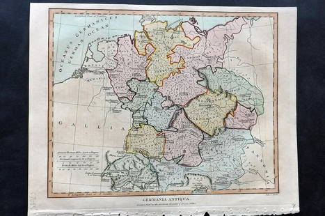
Sold2021Wilkes, John 1807 Hand Col Map. Ancient Germany"Germania Antiqua" Finely Hand Colored Copper Engraved Map Published 1796-1828 London for "Encyclopaedia Londinensis, or universal dictionary of arts, sciences and literature" by John Wilkes et al. PaSee Sold Price
Sold2016Map of Ancient Germany by JanssonHeading: Author: Jansson, Jan Title: Germaniae Veteris, Typus Place Published: Amsterdam Publisher: Date Published: c.1640 Description: Copper-engraved map, hand-colored inSee Sold Price
Sold2019Fenning & Collyer 1765 Map of Germany & Poland"A Map of the Kingdom of Prussia and Polish Prussia" Copper Engraved Map Published 1764-65, London for "A New System of Geography: or, A General Description of the World" by Daniel Fenning & Joseph CoSee Sold Price
Sold2022Lyttleton, George 1810 Antique Map of Germany"Germany Exhibiting the present seat of War 1805" Copper Engraved Map Published 1810, London for "The History of England..." by George Courtney Lyttleton. Folds as issued. Paper Size: 17.5 x 16 inch (See Sold Price
Sold2019Lyttleton, George 1810 Hand Col Map of Germany"Germany Exhibiting the present seat of War 1805"Hand Coloured Copper Engraved Map Published 1810, London for "The History of England..." by George Courtney Lyttleton. Folds as issued. Paper Size: 17.See Sold Price
Sold2019Delamarche, Felix 1829 Maps (2) Ancient France, Germany"Germania Antiqua" and "Galliae Antiquae" Copper Engraved Maps Published 1829, Paris for "Atlas de La Geographie..." by Felix Delamarche. Contemporary outline hand colour. Centre fold as published. PaSee Sold Price
Sold2016Holy Roman Empire 1805Map Title: The Holy Roman Empire in its Final Year Germany/ Poland/ Czech Republic/ Austria/ Netherlands (A New Map Of Germany Divided Into Its Circles). Published: Laurie & Whittle, London Date: 1805See Sold Price
Sold2019Mallet, Alain 1683 Map of Germany & Part of Poland"Allemagne en General" Copper Engraved Map Published 1683, Paris for "Description de l'Univers" by Alain Manesson Mallet. French text to verso. Paper Size: 8 x 5 inch (20 x 13cm) Good ConditionSee Sold Price
Sold2018Stieler, Adolph 1874 Lot of 10 Maps + Title PageIncl USA, Spain, Germany, East Germany/Poland, UK and France. Plus title page. Steel Engraved Map Published 1874, Gotha, Germany for "Hand-Atlas über alle Theile der Erde und über das Weltgebäude"See Sold Price
Sold2021Dussieux, Louis 1859 Mixed Lot of 6 MapsIncl Europe, UK, France, French Empire, Ancient Britain/Germany and Persian Empire/Asia Minor. Steel Engraved Map Published 1859, Paris for "Atlas Complet de Geographie Elementaire" by Louis Dussieux.See Sold Price
Sold2019Delamarche, Felix 1829 Lot of 6 Ancient Europe MapsIncl Ancient France, Spain, Germany, Greece, Alexander the Great Empire, and Asia Minor. Copper Engraved Maps Published 1829, Paris for "Atlas de La Geographie..." by Felix Delamarche. Contemporary ouSee Sold Price
Sold2021Turner, Richard 1808 Lot of 12 Miniature MapsIncl Germany, Holland, Spain/Portugal, Switzerland, Poland/Prussia, Denmark, Sweden/Norway, Russia, Hungary, Turkey, and Great Britain. Copper Engraved Map Published 1808, London for "A New and Easy ISee Sold Price
Sold2020Bartholomew, John 1922 Lot 7 Maps. Baltic, Germany etcIncl Germany West, Germany East, Southern Scandinavia/Denmark, Poland/Czecho-Slovakia, Siberia, Northern Russia/Finland, Baltic States/East Prussia. Large Lithograph Maps Published 1922 by The Times,See Sold Price
Sold2022Encyclo. Britannica 1890's Mix Lot of 14 MapsIncl Ancient Spain, Russia, Saxony, Scotland, Portugal, Serbia/Romania, Poland, New Guinea, New Holland, Huntingdon/Cambridge, Maine & Louisiana. Lithograph Map Published 1875-98, Edinburgh & London fSee Sold Price
Sold20222-sheet map of ancient Egypt by Ortelius 1584Heading: Author: Ortelius, Abraham Title: Aegyptus Antiqua Place Published: Antwerp Publisher: Date Published: 1584 Description: Copper engraved map on two sheets, north anSee Sold Price
Sold2020Suzanne Eisendieck (Germany/Poland) Oil PaintingSuzanne Eisendieck (Germany/Poland 1908 - 1998) 24" H x 20" W oil on canvas titled, "La Grande Jatte." Signed lower right, "Suzanne Eisendieck." Also titled on verso. Suzanne was born in Poland. She sSee Sold Price
Sold2020MONTBLANC Artisan Ed: URBINO RAPHAEL Ltd Fountain PenHeading: Author: Montblanc Artisan Edition Title: Master of Urbino [Raphael Sanzio da Urbino] 18K Gold Limited Edition Filigree Fountain Pen Place Published: Germany Publisher: Date Published: <See Sold Price
Sold2019MONTBLANC Arena di Verona ArtisanHeading: One of 49 Author: Montblanc Artisan Edition Title: Arena di Verona 18K White Gold Limited Edition Fountain Pen Place Published: Germany Publisher: Date Published: 2006 DescriptSee Sold Price
Sold2019Impressive Chinese 6th Cent. Marble Stele of a BuddhistImpressive Chinese 6th Cent. Marble Stele of a Buddhist Trinity 27''x14.5''x7.5''. Exceptional published ancient marble carving from the C.K. Chan Collection. Pictured in color on page 27 of the bookSee Sold Price
Sold2019MONTBLANC Patron 888: PRINCE REGENT Fountain PenHeading: Author: Montblanc Patron of Art Series Title: Prince Regent Limited Edition 888 Fountain Pen Place Published: Germany Publisher: Date Published: 1995 Description:See Sold Price
Sold2019MONTBLANC Albert EINSTEIN Ltd Fountain Pen, SEALEDHeading: Author: Montblanc Title: Albert Einstein Sterling Silver Limited Edition Fountain Pen * SEALED Place Published: Germany Publisher: Date Published: 2012 Description:See Sold Price
2 days LeftGrogan & CompanyFRIEDERICH BERNHARD WERNER, (German, 1690-1776), Map of Venice, 1730US$500
4 days LeftTrillium Antique Prints & Rare BooksSchedel, pub. 1493 - Pair of Pages of Engravings with Biblical ScenesUS$75(1 bid)
4 days LeftTrillium Antique Prints & Rare BooksSchedel, pub. 1493 - 4 Pages of Engravings of Town Views & Historic or Religious PeopleUS$75
4 days LeftTrillium Antique Prints & Rare BooksSchedel, pub. 1493 - 3 Pages of Engravings of Town Views & Historic or Religious PeopleUS$75
4 days LeftTrillium Antique Prints & Rare BooksKollner, Rare - Niagara Falls, Horseshoe Fall, from the Canada SideUS$200
4 days LeftTrillium Antique Prints & Rare BooksKollner, Rare - Capitol, West Side, Washingon, DCUS$200
4 days LeftTrillium Antique Prints & Rare BooksHamilton - 4 Engravings of a Painting from a Grecian VaseUS$100
3 days LeftFrost & NicklausSans Souci Palace Picture Gallery Guide, Potsdam, Germany, in Russian, 1stEd. 1981US$10
5 days LeftPUBLIC SALE1929 Insurance Maps of Brooklyn NY Atlas, Sanborn Hardcover FolioUS$100(2 bids)
3 days LeftFrost & NicklausJan Bialostocki, William Hogarth, 1st East German Ed. 1972, illustratedUS$7
3 days LeftFrost & NicklausJohann Elias Ridinger, Wild Animals & Art of Hunting, 1950 Copper EngravingsUS$7
2 days LeftEldred'sALBRECHT DURER (Germany, 1471-1528), "Rhinoceros", 1515., Woodcut, 8.375" x 11.75". Framed 18.75" xUS$5,000
3 days LeftFrost & NicklausLudwig Von Baldass, Albrecht Altdorfer Monography, German, 1941, illustratedUS$20(1 bid)


![MONTBLANC Artisan Ed: URBINO RAPHAEL Ltd Fountain Pen: Heading: Author: Montblanc Artisan Edition Title: Master of Urbino [Raphael Sanzio da Urbino] 18K Gold Limited Edition Filigree Fountain Pen Place Published: Germany Publisher: Date Published: <](https://p1.liveauctioneers.com/642/176650/88936419_1_x.jpg?height=310&quality=70&version=1597439617)


![[MAPS] 1855 Antique Map of Paris (1 of 3)](https://p1.liveauctioneers.com/7226/343679/186655055_1_x.jpg?height=282&quality=70&version=1726238840)


