Sold2016Map of Ancient Germany by JanssonHeading: Author: Jansson, Jan Title: Germaniae Veteris, Typus Place Published: Amsterdam Publisher: Date Published: c.1640 Description: Copper-engraved map, hand-colored inSee Sold Price
Sold2022MAP, Germany, JanssonSoutheastern Germany. Jan Jansson, Franconiae Nova Descriptio, from Atlas Novus..., 1646 (circa). Hand Color. This elegantly engraved map focuses on the Franconia region of Germany, located in BavariaSee Sold Price
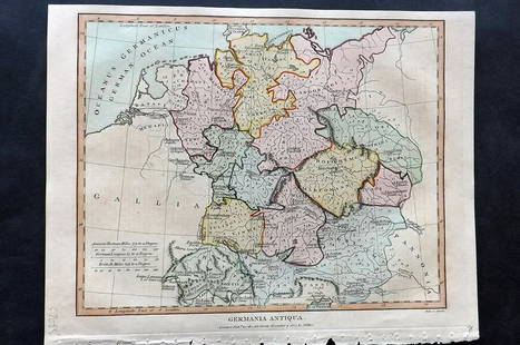
Sold2021Wilkes, John 1807 Hand Col Map. Ancient Germany"Germania Antiqua" Finely Hand Colored Copper Engraved Map Published 1796-1828 London for "Encyclopaedia Londinensis, or universal dictionary of arts, sciences and literature" by John Wilkes et al. PaSee Sold Price
Sold2017Janssonius: Map of Ancient Germany, 1645TITLE/CONTENT OF MAP: 'Germaniae Veteris Nova Descriptio [Ancient Germany newly described]' A map of ancient Germany, based on Ortelius' map, which was in turn based on the writings of Ptolemy, Pliny,See Sold Price
Sold2018Arrowsmith: Antique Map of Ancient Germany, 1828TITLE/CONTENT OF MAP: 'Germania; Vel Regiones intra Rhenum f1. Oceanum, Sinum Codanum, Vistulam f1. Montes Sarmaticos et Danubium f1. Sitae' DATE PRINTED: 1828 IMAGE SIZE: Approx 25.5 x 28.5cm, 10 x 1See Sold Price
Sold20211828 Map of Ancient GermanyAuthor: Hall Title: 1828 Map of Ancient Germany Materials: Ink on Paper Dimensions: 10.5"X8.5" Description: Map of Ancient Germany dated 1828. Part of Butler's Antique World Atlas. Drawn and engravedSee Sold Price
Sold2019Delamarche, Felix 1829 Maps (2) Ancient France, Germany"Germania Antiqua" and "Galliae Antiquae" Copper Engraved Maps Published 1829, Paris for "Atlas de La Geographie..." by Felix Delamarche. Contemporary outline hand colour. Centre fold as published. PaSee Sold Price
Sold20241839. Ancient Germania and Central Europe by MoninTitle/Content: 1839. Ancient Germania and Central Europe by Monin Date: 1839 Medium: Hand colored, engraved Dimensions: 17 1/2" x 12 1/2" Description: Map of Ancient tribal Germany and Central Europe.See Sold Price
Sold2017Jansson: Antique Map of Ancient Sicily, 1630Map: Siciliae Veteris Typus Cartographer: Jan Jansson Place & Date: Amsterdam / 1630 Size: 19 1/2" x 15 1/2" Condition: b&w. very light overall age toning, a few minor spots and slight darkening alongSee Sold Price
Sold2022Maps 1812-1922 Mixed Lot of 46 MapsLot of Lithograph and Engraved Maps. Incl Netherlands, Ancient World, Europe, Greece, Germany, Madedonia, North America, Canada, Netherlands, USA, Malaya, European Battle Plans, Australia, New ZealandSee Sold Price
Sold20191617 map of Malay Peninsula by JannsonEarly seventeenth century Ptolemaic map of ancient Malaysia, Thailand, Burma by Johannes Jansson. Nice hand coloring. Two small tape remnants on back where it had been mounted. 4.875 x 6.625. Reserve:See Sold Price
Sold2015Jansson (Jan) - [Atlas Novus: Germany],single vol. lacking title, 106 mostly regional maps of Germany and northern Europe, but also including a general map of Germany, and classical maps of both Germany and Scandinavia, and several city plSee Sold Price
Sold2022Ancient map of a region of Bavaria, 1628Authentic vintage map of the Rhineland Palatinate of Bavaria in Southern Germany. From an edition of Mercator’s Atlas Minor. Jocodus Hondius created the Atlas Minor in 1607 as a smaller versionSee Sold Price
Sold2021Dussieux, Louis 1859 Mixed Lot of 6 MapsIncl Europe, UK, France, French Empire, Ancient Britain/Germany and Persian Empire/Asia Minor. Steel Engraved Map Published 1859, Paris for "Atlas Complet de Geographie Elementaire" by Louis Dussieux.See Sold Price
Sold2019Maps 19th Cent. Mixed Lot of 11Incl Belgium/Netherlands, Lake Gennesaret, France, Camp of Colonias, Denver, Canaan, Ancient World, Coal Mine Map, Germany and Lake States of the US. Examples by Bryce, Chambers, Encyclopaedia BritannSee Sold Price
Sold2019Delamarche, Felix 1829 Lot of 6 Ancient Europe MapsIncl Ancient France, Spain, Germany, Greece, Alexander the Great Empire, and Asia Minor. Copper Engraved Maps Published 1829, Paris for "Atlas de La Geographie..." by Felix Delamarche. Contemporary ouSee Sold Price
Sold2022Maps 1816-1922 Mixed Lot of 21 Antique MapsIncl Australia, Pacific, USA, North America, and Ancient - Italy, France, Germany, Spain. Examples by Bartholomew, Encyclopaedia Britannica, National Encyclopedia and Cellarius & Patrick. Paper Size:See Sold Price
Sold2017Fantastic Dutch 17th C. map of Japan & adjacent islandsA nice Dutch map of Japan and adjacent islands by Joan Jansson, c. 1660. Title: New and Accurate Japan, Land of Ezo and Adjacent Islands, fully hand-colored with 2 Compass Roses, 4 Galleons and a SeaSee Sold Price
Sold20211640 Jansson Map of Rhine River Area in Netherlands andTitle: 1640 Jansson Map of Rhine River Area in Netherlands and Germany in Part -- Descriptio Fluminum Rheni, Vahalis et Mosae Cartographer: J Jansson Year / Place: c 1640, Amsterdam Map Dimension (in.See Sold Price
Sold20191661 Cluver/Jansson Map of the Arabian Peninsula --Title/Content of Map: 1661 Cluver/Jansson Map of the Arabian Peninsula -- Arabia Eudaemon ex Plinio Lib VI Cap. 28 Date: Wolfenbuttel, Germany, 1661 Cartographer: Cluver/Jansson Size: 6.2 X 8 in. ThisSee Sold Price
Sold2017Majorca, Minorca, & Ibiza Islands Map, Jansson, 1650Insulae Balearides et Pytiusae. Jansson's edition of Blaeu's beautiful map of the islands of Majorca, Minorca, and Ibiza, including the coasts of Catalonia and Valencia. As in Blaeu's version, sea monSee Sold Price
Sold2023MAP, Germany, Braun & HogenbergMainz & Wurzburg, Germany & Sion, Switzerland. Braun & Hogenberg, Moguntia, Germaniae Metropolis, ad Rheni... [on sheet with] Herbipolis, Comuniter Wirtzburg... [and] Sedunum, Primaria & MetropoliticaSee Sold Price
Sold2022Ancient Germany and Poland. 1701-1706 by Christoph CellariusTitle: Ancient Germany and Poland. 1701-1706 by Christoph Cellarius Date/Period: 1701-1706 Materials: Copperplate engraved Size: 13x9" Shows the areas north of the Roman conquered regions. Mainly tribSee Sold Price
Sold2023MAP, Germany, MunsterSouthern Germany. Sebastian Munster, Das Algow, from Cosmographey oder Beschreibung Aller Laender, 1578 (published). Hand Color. This charming woodblock map of southwestern Bavaria oriented with northSee Sold Price
5 days LeftJasper521650 c. Stella Map of Germany's Harz Mountain Area -- Comitatus Mansfeldiae DescriptioUS$95
6 days LeftJasper52BALKANS ANCIENT. Macedonia, Thracia, Illyria, Moesia and Dacia. SDUK 1848 mapUS$35
6 days LeftJasper52BALKANS ANCIENT. Macedonia, Thracia, Illyria, Moesia and Dacia. SDUK 1845 mapUS$35
6 days LeftJasper52BALKANS ANCIENT. Macedonia, Thracia, Illyria, Moesia and Dacia. SDUK 1844 mapUS$40
5 days LeftJasper521647 Jansson Map Central Netherlands -- Ducatus Gelriae pars quarta quae est Arnhemiensis siueUS$95
5 days LeftJasper521650 Jansson Map of the Elbe by Hamburg -- Nobilis Fluvius Albis maximb curb, ex variis, famosiqUS$110
5 days LeftJasper521575 BAVARIA GERMANY MAP LEAF from BELLEFOREST EDITION of MUNSTER COSMOGRAPHYUS$25
6 days LeftJasper52A new map of Germany divided into Circles. Austria Switzerland NL Belgium 1811US$70
5 days LeftJasper521858 Mitchell Map of Great Britain and Ireland [verso] Germany and Switzerland -- No. 22 Map ofUS$25
6 days LeftJasper52German invasion of Belgium and France, May-June 1940. World War 2 1953 old mapUS$30


![Janssonius: Map of Ancient Germany, 1645: TITLE/CONTENT OF MAP: 'Germaniae Veteris Nova Descriptio [Ancient Germany newly described]' A map of ancient Germany, based on Ortelius' map, which was in turn based on the writings of Ptolemy, Pliny,](https://p1.liveauctioneers.com/5584/103242/52831744_1_x.jpg?height=310&quality=70&version=1493321322)


![Jansson (Jan) - [Atlas Novus: Germany],: single vol. lacking title, 106 mostly regional maps of Germany and northern Europe, but also including a general map of Germany, and classical maps of both Germany and Scandinavia, and several city pl](https://p1.liveauctioneers.com/410/80717/41962763_1_x.jpg?height=310&quality=70&version=1445353131)


![MAP, Germany, Braun & Hogenberg: Mainz & Wurzburg, Germany & Sion, Switzerland. Braun & Hogenberg, Moguntia, Germaniae Metropolis, ad Rheni... [on sheet with] Herbipolis, Comuniter Wirtzburg... [and] Sedunum, Primaria & Metropolitica](https://p1.liveauctioneers.com/6576/279721/147265449_1_x.jpg?height=310&quality=70&version=1677104593)


![1858 Mitchell Map of Great Britain and Ireland [verso] Germany and Switzerland -- No. 22 Map of (1 of 2)](https://p1.liveauctioneers.com/5584/328338/176911589_1_x.jpg?height=282&quality=70&version=1715113718)

